W.J. Blaeu Europa Recens Descripta Hand Colored Map Engraving 1664
W.J. Blaeu Europa Recens Descripta Hand Colored Map Engraving 1664
SOLD $690.00 Sold: Aug 23, 2023 on eBayOriginal Listing Description
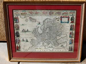
1664 – W. J. BLAEU – EUROPA RECENS DESCRIPTATitle: “Europa recens descripta a Guilielmo richly embellished map of Europe, which is an excellent representation of the decorative carte-a-figures style. Framed on both sides by five costumed figures, left border: Angli, Galli, Belgi, Castiliani, Venetiani and right border: Germani, Hungari, Bohemi, Poloni, Graeci. Along the upper edge runs a decorative border with nine European towns in oval frames: Amsterdam, Praga, Constantinopolis Venetia, Roma, Paris, London, Toledo and Lisboa. For European mapmakers their own continent contained few mysteries or secrets by the seventeenth century. However, the mythical island of Frisland still appears between Iceland and Greenland. The map is embellished with sailing ships, sea monsters, bears in northern Russia, and lions in North Africa and Neptune riding a dolphin and holding his trident.The map comes from rare Dutch edition atlas “Atlas Maior”, published by Joan Blaeu in 1664. Cartographer publisher: Willem Janszoon Blaeu (1571 – 1638)Sheet size: 44,8 x 58,3 cmPlace / Date:? 1664Technique: copper condition! Contemporary hand coloring. .Viewed through glass some brown spots from age, crease or fold line up the center, some frame nicks, as found, AS IS - NOT VIEWED OUT OF FRAME!
Note: This item has been sold and is no longer available. This page serves as a historical price reference for Map collectors and appraisers.
Original Listing Description
1664 – W. J. BLAEU – EUROPA RECENS DESCRIPTATitle: “Europa recens descripta a Guilielmo richly embellished map of Europe, which is an excellent representation of the decorative carte-a-figures style. Framed on both sides by five costumed figures, left border: Angli, Galli, Belgi, Castiliani, Venetiani and right border: Germani, Hungari, Bohemi, Poloni, Graeci. Along the upper edge runs a decorative border with nine European towns in oval frames: Amsterdam, Praga, Constantinopolis Venetia, Roma, Paris, London, Toledo and Lisboa. For European mapmakers their own continent contained few mysteries or secrets by the seventeenth century. However, the mythical island of Frisland still appears between Iceland and Greenland. The map is embellished with sailing ships, sea monsters, bears in northern Russia, and lions in North Africa and Neptune riding a dolphin and holding his trident.The map comes from rare Dutch edition atlas “Atlas Maior”, published by Joan Blaeu in 1664. Cartographer publisher: Willem Janszoon Blaeu (1571 – 1638)Sheet size: 44,8 x 58,3 cmPlace / Date:? 1664Technique: copper condition! Contemporary hand coloring. .Viewed through glass some brown spots from age, crease or fold line up the center, some frame nicks, as found, AS IS - NOT VIEWED OUT OF FRAME!
Note: This item has been sold and is no longer available. This page serves as a historical price reference for Map collectors and appraisers.