1874-77 5 Map Set Military Operations Atlanta Campaign Georgia Sherman Civil War
1874-77 5 Map Set Military Operations Atlanta Campaign Georgia Sherman Civil War
SOLD $695.00 Sold: Oct 28, 2023 on eBayOriginal Listing Description
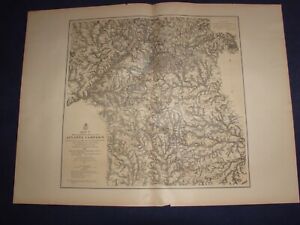
eBay Map[s] Illustrating the Military Operations of the Atlanta Campaign 1864 Compiled by the Authority of the Hon. the Secretary of War in the Office of the Chief of Engineers, U.S.A. [Set of 5 maps] [Georgia] by U.S. Army Corps of Engineers, Maj. Gen'l W. T. Sherman, Gen'l J. E. Johnston, and Gen'l J. B. Hood Complete set of 5 large sepia tinted lithographic maps, dated 1874-1877, with blue and red overprinting showing the lines of works of the United States and Confederate forces, and lines of march pursued by the separate armies, for illustrating the events of Sherman's Atlanta Campaign during the Spring and Summer of 1864; all with centerfold, as issued. Lithography by Julius Bien. An outstanding amount of detail and information is shown on these maps which were drawn from Union surveys and captured Confederate maps. Topography is rendered by finely drawn hachures which delineate the terrain in exquisite detail. Towns, roads and numerous individual homesites are shown, each identifying the landowner by name. Important battlefield sites of the campaign are shown, named and dated. The maps, with additional title information, include: Map I, This map embraces the region extending from the Tennessee River to the Oostanaula River and exhibits the works of the United States and Confederate forces...1875, 20 1/4 x 34 1/4 inches; Map II, This map includes the region from Resaca on the North to Ackworth on the south and exhibits the work of the United States and Confederate forces...1877, 25 x 27 1/2 inches; Map III,, This map includes the region extending from Rome, Kingston, Cassville on the north to include Dallas and Marietta on the south and the exhibits the works of the United States and Confederate forces...1876, 31 x 22 1/4 inches; Map IV, Embracing the region from Pine, Lost and Kennesaw Mountains south to include Atlanta and its environs, exhibiting the lines of operations at Pine, Lost and Kennesaw Mts., at Smyrna camp ground, along the Chattahoochie River, and in the investment of Atlanta...1874, 26 1/4 x 24 1/2 inches; and Map V, This map includes the region from the Chattahoochee River south to Jonesboro and Lovejoy's Station, and exhibits the works of the United States and Confederate forces, 26 x 25 inches. Condition: Light even age toning to paper. Paper is somewhat fragile with a short edge tear or two to each map limited to the blank margins, some closed with archival tissue tape on the back, and a few small edge chips. The original linen mounting strip, trimmed flush with paper surface, is still attached to the centerfold of all maps). All maps are clean and well preserved. A very good set.
Note: This item has been sold and is no longer available. This page serves as a historical price reference for Map collectors and appraisers.
Original Listing Description
eBay Map[s] Illustrating the Military Operations of the Atlanta Campaign 1864 Compiled by the Authority of the Hon. the Secretary of War in the Office of the Chief of Engineers, U.S.A. [Set of 5 maps] [Georgia] by U.S. Army Corps of Engineers, Maj. Gen'l W. T. Sherman, Gen'l J. E. Johnston, and Gen'l J. B. Hood Complete set of 5 large sepia tinted lithographic maps, dated 1874-1877, with blue and red overprinting showing the lines of works of the United States and Confederate forces, and lines of march pursued by the separate armies, for illustrating the events of Sherman's Atlanta Campaign during the Spring and Summer of 1864; all with centerfold, as issued. Lithography by Julius Bien. An outstanding amount of detail and information is shown on these maps which were drawn from Union surveys and captured Confederate maps. Topography is rendered by finely drawn hachures which delineate the terrain in exquisite detail. Towns, roads and numerous individual homesites are shown, each identifying the landowner by name. Important battlefield sites of the campaign are shown, named and dated. The maps, with additional title information, include: Map I, This map embraces the region extending from the Tennessee River to the Oostanaula River and exhibits the works of the United States and Confederate forces...1875, 20 1/4 x 34 1/4 inches; Map II, This map includes the region from Resaca on the North to Ackworth on the south and exhibits the work of the United States and Confederate forces...1877, 25 x 27 1/2 inches; Map III,, This map includes the region extending from Rome, Kingston, Cassville on the north to include Dallas and Marietta on the south and the exhibits the works of the United States and Confederate forces...1876, 31 x 22 1/4 inches; Map IV, Embracing the region from Pine, Lost and Kennesaw Mountains south to include Atlanta and its environs, exhibiting the lines of operations at Pine, Lost and Kennesaw Mts., at Smyrna camp ground, along the Chattahoochie River, and in the investment of Atlanta...1874, 26 1/4 x 24 1/2 inches; and Map V, This map includes the region from the Chattahoochee River south to Jonesboro and Lovejoy's Station, and exhibits the works of the United States and Confederate forces, 26 x 25 inches. Condition: Light even age toning to paper. Paper is somewhat fragile with a short edge tear or two to each map limited to the blank margins, some closed with archival tissue tape on the back, and a few small edge chips. The original linen mounting strip, trimmed flush with paper surface, is still attached to the centerfold of all maps). All maps are clean and well preserved. A very good set.
Note: This item has been sold and is no longer available. This page serves as a historical price reference for Map collectors and appraisers.