17h Century Antique Map of Africa by Blaeu, 1635
17h Century Antique Map of Africa by Blaeu, 1635
SOLD $3,000.00 Sold: Feb 2, 2024 on eBayOriginal Listing Description
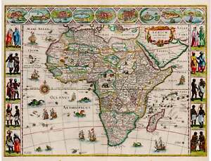
eBay Africae Nova DescriptioBy: Willem Janszoon BlaeuDate: 1635 (circa) 16 x 22 inches (40.5 x 56 cm)This is a superb example of the second state of Blaue’s important map of Africa, one of the iconic maps of the era by the leading map publisher of the Dutch Golden Age of cartography. By the time Blaeu made this map Europeans had navigated and subsequently charted Africa’s perimeter to the extent that in form it is close to a modern satellite image of it. The map was an immediate success, and several states of it were eventually published.The interior of the continent is divided into countries, kingdoms and colonies. The coasts are detailed with cities, ports and estuaries and the interior richly embellished with examples of African fauna. Myriad mountain ranges crisscross the continent, and large lakes and river systems are depicted.The top border features nine vignettes including cities such as Tangiers, Alexandria and Cairo to name a few, along with the island of Mozambique, the mine at St. George in Guinea, and the Canary Islands. The cities depict the wealth enjoyed by ports of the African continent in the 17th century. Each side border is formed by vignettes of indigenous peoples, men and women, in native costume. The decorative cartouche features a lion along with some luscious appearing fruit and other flora. Sea monsters frolic in the seas, which are dotted with seagoing vessels at full sail and even some flying fish.Condition: This map is in A condition with ample margins on all sides a lovely hand coloring. Inventory #120761932 S. Halsted St. #200 Chicago, IL 60608 | P: (312) 496 - 3622
Note: This item has been sold and is no longer available. This page serves as a historical price reference for Map collectors and appraisers.
Original Listing Description
eBay Africae Nova DescriptioBy: Willem Janszoon BlaeuDate: 1635 (circa) 16 x 22 inches (40.5 x 56 cm)This is a superb example of the second state of Blaue’s important map of Africa, one of the iconic maps of the era by the leading map publisher of the Dutch Golden Age of cartography. By the time Blaeu made this map Europeans had navigated and subsequently charted Africa’s perimeter to the extent that in form it is close to a modern satellite image of it. The map was an immediate success, and several states of it were eventually published.The interior of the continent is divided into countries, kingdoms and colonies. The coasts are detailed with cities, ports and estuaries and the interior richly embellished with examples of African fauna. Myriad mountain ranges crisscross the continent, and large lakes and river systems are depicted.The top border features nine vignettes including cities such as Tangiers, Alexandria and Cairo to name a few, along with the island of Mozambique, the mine at St. George in Guinea, and the Canary Islands. The cities depict the wealth enjoyed by ports of the African continent in the 17th century. Each side border is formed by vignettes of indigenous peoples, men and women, in native costume. The decorative cartouche features a lion along with some luscious appearing fruit and other flora. Sea monsters frolic in the seas, which are dotted with seagoing vessels at full sail and even some flying fish.Condition: This map is in A condition with ample margins on all sides a lovely hand coloring. Inventory #120761932 S. Halsted St. #200 Chicago, IL 60608 | P: (312) 496 - 3622
Note: This item has been sold and is no longer available. This page serves as a historical price reference for Map collectors and appraisers.