Rare Original 1910 Provincetown Bird's Eye View Map Pocket Massachusetts Mass MA
Rare Original 1910 Provincetown Bird's Eye View Map Pocket Massachusetts Mass MA
SOLD $349.00 Sold: Mar 6, 2024 on eBayOriginal Listing Description
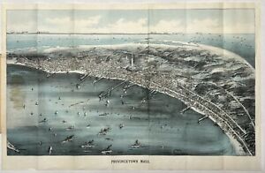
Selling a rare original 1910 Provincetown Bird’s Eye View pocket map.The map was published by Walker Lith. & Publishing Co., Boston Mass.Shows good detail of Provincetown street plan including: Provincetown Harbor, wharves, views of the monument, Clapps Pond, Race Point Light, Race Run and Race Point Life Saving Station. In the background it shows: Plymouth, Gurnet Light, Standish Monument, Duxbury Wireless Station, Blue Hills, Boston, Boston Light, Minot Light and the Boston Light Ship. Condition: - Very good overall condition with folds as issued. - Heavy cover with bank note paper map. - Glue appears on the left where it is attached to the cover. - see photos (may possibly be less evident when detached) - Cover can be detached or folded back for framing Measurements: (approx.) Map - Outside Paper 17.75” x 11.5” - Map Image 10.0” x 17.0” (unfolded) Cover 3.25” x 5.5” (folded)The map will be shipped flat and not folded.Please ask questions before purchasing ———————————— As noted on the Norman Leventhal Map and Education Center at the Boston Public in a northwesterly direction toward Cape Cod Bay and the distant Boston shoreline, this bird's eye view portrays Provincetown at a time when the town was transitioning from a community dependent on fishing to one whose economy and culture were increasingly tied to the annual influx of summer residents and a growing artists and writers community. The central focus of this view is most striking architectural feature, the Pilgrim Monument. This 252-foot tower was completed just as the view was published in 1910. Celebrating this locale's historic origins, the monument was built to commemorate the Mayflowers five-week stay at the tip of Cape Cod before the Pilgrims decided to shift their base to Plymouth Bay. The view also provides evidence of the community’s changing economy. Numerous wharves, a mixture of steam and sailing ships in the harbor, and three cold storage plants for processing fish; Consolidated Weir, Provincetown Cold Storage, and Fisherman's Cold Storage reflect the town’s reliance on maritime industries during the 19th century. On the other hand, the identification in the legend of several hotels (Pilgrim, New Central, Atlantic, Gifford, and Mt. Pleasant Houses) and the Star Theater foreshadow the town's developing tourist industry during the 20th century.”
Note: This item has been sold and is no longer available. This page serves as a historical price reference for Map collectors and appraisers.
Original Listing Description
Selling a rare original 1910 Provincetown Bird’s Eye View pocket map.The map was published by Walker Lith. & Publishing Co., Boston Mass.Shows good detail of Provincetown street plan including: Provincetown Harbor, wharves, views of the monument, Clapps Pond, Race Point Light, Race Run and Race Point Life Saving Station. In the background it shows: Plymouth, Gurnet Light, Standish Monument, Duxbury Wireless Station, Blue Hills, Boston, Boston Light, Minot Light and the Boston Light Ship. Condition: - Very good overall condition with folds as issued. - Heavy cover with bank note paper map. - Glue appears on the left where it is attached to the cover. - see photos (may possibly be less evident when detached) - Cover can be detached or folded back for framing Measurements: (approx.) Map - Outside Paper 17.75” x 11.5” - Map Image 10.0” x 17.0” (unfolded) Cover 3.25” x 5.5” (folded)The map will be shipped flat and not folded.Please ask questions before purchasing ———————————— As noted on the Norman Leventhal Map and Education Center at the Boston Public in a northwesterly direction toward Cape Cod Bay and the distant Boston shoreline, this bird's eye view portrays Provincetown at a time when the town was transitioning from a community dependent on fishing to one whose economy and culture were increasingly tied to the annual influx of summer residents and a growing artists and writers community. The central focus of this view is most striking architectural feature, the Pilgrim Monument. This 252-foot tower was completed just as the view was published in 1910. Celebrating this locale's historic origins, the monument was built to commemorate the Mayflowers five-week stay at the tip of Cape Cod before the Pilgrims decided to shift their base to Plymouth Bay. The view also provides evidence of the community’s changing economy. Numerous wharves, a mixture of steam and sailing ships in the harbor, and three cold storage plants for processing fish; Consolidated Weir, Provincetown Cold Storage, and Fisherman's Cold Storage reflect the town’s reliance on maritime industries during the 19th century. On the other hand, the identification in the legend of several hotels (Pilgrim, New Central, Atlantic, Gifford, and Mt. Pleasant Houses) and the Star Theater foreshadow the town's developing tourist industry during the 20th century.”
Note: This item has been sold and is no longer available. This page serves as a historical price reference for Map collectors and appraisers.