Antique 28 X 20" Broadside / Map Lincoln Park Yonkers New York 1893 , NY& N RR
Antique 28 X 20" Broadside / Map Lincoln Park Yonkers New York 1893 , NY& N RR
SOLD $300.00 Sold: Mar 23, 2024 on eBayOriginal Listing Description
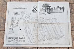
Celebrating more then 25 years as a leading seller of historical items on ebay .If you haven't saved me as a favorite seller yet please consider it ! As with ALL of our listings this is the vintage, real McCoy. This is NOT a copy, NOT a modern day replica. Guaranteed authentic Bought a Large Collection of Early maps , Documents and Broadsides all dealing with the Bronx NYC I will be listing lots over next two weeks !! This uncommon cadastral map offers an early overview of a portion of the Lincoln Park neighborhood in Yonkers, New York. The image, oriented with southwest at the top, numbers nearly 450 lots and their respective acreage between Sedgwick Ave., McLean Ave., Central Park Ave., and Van Cortlandt Park (in the NYC city limits).A profile of the namesake, Abraham Lincoln, can be seen in the upper center, adjacent to an illustrated view of an expansive corner lot. Also present is an inset map showing the location of the development in respect to the rest of New York City and an image of Lincoln Station on the N.Y. & Northern Railroad.The map was designed by Civil Engineer Josiah Ackerman Briggs and lithographed in New York by Robert A. WelckeShips folded on pre existing fold lines Stunning , Clean , Suitable for framing Please view all the photos to make an intelligent decision on condition.Over 25 Years on Ebay , 100% Feedback Thank you for visiting my store and viewing this item , stop by again I list fresh items 365 days a year !! , Mark me as a favorite PLEASE READ ALL THE BORING DETAILSCustomer Service Policy:Please note in bidding or buying this listing you are entering into a binding contract. In bidding or buying you are agreeing to all policies stated below . * Shipping is clearly stated / shown in the listing , by bidding or buying you are agreeing .* The auction or fixed price listing contains only what is described. Do not assume something comes with a used item if it is not stated in the auction / listing verbiage.* You can count on us to be factual as to the best of our knowledge and have clear accurate photographs. * Photographs often disclose condition far better than verbiage as many people have different ideas on what terms may mean.* If an identifying mark, inclusion or defect is visible in the images it is considered "disclosed" to the buyer.I strive to earn 5 Stars on all my transactions , If you feel I haven't please contact me before leaving feedback so that I can personally address your concerns and earn your 5 Star rating !Thank you very much for visiting my auctions I honestly appreciate it . Please add me as a Favorite seller , I list items 52 weeks a year . I list the Antique & Unique , Unusual things & items of distinction .
Note: This item has been sold and is no longer available. This page serves as a historical price reference for Map collectors and appraisers.
Original Listing Description
Celebrating more then 25 years as a leading seller of historical items on ebay .If you haven't saved me as a favorite seller yet please consider it ! As with ALL of our listings this is the vintage, real McCoy. This is NOT a copy, NOT a modern day replica. Guaranteed authentic Bought a Large Collection of Early maps , Documents and Broadsides all dealing with the Bronx NYC I will be listing lots over next two weeks !! This uncommon cadastral map offers an early overview of a portion of the Lincoln Park neighborhood in Yonkers, New York. The image, oriented with southwest at the top, numbers nearly 450 lots and their respective acreage between Sedgwick Ave., McLean Ave., Central Park Ave., and Van Cortlandt Park (in the NYC city limits).A profile of the namesake, Abraham Lincoln, can be seen in the upper center, adjacent to an illustrated view of an expansive corner lot. Also present is an inset map showing the location of the development in respect to the rest of New York City and an image of Lincoln Station on the N.Y. & Northern Railroad.The map was designed by Civil Engineer Josiah Ackerman Briggs and lithographed in New York by Robert A. WelckeShips folded on pre existing fold lines Stunning , Clean , Suitable for framing Please view all the photos to make an intelligent decision on condition.Over 25 Years on Ebay , 100% Feedback Thank you for visiting my store and viewing this item , stop by again I list fresh items 365 days a year !! , Mark me as a favorite PLEASE READ ALL THE BORING DETAILSCustomer Service Policy:Please note in bidding or buying this listing you are entering into a binding contract. In bidding or buying you are agreeing to all policies stated below . * Shipping is clearly stated / shown in the listing , by bidding or buying you are agreeing .* The auction or fixed price listing contains only what is described. Do not assume something comes with a used item if it is not stated in the auction / listing verbiage.* You can count on us to be factual as to the best of our knowledge and have clear accurate photographs. * Photographs often disclose condition far better than verbiage as many people have different ideas on what terms may mean.* If an identifying mark, inclusion or defect is visible in the images it is considered "disclosed" to the buyer.I strive to earn 5 Stars on all my transactions , If you feel I haven't please contact me before leaving feedback so that I can personally address your concerns and earn your 5 Star rating !Thank you very much for visiting my auctions I honestly appreciate it . Please add me as a Favorite seller , I list items 52 weeks a year . I list the Antique & Unique , Unusual things & items of distinction .
Note: This item has been sold and is no longer available. This page serves as a historical price reference for Map collectors and appraisers.