17th C. Map of VIRGINIA: Nova Virginia Tabula 2nd State 20”Height 24 2/8”Width
17th C. Map of VIRGINIA: Nova Virginia Tabula 2nd State 20”Height 24 2/8”Width
SOLD $950.00 Sold: Apr 9, 2024 on eBayOriginal Listing Description
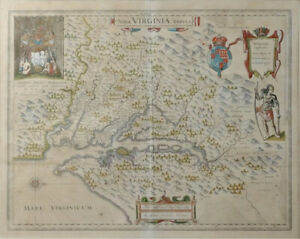
17th C. Map of Virginia: Nova Virginia Tabula 2nd State. Important Hand Colored early map, the second state of the first published map made after John Smith's map of the area around the Chesapeake Bay. Notable in part for its vignettes showing Native American Chief Powhatan, right side with bow and club, and upper left, presiding over a gathering in a dwelling where John Smith was held prisoner. The map shows Indian villages, identifies tribes, and, in a rare acknowledgement recognizes the places where Smith could go no further and relied on the information supplied by Native Americans, marking these areas with small Maltese crosses. Published by Willem Janszoon Blaeu (1571-1638) who purchased the copper plates of the first state from the widow of the publisher, Jodocus Hondius. On laid paper, with central crease, very minor foxing. Size: 20 inch Tall ……24 2/8 Inch Actual Currently Not Framed Please ask for additional Photos or other items needed.
Note: This item has been sold and is no longer available. This page serves as a historical price reference for Map collectors and appraisers.
Original Listing Description
17th C. Map of Virginia: Nova Virginia Tabula 2nd State. Important Hand Colored early map, the second state of the first published map made after John Smith's map of the area around the Chesapeake Bay. Notable in part for its vignettes showing Native American Chief Powhatan, right side with bow and club, and upper left, presiding over a gathering in a dwelling where John Smith was held prisoner. The map shows Indian villages, identifies tribes, and, in a rare acknowledgement recognizes the places where Smith could go no further and relied on the information supplied by Native Americans, marking these areas with small Maltese crosses. Published by Willem Janszoon Blaeu (1571-1638) who purchased the copper plates of the first state from the widow of the publisher, Jodocus Hondius. On laid paper, with central crease, very minor foxing. Size: 20 inch Tall ……24 2/8 Inch Actual Currently Not Framed Please ask for additional Photos or other items needed.
Note: This item has been sold and is no longer available. This page serves as a historical price reference for Map collectors and appraisers.