| Antique Map of North America ... | |
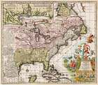
| Antique Map of North America showing 18th century colonial powers - Sold on eBay August 19th, 2024 for $2,200.00 | |
| Accurata delineatio celeberrimae Regionis Ludovicianae vel Gallice Louisiane ol. Canadae et Floridae Adpellatione in Septemtrionali America Descriptae quae Hodie Nomine Fluminis Mississippi vel St. Louis . . . By: Matthaus Seutter Date: 1720 (published) Augsburg Dimensions: 19.25 x 22.25 inches (49 x 56.5 cm) This remarkable map of North America spans from the French controlled northeast coast all the way to Spanish controlled New Mexico and New Spain. It depicts what was known of the territories shortly after the collapse of the speculative frenzy known as the Mississippi Bubble, and in fact ... | |
