|
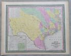
''MAP OF TEXAS FROM THE MOST RECENT AUTHORITIES… Philadelphia: Thomas, Cowperthwait & Co., 1850first issue. Fine engraved map with original hand coloringThis important historical map depicts Texas five years after statehood, and immediately after the 1850 Compromise that reduced the western boundary claim (along the Rio Grande northward to the Arkansas River). This is the first atlas map to show the reduced boundaries. Counties are named and in contrasting colors.The map accurately depicts the boundaries and river system, and locates major trails. Most cities, towns, military forts, the ''S... |

