1685 Frederick de Wit Map of Africa
1685 Frederick de Wit Map of Africa
SOLD $1,595.00 Sold: Sep 21, 2024 on eBayOriginal Listing Description
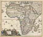
1685 Frederick de Wit Map of AfricaWE SELL ONLY ORIGINAL ANTIQUE MAPS - NOT Totius Africae Accuratissima Tabula Description: A beautiful example of Frederick De Wit's 1685 map of Africa. The map covers all of Africa as well as parts of Arabia, and the adjacent portions of the Atlantic, Indian, and Mediterranean. the map is a composite of earlier maps, including Jodocus Hondius's map of 1623, Willem Blaeu's map of 1617, and Visscher's map of 1658. The decorative cartouche, appearing in the lower left, features three Moors and a child on the left, and several African with two children on the right. This map follows the typical conventions of the period, but does exhibit several advances, mostly derived from judicious borrowing from other maps. The Nile follows the Ptolemaic model drawing its waters from to great lakes in the southern part of the continent, Zembre (Lake Zaire) andZaflan. On the west coast of the continent several Dutch trading stations, including Fort Nassau and Acara, are noted. It is curious that Dutch information from South Africa, nonetheless, are not present. In the Atlantic, here identified as the Oceanus Aethiopicus, the fictional island of Nuestra I. de Santa Helena, a common feature of contemporaneous French maps by Sanson and others, is identified.This map was published by De Wit in Amsterdam. The map was first issued in 1670 and there are at least six states of the map, the present example being state 4, identifiable by the inclusion of additional information in the interior €šÃ„ì such as the inclusion of Biafra, and the lack of a privilege, a kind of early copyright, which was added in the 5th edition.Size: Printed area measures 19.25 inches high by 23 inches wide.Condition: Very good. Verso repairs of centerfold separations. Closed tears professionally repaired on verso. Blank on verso.Shipping: Shipping rates are not negotiable. Items are shipped within three business days of receiving payment. We are happy to consolidate shipping where possible. The following shipping options are available: 1. FedEx Overnight (45 USD). USA Only. Signature Required. 2. FedEx Ground or Home Delivery (15 USD). USA Only. 1 - 10 days. If your address is a P.O. Box and cannot ship FedEx we will ship USPS Priority and, while we ship promptly, recent postal personnel cutbacks mean that delivery may take time. Signature Required. 3. FedEx International or DHL International EXPRESS (45 USD).4. We can use your FedEx Account Customs: International buyers are responsible for paying duty and taxes on delivery. DHL or FedEx will contact the buyer by telephone to arrange tax payment if it is levied. Duty varies by country and we cannot predict the amount you will be charged. Some countries are duty free, others are not. Typically, a customs duty and/or VAT tax will be assessed on all parcels to continental Europe. Sometimes duty or tax is due in China, but is seems very random. Hong Kong, Singapore, Korea, and Taiwan have never assessed duty on a map we shipped. Maps shipped to the UK should be duty free as educational materials, but from time to time duty of 5% is assessed incorrectly by the UK customs agents. Insurance: All shipments are insured privately against loss and damage. All of our shipments require a signature for insurance purposes. If you have any questions please feel free to email us through eBay.Other Framing: Geographicus recommends basic conservation framing services for any antique paper. We do not offer this service. Antique Map Restoration: Geographicus can repair and restore your antique map. Services include deacidification cleaning flattening and backing. BEWARE anyone attempting to contact you, from a different eBay account, claiming to represent Geographicus Antique Maps. My eBay handle is GeographicusMaps If you are contacted by email by someone offering you my items, please call me directly to be certain you are not dealing with a con artist. "
Note: This item has been sold and is no longer available. This page serves as a historical price reference for Map collectors and appraisers.
Original Listing Description
1685 Frederick de Wit Map of AfricaWE SELL ONLY ORIGINAL ANTIQUE MAPS - NOT Totius Africae Accuratissima Tabula Description: A beautiful example of Frederick De Wit's 1685 map of Africa. The map covers all of Africa as well as parts of Arabia, and the adjacent portions of the Atlantic, Indian, and Mediterranean. the map is a composite of earlier maps, including Jodocus Hondius's map of 1623, Willem Blaeu's map of 1617, and Visscher's map of 1658. The decorative cartouche, appearing in the lower left, features three Moors and a child on the left, and several African with two children on the right. This map follows the typical conventions of the period, but does exhibit several advances, mostly derived from judicious borrowing from other maps. The Nile follows the Ptolemaic model drawing its waters from to great lakes in the southern part of the continent, Zembre (Lake Zaire) andZaflan. On the west coast of the continent several Dutch trading stations, including Fort Nassau and Acara, are noted. It is curious that Dutch information from South Africa, nonetheless, are not present. In the Atlantic, here identified as the Oceanus Aethiopicus, the fictional island of Nuestra I. de Santa Helena, a common feature of contemporaneous French maps by Sanson and others, is identified.This map was published by De Wit in Amsterdam. The map was first issued in 1670 and there are at least six states of the map, the present example being state 4, identifiable by the inclusion of additional information in the interior €šÃ„ì such as the inclusion of Biafra, and the lack of a privilege, a kind of early copyright, which was added in the 5th edition.Size: Printed area measures 19.25 inches high by 23 inches wide.Condition: Very good. Verso repairs of centerfold separations. Closed tears professionally repaired on verso. Blank on verso.Shipping: Shipping rates are not negotiable. Items are shipped within three business days of receiving payment. We are happy to consolidate shipping where possible. The following shipping options are available: 1. FedEx Overnight (45 USD). USA Only. Signature Required. 2. FedEx Ground or Home Delivery (15 USD). USA Only. 1 - 10 days. If your address is a P.O. Box and cannot ship FedEx we will ship USPS Priority and, while we ship promptly, recent postal personnel cutbacks mean that delivery may take time. Signature Required. 3. FedEx International or DHL International EXPRESS (45 USD).4. We can use your FedEx Account Customs: International buyers are responsible for paying duty and taxes on delivery. DHL or FedEx will contact the buyer by telephone to arrange tax payment if it is levied. Duty varies by country and we cannot predict the amount you will be charged. Some countries are duty free, others are not. Typically, a customs duty and/or VAT tax will be assessed on all parcels to continental Europe. Sometimes duty or tax is due in China, but is seems very random. Hong Kong, Singapore, Korea, and Taiwan have never assessed duty on a map we shipped. Maps shipped to the UK should be duty free as educational materials, but from time to time duty of 5% is assessed incorrectly by the UK customs agents. Insurance: All shipments are insured privately against loss and damage. All of our shipments require a signature for insurance purposes. If you have any questions please feel free to email us through eBay.Other Framing: Geographicus recommends basic conservation framing services for any antique paper. We do not offer this service. Antique Map Restoration: Geographicus can repair and restore your antique map. Services include deacidification cleaning flattening and backing. BEWARE anyone attempting to contact you, from a different eBay account, claiming to represent Geographicus Antique Maps. My eBay handle is GeographicusMaps If you are contacted by email by someone offering you my items, please call me directly to be certain you are not dealing with a con artist. "
Note: This item has been sold and is no longer available. This page serves as a historical price reference for Map collectors and appraisers.