1868 Atlas of New York and Vicinity Map by Frederick Beers NYC Brooklyn Old Book
1868 Atlas of New York and Vicinity Map by Frederick Beers NYC Brooklyn Old Book
SOLD $299.99 Sold: Sep 22, 2024 on eBayOriginal Listing Description
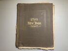
1868 Atlas of New York and Vicinity Map by Frederick Beers NYC Brooklyn Old Book Fresh from a Multi Generational wealthy estate dating back to the 1840’s. This is from the Varian Estate. Isaac L. Varian was the Mayor of New York City from 1839-41. You are buying a Great Piece of History! You will receive a 1868 Atlas of New York & Vicinity w/ Old Maps. Table of Contents: Plan of New York, Brooklyn Morrisania & West Farms Tremont & Surroundings Fordham, West Farms, Westchester, Villages of Wakefield, Olinville, Williams’ Bridge & Bronxdale, Unionport, Westchester, Schuylerville, Woodlawn Cemetery, Yonkers, Hastings, Dobb’s Ferry, Irvington, Tarrytown, Greenburg & Villages of Ashford & Hart’s Corners, East Chester, Lakeville Waverly Washingtonville Mount Vernon, Pelham and City Island, New Rochelle, Village of Pelhamville, White Plains & Scarsdale, Mamaroneck & Village Orienta, Mamaroneck & Rye Neck, Harrison & Rye and Villages of Rye & Milton, Village of Portchester, Mt. Pleasant and Villages of Pleasantville & Station, North Casetle, Kensico & Armonk, Ossining & Village of Sparta, Borough of Sing Sing, New Castle, Chappaqua, Mt. Kisco, Bedford, Beddford Station, Whitlockville & Katonah, Bedford, Poundridge, Lewisboro & Golden’s Bridge, South Salem, Cortlandt, Peekskill & Villages of Verplanck & Crugers, Yorktown & Shrub Oak & Jefferson Valley, Village of Somers, North Salem, Croton Falls, Purdy’s Station, Salem Centre, Phillipstown & Putnam Valley & Village of Carmel, Cold Spring, Nelsonville, South East Center, Milltown and Towner’s Station, Brester’s Station & Patterson, Kent… Etc. Please see the photos for the exact item you will receive. This Atlas Book is larger in size and has binding separation, some maps have rips and tears. Normal wear for ephemera/paper more than 157+ years old! Please ask any questions prior to bidding. You are buying the item as shown, as is, no returns. Great Historic piece! Please see the photos for the exact item you will receive. All items including Sports Cards, Vintage, Antiques & Collectibles are sold as shown with no returns. Please ask any questions prior to bidding. I will not accept any offer lower than the starting bid. Thank you for taking the time to look at my unique estate fresh treasures! Please check out my other items. Shipping in USA is $25 THANKS FOR LOOKING
Note: This item has been sold and is no longer available. This page serves as a historical price reference for Map collectors and appraisers.
Original Listing Description
1868 Atlas of New York and Vicinity Map by Frederick Beers NYC Brooklyn Old Book Fresh from a Multi Generational wealthy estate dating back to the 1840’s. This is from the Varian Estate. Isaac L. Varian was the Mayor of New York City from 1839-41. You are buying a Great Piece of History! You will receive a 1868 Atlas of New York & Vicinity w/ Old Maps. Table of Contents: Plan of New York, Brooklyn Morrisania & West Farms Tremont & Surroundings Fordham, West Farms, Westchester, Villages of Wakefield, Olinville, Williams’ Bridge & Bronxdale, Unionport, Westchester, Schuylerville, Woodlawn Cemetery, Yonkers, Hastings, Dobb’s Ferry, Irvington, Tarrytown, Greenburg & Villages of Ashford & Hart’s Corners, East Chester, Lakeville Waverly Washingtonville Mount Vernon, Pelham and City Island, New Rochelle, Village of Pelhamville, White Plains & Scarsdale, Mamaroneck & Village Orienta, Mamaroneck & Rye Neck, Harrison & Rye and Villages of Rye & Milton, Village of Portchester, Mt. Pleasant and Villages of Pleasantville & Station, North Casetle, Kensico & Armonk, Ossining & Village of Sparta, Borough of Sing Sing, New Castle, Chappaqua, Mt. Kisco, Bedford, Beddford Station, Whitlockville & Katonah, Bedford, Poundridge, Lewisboro & Golden’s Bridge, South Salem, Cortlandt, Peekskill & Villages of Verplanck & Crugers, Yorktown & Shrub Oak & Jefferson Valley, Village of Somers, North Salem, Croton Falls, Purdy’s Station, Salem Centre, Phillipstown & Putnam Valley & Village of Carmel, Cold Spring, Nelsonville, South East Center, Milltown and Towner’s Station, Brester’s Station & Patterson, Kent… Etc. Please see the photos for the exact item you will receive. This Atlas Book is larger in size and has binding separation, some maps have rips and tears. Normal wear for ephemera/paper more than 157+ years old! Please ask any questions prior to bidding. You are buying the item as shown, as is, no returns. Great Historic piece! Please see the photos for the exact item you will receive. All items including Sports Cards, Vintage, Antiques & Collectibles are sold as shown with no returns. Please ask any questions prior to bidding. I will not accept any offer lower than the starting bid. Thank you for taking the time to look at my unique estate fresh treasures! Please check out my other items. Shipping in USA is $25 THANKS FOR LOOKING
Note: This item has been sold and is no longer available. This page serves as a historical price reference for Map collectors and appraisers.