Antique 1855 Town Map Raynham MA Mass Massachusetts Henry Francis H F Walling
Antique 1855 Town Map Raynham MA Mass Massachusetts Henry Francis H F Walling
SOLD $435.00 Sold: Mar 25, 2025 on eBayOriginal Listing Description
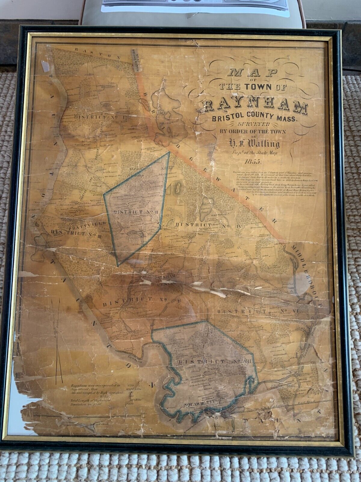
Antique 1855 (170 years old!!)Henry Francis WallingI love some of the script on this map: "The first forged in America was built here in 1652 by James and Henry Leonard and is now in constant operation.""On the north side of the fowling pond to King Phillips house. It was called Phillips hunting house because in the season most favorable for hunting he resided here but spent the winter chiefly at Mount Hope. He was finally shot by Alderman, an Indian, and his head was for some time kept in the cellar under the ancient Gothic house near the ironworks."1850 Population 1541This is currently framed in plexiglass. There are several cracks in the plexiglass.It's not properly mounted; there is about a half in of air gapping inside, which is allowing the map to gravity sink and bend/fold on itself. (aka it's not taped, pinned, etc.)Lower corner of the map missing. Several large cracks as evident in the pics.I am not a map guy, you should assume I know next to nothing about maps and ask any quantifying questions. Also - I am glad to ship as-in in this frame or rolled in a roll mailer. Please let me know your preference. If shipped as-in, I am worried that a few hard vertical bangs would put more gravity pressure on those floating map. That said - I will make sure to box as if this was as fragile as glass.Thanks :)Henry Francis WallingAdd Wikipedia, the free article includes a list of general references, but it lacks sufficient corresponding inline citations. Please help to improve this article by introducing more precise citations. (November 2021) (Learn how and when to remove this message)Henry Francis Walling (June 11, 1825 - April 8, 1889) was a notable American civil engineer and cartographer Walling was born in Burrillville, Rhode Island, where he was educated at public schools. After graduation he became an assistant librarian in the Providence Athenaeum, during which time he studied mathematics and surveying. He then entered the office of Samuel Barrett Cushing, a civil engineer in Providence, whose partner he became in 1846. He began topographic work in 1849, and prepared atlases containing full maps and scientific descriptions of most of the northern American states and the Dominion of Canada. After preparing at least 50 town maps in the Massachusetts vicinity, in 1855 he became the Commonwealth's Superintendent of the State Map. In 1856 he moved to New York City for its quality lithographers In 1867 Walling became chair of civil engineering in Lafayette, in which role he served for three years, but then resigned to accept an appointment as assistant in the Office of Coast Survey. He joined the newly-formed United States Geological Survey in 1883, and in 1884 was assigned to duty for the geodetic survey of Massachusetts in preparation of the state maps, on which work he was engaged at the time of his death.Walling was a Fellow of the American Association for the Advancement of Science and of the American Society of Civil Engineers Wallings died of a heart attack in Cambridge, needed] in 1889 [1]Raynham Massachusetts22 41°56?55?N Wikipedia, the free encyclopediaRaynham Town in Bristol County in 41°56?55?N • TypeOpen town meetingArea • Total20.9 sq mi (54.0 km2) • Land20.5 sq mi (53.1 km2) • Water0.4 sq mi (0.9 km2)Elevation81 ft (25 m)Population (2020) • Total15,142 • Density720/sq mi (280/km2)Time zoneUTC?5 (Eastern) • Summer (DST)UTC?4 (Eastern)ZIP Code02767Area code508/774FIPS code25 56060GNIS feature removed by eBay]Raynham (/?re?n?m/) is a town in Bristol County, Massachusetts, United States, located approximately 32 miles (51 km) south of Boston and 22 miles (35 km) northeast of Providence, Rhode Island. The population was 15,082 at the 2020 census.[1] It has one village, Raynham Center History[edit]The area that is now Raynham was settled in 1639 as a part of Taunton, and was founded by Elizabeth Pole, the first woman to found a town in America.It was to that area three years earlier that Roger Williams, proponent of separation of church and state, of paying Indians for land acquired and abolishing slavery, had escaped, traveling 55 miles during a January blizzard. He was fleeing a conviction for sedition and heresy of the General Court of Salem, and it was here that the local Wampanoags offered him shelter at their winter camp. Their Sachem Massasoit hosted Williams for the three months until spring.In 1652, bog iron was found along the Two Mile (Forge) River. Soon after, the Taunton Iron Works was established by residents James and Henry Leonard. It was the first successful iron works established in what was then Plymouth Colony, and operated from 1656 to 1876.[2] It was not the "First Iron Works in America", as proclaimed on the Town's official seal, having been predated by the Saugus and Braintree iron works. The success of the Taunton Iron Works, however, led to the establishment of other iron works throughout the colonies Raynham played a key part in King Philip's War. The Leonards had forged a friendship before the war began with King Philip, who lived in the area. It is said that Philip agreed to spare the town from the mass destruction if the Leonards repaired his troops' weapons in their iron forge.The eastern end of Taunton was separated from that town and incorporated as Raynham on April 2, 1731, named after the English village of Raynham in the county of Norfolk, England. Many ships' hulls were built along the Taunton River in Raynham, which were sailed down the river towards Fall River and Narragansett Bay for final fittings. The town also had other small manufacturing industries, but for the most part it was known for its rural and agrarian base [3]Transportation[edit]The intersection of Interstate 495 and Massachusetts Route 24, a four-lane divided highway, is located at the town's border with Bridgewater. Additionally, U.S. Route 44, Massachusetts Route 104 and Route 138 pass through the town. Route 24 has one exit which gives access to the town, Exit 20 (Route 44), and there is also a Raynham exit on Interstate 495: Exit 22 (Route 138).Raynham is one of the towns covered by the Greater Attleboro Taunton Regional Transit Authority (GATRA) bus service. The MBTA Commuter Rail's nearest stop is in neighboring Bridgewater, on the Middleborough Lakeville Line. The second phase of the MBTA's South Coast Rail project is proposed to extend the existing Stoughton Line south through Easton and Raynham to Fall River and New Bedford. The line would make a station stop at the proposed Raynham Place Station, which would be located next to Raynham Park.The nearest local airport is in Taunton; commercial air service exists at Logan International Airport in Boston and at T. F. Green Airport in Providence, Rhode Island Demographics[edit]Historical populationYearPop ± 18501 541— 18601 746 13 3 18701 713?1 9 18801 681?1 9 18901 340?20 3 19001 540 14 9 19101 725 12 0 19201 695?1 7 19302 136 26 0 19402 141 0 2 19502 426 13 3 19604 150 71 1 19706 705 61 6 19809 085 35 5 19909 867 8 6 200011 739 19 0 201013 383 14 0 202015 142 13 1 202315 649 3 3 Source: United States census records and Population Estimates Program data [4][5][6][7][8][9][10][11][12][13][14]As of the census[15] of 2000, there were 11,739 people, 4,143 households, and 3,231 families residing in the town. The population density was 572.7 inhabitants per square mile (221.1/km2). There were 4,209 housing units at an average density of 205.3 per square mile (79.3/km2). The racial makeup of the town was 96.54% White, 1.04% African American, 0.06% Native American, 0.69% Asian, 0.03% Pacific Islander, 0.71% from other races, and 0.94% from two or more races. Hispanic or Latino of any race were 0.83% of the population There were 4,143 households, out of which 36.7% had children under the age of 18 living with them, 63.8% were married couples living together, 10.6% had a female householder with no husband present, and 22.0% were non-families. Of all households 17.9% were made up of individuals, and 8.5% had someone living alone who was 65 years of age or older. The average household size was 2.80 and the average family size was 3.18.In the town, the population was spread out, with 25.7% under the age of 18, 6.8% from 18 to 24, 29.9% from 25 to 44, 24.7% from 45 to 64, and 13.0% who were 65 years of age or older. The median age was 38 years. For every 100 females, there were 91.8 males. For every 100 females age 18 and over, there were 88.5 males.The median income for a household in the town was $60,449, and the median income for a family was $68,354. Males had a median income of $46,954 versus $31,760 for females. The per capita income for the town was $24,476. About 3.2% of families and 4.1% of the population were below the poverty line, including 3.7% of those under age 18 and 9.0% of those age 65 or over Government[edit]The town is part of the Massachusetts House of Representatives 8th Plymouth district, which includes Bridgewater and part of Easton. It is also part of the Massachusetts Senate's 1st Plymouth and Bristol district, which includes Berkley, Bridgewater, Carver, Dighton, Marion, Middleborough, Taunton and Wareham. Raynham is patrolled by Massachusetts State Police#Troop D (Southeast District), 4th Barracks (located in Middleborough). On the national level, the town is part of Massachusetts's 4th congressional district, which is represented by Jake Auchincloss. The state's senior (Class I) Senator is Elizabeth Warren, and the state's junior (Class II) Senator is Ed Markey.Raynham is governed by an open town meeting and elects a board of selectmen, which directs a full-time town administrator. Patricia Riley, Joseph Pacheco and Kenneth Collins are the town elected selectmen. The Town Administrator is Gregory Barnes. The three members of the board of selectmen are elected at large on a staggered schedule. Basic services are centered around the town hall located at Raynham Center, including the police station and fire department. There are two post offices, located near Raynham Center and along Route 138 near North Raynham. The town also operates the Borden Colony Recreation Area, and there is a small State Forest in the town. The presidential results were mostly democratic until 2008, when the town narrowly voted for republican John McCain over democrat Barack Obama. It was also republican in 2012 and 2016 and it was democratic in 2020. In the 2024 United States presidential election, Republican Donald Trump received 4,694 votes, while Democrats Kamala Harris received 4,059 votes.Raynham presidential election results[16] partiesTotal VotesMargin202049 62 4,37248.16% 4,2432.22% 1968 8111 46 201643 93 3,32750.25% 3,8065.82% 4417 5746 32 201246 21 3,22252.46% 3,6581.33% 936 9736 25 200847 49 3,33650.17% 3,5242.33% 1647 0242 68 200450 75 3,22348.59% 3,0860.66% 426 3512 16 200054 53 3,12840.17% 2,3045.30% 3045 73614 37 199654 91 2,75132.40% 1,62312.69% 6365 01022 51 199235 56 1,83934.25% 1,77130.19% 1 5615 1711 32 198839 67 1,82059.00% 2,7071.33% 614 58819 33 198433 61 1,41865.99% 2,7840.40% 174 21932 38 198031 59 1,31952.49% 2,19215.92% 6654 17620 91 197648 00 1,77848.95% 1,8133.05% 1133 7040 94 197243 02 1,24256.46% 1,6300.52% 152 88713 44 196847 68 1,31546.59% 1,2855.73% 1582 7581 09 196465 63 1,57534.08% 8180.29% 72 40031 54 196043 75 90056.15% 1,1550.10% 22 05712 40 195624 61 40573.39% 1,2082.00% 331 64648 78 195230 67 42369.18% 9540.15% 21 37938 51 194839 64 44459.02% 6611.34% 151 12019 38 194434 45 31865.01% 6000.54% 592330 55 194033 50 33866.40% 6700.10% 11 00932 90 Education[edit]Raynham Public Library, with World War II, Civil War and World War I memorials on lawnRaynham belongs to the Bridgewater Raynham Regional School District. There are three schools in Raynham: L.B. Merrill Elementary School, housing Pre Kindergarten through first grade, LaLiberte Elementary School, housing second through fourth grades, and Raynham Middle School, housing fifth through eighth grades. Bridgewater Raynham Regional High School, located in Bridgewater, houses ninth through twelfth grades. The high school athletics teams are nicknamed the Trojans, and the primary colors are red and white, with blue trim. The BR School Committee consists of eight members. High school students may also attend Bristol Plymouth Regional Technical School, located in Taunton, or Bristol County Agricultural High School in Dighton. Students may also select to attend private and parochial schools in the neighboring towns.In recent years, discussions have taken place regarding the possibility of the withdrawal of Raynham's three pre kindergarten eighth grade schools from the Bridgewater Raynham Regional School District. The town cites an unfair funding formula, as well as Bridgewater's inability to fully fund the district, as its reasons for the proposal. However, on November 17, 2010, the proposal was unanimously defeated by voters at a special town meeting, thereby maintaining the current regional system Recreation[edit]Johnston Memorial ParkRaynham Park is located in Raynham and holds the world record for largest annual handle.[17] All racing at the park was formally ended on January 1, 2010, after the state election banned all greyhound racing. The building remains to host simulcast racing. In 2011, the Wampanoag Indian tribe indicated an interest in establishing a "Racino"-style gaming casino at the Raynham dog track,[18] but in August 2011 talks broke down [19]Religion[edit]Wat is host to several religious organizations of various religious denominations. Among the largest is St. Ann's Roman Catholic Church, Steeple Point Church (Home to the Raynham Food Basket), Calvary Chapel contemporary evangelical church, Lutheran Church of the Way, First Congregational Stone Church, and Father's House Family Protestant Church. Raynham is also home to Wat Nawamintararachutis opened in 2014 as the largest Thai Buddhist temple outside of Thailand. [20]Notable C. Anderson, received the United States military's highest decoration for valor, the Medal of Honor, for his action of capturing the battle flag of the 27th South Carolina regiment at the battle of Wheldon Railroad (also known as the Battle of Globe Tavern) near Petersburg, Virginia on September 6, 1864. Anderson was a member of the 18th Massachusetts Volunteer Regiment which was eventually transferred into the 32nd Regiment Massachusetts Volunteer Infantry which saw action in many of the major battles of the eastern campaign of the Civil War.Toby Gilmore, a former slave, volunteered in 1776 to serve in the Continental Army in place of his master who had been drafted. He served under General George Washington as tent master and is believed to have crossed the Delaware with him and spent the winter at Valley ForgeJared C. Monti, received the United States military's highest decoration for valor, the Medal of Honor, for his actions in Afghanistan attempting to rescue a wounded American soldier while under fire from enemy insurgents. Monti was killed in action in 2006 during this third attempt to rescue SPC Brian J. Bradbury. His actions are memorialized in the book "See You on the High Ground" written by Len Sandler, childhood friend of Monti's father.[21] Also, the story of his father Paul C. Monti driving in Jared's truck after his death has been memorialized in the 2012 Country Western song "I Drive Your Truck" by Lee Brice. The song won The Academy of Country Music and The Country Music Association awards for Song of the Year.[22]Gil Santos, the longtime radio play-by-play announcer for the New England Patriots of the National Football League
Note: This item has been sold and is no longer available. This page serves as a historical price reference for Map collectors and appraisers.
Original Listing Description
Antique 1855 (170 years old!!)Henry Francis WallingI love some of the script on this map: "The first forged in America was built here in 1652 by James and Henry Leonard and is now in constant operation.""On the north side of the fowling pond to King Phillips house. It was called Phillips hunting house because in the season most favorable for hunting he resided here but spent the winter chiefly at Mount Hope. He was finally shot by Alderman, an Indian, and his head was for some time kept in the cellar under the ancient Gothic house near the ironworks."1850 Population 1541This is currently framed in plexiglass. There are several cracks in the plexiglass.It's not properly mounted; there is about a half in of air gapping inside, which is allowing the map to gravity sink and bend/fold on itself. (aka it's not taped, pinned, etc.)Lower corner of the map missing. Several large cracks as evident in the pics.I am not a map guy, you should assume I know next to nothing about maps and ask any quantifying questions. Also - I am glad to ship as-in in this frame or rolled in a roll mailer. Please let me know your preference. If shipped as-in, I am worried that a few hard vertical bangs would put more gravity pressure on those floating map. That said - I will make sure to box as if this was as fragile as glass.Thanks :)Henry Francis WallingAdd Wikipedia, the free article includes a list of general references, but it lacks sufficient corresponding inline citations. Please help to improve this article by introducing more precise citations. (November 2021) (Learn how and when to remove this message)Henry Francis Walling (June 11, 1825 - April 8, 1889) was a notable American civil engineer and cartographer Walling was born in Burrillville, Rhode Island, where he was educated at public schools. After graduation he became an assistant librarian in the Providence Athenaeum, during which time he studied mathematics and surveying. He then entered the office of Samuel Barrett Cushing, a civil engineer in Providence, whose partner he became in 1846. He began topographic work in 1849, and prepared atlases containing full maps and scientific descriptions of most of the northern American states and the Dominion of Canada. After preparing at least 50 town maps in the Massachusetts vicinity, in 1855 he became the Commonwealth's Superintendent of the State Map. In 1856 he moved to New York City for its quality lithographers In 1867 Walling became chair of civil engineering in Lafayette, in which role he served for three years, but then resigned to accept an appointment as assistant in the Office of Coast Survey. He joined the newly-formed United States Geological Survey in 1883, and in 1884 was assigned to duty for the geodetic survey of Massachusetts in preparation of the state maps, on which work he was engaged at the time of his death.Walling was a Fellow of the American Association for the Advancement of Science and of the American Society of Civil Engineers Wallings died of a heart attack in Cambridge, needed] in 1889 [1]Raynham Massachusetts22 41°56?55?N Wikipedia, the free encyclopediaRaynham Town in Bristol County in 41°56?55?N • TypeOpen town meetingArea • Total20.9 sq mi (54.0 km2) • Land20.5 sq mi (53.1 km2) • Water0.4 sq mi (0.9 km2)Elevation81 ft (25 m)Population (2020) • Total15,142 • Density720/sq mi (280/km2)Time zoneUTC?5 (Eastern) • Summer (DST)UTC?4 (Eastern)ZIP Code02767Area code508/774FIPS code25 56060GNIS feature removed by eBay]Raynham (/?re?n?m/) is a town in Bristol County, Massachusetts, United States, located approximately 32 miles (51 km) south of Boston and 22 miles (35 km) northeast of Providence, Rhode Island. The population was 15,082 at the 2020 census.[1] It has one village, Raynham Center History[edit]The area that is now Raynham was settled in 1639 as a part of Taunton, and was founded by Elizabeth Pole, the first woman to found a town in America.It was to that area three years earlier that Roger Williams, proponent of separation of church and state, of paying Indians for land acquired and abolishing slavery, had escaped, traveling 55 miles during a January blizzard. He was fleeing a conviction for sedition and heresy of the General Court of Salem, and it was here that the local Wampanoags offered him shelter at their winter camp. Their Sachem Massasoit hosted Williams for the three months until spring.In 1652, bog iron was found along the Two Mile (Forge) River. Soon after, the Taunton Iron Works was established by residents James and Henry Leonard. It was the first successful iron works established in what was then Plymouth Colony, and operated from 1656 to 1876.[2] It was not the "First Iron Works in America", as proclaimed on the Town's official seal, having been predated by the Saugus and Braintree iron works. The success of the Taunton Iron Works, however, led to the establishment of other iron works throughout the colonies Raynham played a key part in King Philip's War. The Leonards had forged a friendship before the war began with King Philip, who lived in the area. It is said that Philip agreed to spare the town from the mass destruction if the Leonards repaired his troops' weapons in their iron forge.The eastern end of Taunton was separated from that town and incorporated as Raynham on April 2, 1731, named after the English village of Raynham in the county of Norfolk, England. Many ships' hulls were built along the Taunton River in Raynham, which were sailed down the river towards Fall River and Narragansett Bay for final fittings. The town also had other small manufacturing industries, but for the most part it was known for its rural and agrarian base [3]Transportation[edit]The intersection of Interstate 495 and Massachusetts Route 24, a four-lane divided highway, is located at the town's border with Bridgewater. Additionally, U.S. Route 44, Massachusetts Route 104 and Route 138 pass through the town. Route 24 has one exit which gives access to the town, Exit 20 (Route 44), and there is also a Raynham exit on Interstate 495: Exit 22 (Route 138).Raynham is one of the towns covered by the Greater Attleboro Taunton Regional Transit Authority (GATRA) bus service. The MBTA Commuter Rail's nearest stop is in neighboring Bridgewater, on the Middleborough Lakeville Line. The second phase of the MBTA's South Coast Rail project is proposed to extend the existing Stoughton Line south through Easton and Raynham to Fall River and New Bedford. The line would make a station stop at the proposed Raynham Place Station, which would be located next to Raynham Park.The nearest local airport is in Taunton; commercial air service exists at Logan International Airport in Boston and at T. F. Green Airport in Providence, Rhode Island Demographics[edit]Historical populationYearPop ± 18501 541— 18601 746 13 3 18701 713?1 9 18801 681?1 9 18901 340?20 3 19001 540 14 9 19101 725 12 0 19201 695?1 7 19302 136 26 0 19402 141 0 2 19502 426 13 3 19604 150 71 1 19706 705 61 6 19809 085 35 5 19909 867 8 6 200011 739 19 0 201013 383 14 0 202015 142 13 1 202315 649 3 3 Source: United States census records and Population Estimates Program data [4][5][6][7][8][9][10][11][12][13][14]As of the census[15] of 2000, there were 11,739 people, 4,143 households, and 3,231 families residing in the town. The population density was 572.7 inhabitants per square mile (221.1/km2). There were 4,209 housing units at an average density of 205.3 per square mile (79.3/km2). The racial makeup of the town was 96.54% White, 1.04% African American, 0.06% Native American, 0.69% Asian, 0.03% Pacific Islander, 0.71% from other races, and 0.94% from two or more races. Hispanic or Latino of any race were 0.83% of the population There were 4,143 households, out of which 36.7% had children under the age of 18 living with them, 63.8% were married couples living together, 10.6% had a female householder with no husband present, and 22.0% were non-families. Of all households 17.9% were made up of individuals, and 8.5% had someone living alone who was 65 years of age or older. The average household size was 2.80 and the average family size was 3.18.In the town, the population was spread out, with 25.7% under the age of 18, 6.8% from 18 to 24, 29.9% from 25 to 44, 24.7% from 45 to 64, and 13.0% who were 65 years of age or older. The median age was 38 years. For every 100 females, there were 91.8 males. For every 100 females age 18 and over, there were 88.5 males.The median income for a household in the town was $60,449, and the median income for a family was $68,354. Males had a median income of $46,954 versus $31,760 for females. The per capita income for the town was $24,476. About 3.2% of families and 4.1% of the population were below the poverty line, including 3.7% of those under age 18 and 9.0% of those age 65 or over Government[edit]The town is part of the Massachusetts House of Representatives 8th Plymouth district, which includes Bridgewater and part of Easton. It is also part of the Massachusetts Senate's 1st Plymouth and Bristol district, which includes Berkley, Bridgewater, Carver, Dighton, Marion, Middleborough, Taunton and Wareham. Raynham is patrolled by Massachusetts State Police#Troop D (Southeast District), 4th Barracks (located in Middleborough). On the national level, the town is part of Massachusetts's 4th congressional district, which is represented by Jake Auchincloss. The state's senior (Class I) Senator is Elizabeth Warren, and the state's junior (Class II) Senator is Ed Markey.Raynham is governed by an open town meeting and elects a board of selectmen, which directs a full-time town administrator. Patricia Riley, Joseph Pacheco and Kenneth Collins are the town elected selectmen. The Town Administrator is Gregory Barnes. The three members of the board of selectmen are elected at large on a staggered schedule. Basic services are centered around the town hall located at Raynham Center, including the police station and fire department. There are two post offices, located near Raynham Center and along Route 138 near North Raynham. The town also operates the Borden Colony Recreation Area, and there is a small State Forest in the town. The presidential results were mostly democratic until 2008, when the town narrowly voted for republican John McCain over democrat Barack Obama. It was also republican in 2012 and 2016 and it was democratic in 2020. In the 2024 United States presidential election, Republican Donald Trump received 4,694 votes, while Democrats Kamala Harris received 4,059 votes.Raynham presidential election results[16] partiesTotal VotesMargin202049 62 4,37248.16% 4,2432.22% 1968 8111 46 201643 93 3,32750.25% 3,8065.82% 4417 5746 32 201246 21 3,22252.46% 3,6581.33% 936 9736 25 200847 49 3,33650.17% 3,5242.33% 1647 0242 68 200450 75 3,22348.59% 3,0860.66% 426 3512 16 200054 53 3,12840.17% 2,3045.30% 3045 73614 37 199654 91 2,75132.40% 1,62312.69% 6365 01022 51 199235 56 1,83934.25% 1,77130.19% 1 5615 1711 32 198839 67 1,82059.00% 2,7071.33% 614 58819 33 198433 61 1,41865.99% 2,7840.40% 174 21932 38 198031 59 1,31952.49% 2,19215.92% 6654 17620 91 197648 00 1,77848.95% 1,8133.05% 1133 7040 94 197243 02 1,24256.46% 1,6300.52% 152 88713 44 196847 68 1,31546.59% 1,2855.73% 1582 7581 09 196465 63 1,57534.08% 8180.29% 72 40031 54 196043 75 90056.15% 1,1550.10% 22 05712 40 195624 61 40573.39% 1,2082.00% 331 64648 78 195230 67 42369.18% 9540.15% 21 37938 51 194839 64 44459.02% 6611.34% 151 12019 38 194434 45 31865.01% 6000.54% 592330 55 194033 50 33866.40% 6700.10% 11 00932 90 Education[edit]Raynham Public Library, with World War II, Civil War and World War I memorials on lawnRaynham belongs to the Bridgewater Raynham Regional School District. There are three schools in Raynham: L.B. Merrill Elementary School, housing Pre Kindergarten through first grade, LaLiberte Elementary School, housing second through fourth grades, and Raynham Middle School, housing fifth through eighth grades. Bridgewater Raynham Regional High School, located in Bridgewater, houses ninth through twelfth grades. The high school athletics teams are nicknamed the Trojans, and the primary colors are red and white, with blue trim. The BR School Committee consists of eight members. High school students may also attend Bristol Plymouth Regional Technical School, located in Taunton, or Bristol County Agricultural High School in Dighton. Students may also select to attend private and parochial schools in the neighboring towns.In recent years, discussions have taken place regarding the possibility of the withdrawal of Raynham's three pre kindergarten eighth grade schools from the Bridgewater Raynham Regional School District. The town cites an unfair funding formula, as well as Bridgewater's inability to fully fund the district, as its reasons for the proposal. However, on November 17, 2010, the proposal was unanimously defeated by voters at a special town meeting, thereby maintaining the current regional system Recreation[edit]Johnston Memorial ParkRaynham Park is located in Raynham and holds the world record for largest annual handle.[17] All racing at the park was formally ended on January 1, 2010, after the state election banned all greyhound racing. The building remains to host simulcast racing. In 2011, the Wampanoag Indian tribe indicated an interest in establishing a "Racino"-style gaming casino at the Raynham dog track,[18] but in August 2011 talks broke down [19]Religion[edit]Wat is host to several religious organizations of various religious denominations. Among the largest is St. Ann's Roman Catholic Church, Steeple Point Church (Home to the Raynham Food Basket), Calvary Chapel contemporary evangelical church, Lutheran Church of the Way, First Congregational Stone Church, and Father's House Family Protestant Church. Raynham is also home to Wat Nawamintararachutis opened in 2014 as the largest Thai Buddhist temple outside of Thailand. [20]Notable C. Anderson, received the United States military's highest decoration for valor, the Medal of Honor, for his action of capturing the battle flag of the 27th South Carolina regiment at the battle of Wheldon Railroad (also known as the Battle of Globe Tavern) near Petersburg, Virginia on September 6, 1864. Anderson was a member of the 18th Massachusetts Volunteer Regiment which was eventually transferred into the 32nd Regiment Massachusetts Volunteer Infantry which saw action in many of the major battles of the eastern campaign of the Civil War.Toby Gilmore, a former slave, volunteered in 1776 to serve in the Continental Army in place of his master who had been drafted. He served under General George Washington as tent master and is believed to have crossed the Delaware with him and spent the winter at Valley ForgeJared C. Monti, received the United States military's highest decoration for valor, the Medal of Honor, for his actions in Afghanistan attempting to rescue a wounded American soldier while under fire from enemy insurgents. Monti was killed in action in 2006 during this third attempt to rescue SPC Brian J. Bradbury. His actions are memorialized in the book "See You on the High Ground" written by Len Sandler, childhood friend of Monti's father.[21] Also, the story of his father Paul C. Monti driving in Jared's truck after his death has been memorialized in the 2012 Country Western song "I Drive Your Truck" by Lee Brice. The song won The Academy of Country Music and The Country Music Association awards for Song of the Year.[22]Gil Santos, the longtime radio play-by-play announcer for the New England Patriots of the National Football League
Note: This item has been sold and is no longer available. This page serves as a historical price reference for Map collectors and appraisers.