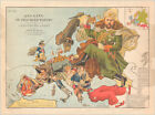
A never-folded example of Frederick W. Rose’s iconic 1899 caricature map of Europe on a collision course.A satirical rendition of Europe at the dawn of the 20th century, portraying the growing political tensions that lead up to World War I and the Russian Revolution.This delightful was drawn by Matt Hewerdine based on the designs of Frederick W. Rose, an English illustrator and satirist active in the second half of the 19th century. It is one in a series of highly decorative and satirical pictorial maps produced by Rose during the period of European industrialization While pictorial and satirical maps had been produced prior to Rose’s activities, most collectors agree that no one compiled this type of chart with the finesse and balance between ironic comedy and aesthetics that Rose achieved. Consequently, Angling in Troubled Waters is one of Rose’s most renowned maps and a milestone piece for any collection dealing with the period or genre.As indicated in the title, by the time this map was published Rose had already achieved some renown for his earlier work – in particular his famous Octopus Map of Europe (1877). Angling employs the same general structure as the Octopus map, forming the outline of Europe by drawing individual nations as satirical characters representing a particular set of values or specific references to political realities. At the same time – and this is part of what makes Rose’s work so remarkable – each nation’s characteristics can be linked to an overall theme, in this case the symbolic act of fishing (or angling).The map presupposes that the viewer has a basic understanding of the political divisions and overall situation in Europe at the time. Much of the unabashed symbolism in this chart is highly time-specific and would not necessarily make sense a decade or two later (or earlier for that matter). While the characters (nations) are part of a coherent whole both visually and geographically, each at the same time tells its own story, creating a tapestry of political interests and entanglements that together constitute a depiction of the state of affairs in Europe at the time. It is, in fact, quite genius. In many cases, the individual nations have been rendered in ways that pertain to very specific events from the late 1890s. In fact, as we shall see in the discussion of the individual characters below, a lot of this map’s symbolism draws on international events dating to 1898, only a year before the map’s initial publication Rose designed his maps to capture an idea or concern that he wished to highlight by tying them to a visual theme. In this case, the fishing metaphor is efficiently used to illustrate the external interests that most European nations entertained at the time. There are four nations physically engaged in actual fishing, all of which in this period still entertained imperial aspirations, but even for the nations not engaged in the act of fishing, the metaphor applies in the form of nets and landed catches. The four angling players are England, France, Tsarist Russia, and the Ottoman Empire. They have been poignantly represented on the map, with the national characters of each holding physical lines, representing the direction in which their interests as a nation lie. As such, it is both a commentary on the unsustainable and crumbling hegemonies of colonial empire, as well as an expression of deep concern regarding the growing internal tensions of Europe.Being a figurative and highly symbolic map, rich in detail, the publishers did not want the images to be misinterpreted or taken out of context. For this reason, two descriptive legends detailing the symbolic character of each nation is provided in the lower corners of the map. These, combined with our own study of the map, allow us to make a few comments regarding the manner in which each European nation has been depicted, as well as the motivation behind these symbolic depictions England is represented as John Bull – an imagined personification of the English, much like Uncle Sam is for Americans. Over his shoulder he already carries several nets (Ireland and Scotland), which contain a rich bounty of colonial possessions (including Burma). At his feet we find the key resources of ships, money, and men, and in his hands a fishing rod, at the end of which hangs a crocodile that represents Britain’s colonial aspirations in Egypt.France is represented as the internal struggle between civil and military power, aptly symbolized by the 1898 Dreyfus Affair. This scandal was an expression of the latent and insidious anti-Semitism inherent in European societies in the late 19th century, especially in times of economic hardship. The dishonorable and highly public dismissal of this loyal French officer, whose only crime was his Jewish background, resonated throughout the western world and set in motion a number of events still affecting the world today. In the crowd witnessing Dreyfus’ humiliation was a young Jewish journalist and intellectual from Vienna, who was so appalled by the scene that he became convinced that even the principles of modernity could not uproot the hatred of Jews in Europe. His name was Theodore Herzl, and in the years following the Dreyfus affair he would distill his thoughts into the principles of Zionism and write his famous manifesto, Der Judenstaat, which called for the creation of an actual Jewish State.In southern France, we see a reference to Panama, which symbolizes another major French scandal that took place a few years before the Dreyfus affair. A French company, in collaboration with two German-Jewish businessmen (Jacques Reinach & Cornelius Herz), lost circa half a billion Francs on the first and failed Panama Canal project. Hannah Arendt, a famous Jewish intellectual and historian, has argued that it was the involvement of German Jews in this scandal that helped re-ignite anti-Semitic sentiments in France and ultimately lead to the Dreyfus Affair.In general, France does not seem to enjoy much recognition on the map. In addition to bungling the Panama Canal, French colonial influence in Africa is waning as well, represented by a fish labeled ‘Fashoda.’ The fish has escaped the French line, a reference to a failed 1898 military campaign, in which the French army attempted to seize control of the White Nile in order to prevent British expansion into Mahdi Sudan.From Corsica, we see a diminutive version of the once great Napoleon, looking on as France throws away her global influence and presence. Despite the gloomy outlook, France has securely landed two good catches in the form of Tunis and Tonquin (referring to its North African and Vietnamese possessions) With Spain, we see the portrayal of a once great nation that has undergone the massive social and economic changes that seem to be the destiny of Europe’s other great colonial powers. Dressed as a matador, King Alfonso XIII looks with melancholy to the southwest, where three fish have been lost off lines extending west, out of the map. These represent Spain’s loss of Puerto Rico, Cuba, and the Philippines to the United States following the Treaty of Paris, which formally ended the Spanish American War (1898). Behind him, in a malevolent pose that seems to initiate an attack from behind, we see the looming figure of Infante or Don Carlos. As Duke of Madrid, Don Carlos was the senior living member of the House of Bourbon, and laid claim to the thrones of both Spain and France. Despite functioning as the de factoruler of Spain for four years following the Third Carlist War, he never actually achieved formal ascension to any European throne.In Portugal we see a well-dressed figure holding a large fish inscribed ‘Delagoa.’ The man represents the Portuguese state, and Delagoa is the region along the eastern coast of southern Africa. The image constitutes a symbolic reference to Portugal’s very lucrative sale of Mozambique to private corporations largely controlled by British financiers. With appropriate irony the caption reads: “Portugal seems likely to dispose of his catch to advantage; whereby his empty purse may assume rounder proportions ”And who other than the imposing figure of the Kaiser could represent the German Empire, whose many successes are acknowledged on the map, both in print and visually. An important detail, highly pertinent to the specific time in which this map was created, is a single fish stringed around the Kaiser’s waist. Labeled ‘Kiao Chau ’ it refers to a deal with Early Republican China in which Germany leased a large territory in Jiaozhou Bay on the Shangdong Peninsula. Germany’s presence in East Asia made a huge impact on its global standing as an industrial power and Jiaozhou soon became the East Asian headquarters for the German Imperial Navy. Yet despite his many recent successes, the Kaiser yearns for more and intensely surveys to the east for opportunity. Whether such opportunity could come in the form of trade, further industrialization or territorial expansion remains enigmatic, but his military attire and firm gaze seem suggestive of events to come.Smaller countries such as Holland, Belgium, and Denmark have been depicted as cute little realms, mostly interested in themselves. Holland is represented as her young and newly ascended Queen Wilhelmina, whereas Denmark, slightly more prominently, has been depicted as “the cradle of the royal races of Europe” (as stated in the legend). The aging Belgian King, Leopold II, looks content enough as he closely grasps his rich catch in Congo, but Rose’s strong sense of political and social irony is also present in the form of a large snake lying over the king’s shoulders labeled ‘Gambling Hells.’Other, smaller countries, or countries of insignificant political influence, have also been rendered somewhat mockingly. Serbia and Romania, for example, have been shown as children “almost too young to walk alone…”, whereas Norway and Sweden have been depicted as two dogs bound together by a leash but seemingly at odds with each other. The associated text notes that “…they may break the leash which binds them together and leave them prey to enterprising neighbours” — a reference to the increasingly strained Swedish Norwegian Union (1814-1905).To the south, Italy stands erect but perplexed and burdened by its massive public debts. Its people, represented on the map by Sardinia and Sicily, are downtrodden by heavy taxation as a consequence. Despite the dire economic situation at home, Italy nevertheless manages for now to hang on to its colonies in Eritrea and Somalia, denoted by three fish labeled Erythrea, Raheita, and Massowah (Massawa). Further east we find the first indications of an independent Greece, although he hardly cuts an impressive figure. A small figure, dwarfed by his large Turkish neighbor, we see how Greece has made an autonomous attempt to hook Crete – a great catch indeed – but seems to have pricked his finger in the process.Despite being much diminished from its former glory, one of the most prominent figures in the map is Ottoman Turkey. Like John Bull and the Spanish King, the Ottoman figure is attired in national garb, though somewhat more caricatured than his European counterparts. He has a massive nose and dons a traditional fez, red baggy pants, and Turkish slippers. Dominating much of the lower right of the image, Turkey looks curiously on Greece; cupping his ear to make sure he catches every detail of their rebellious activities, and perhaps of the general goings on in Europe. Despite the Greek attempt to catch it, Crete remains hooked on the Turkish line. One of the most notable features of the map is associated with the Ottomans, namely the skulls found on his elbow and knee. These represent the ethnic massacres conducted by the Ottoman military, the more famous of which of course is the Armenian genocide (here represented by the skull on the knee). The other represents similar massacres in Bulgaria Finally Russia is represented by the largest and most prominent figure on the map: Russian Tsar Nicholas II. Nicholas occupies a substantial portion of the composition and has an imposing and threatening air about him. He holds out an olive branch as a symbol of peace, but the branch stretches across Finland, where a large stockpile of Russian bombs, muskets, and cannonballs are obfuscated behind its leaves. The Tsar himself is also well armed, with both a sheathed saber and a pair of pistols in his belt. Over his shoulder hangs a large net in which a number of Central Asian fish have been securely caught. These include the ancient trade cities of Merv and Khiva.A third and fourth fish have been labeled ‘Ta Lien Wan’ and ‘Port Arthur’ respectively. These are references to the Russian influence exercised in northeastern China at the end of the 19th century. While Ta-Lien-Wan refers to the archipelago of Dalian Bay, Port Arthur refers to the naval base there, which was the British rendezvous point during the Second Opium War (1856-1860). The Tsar’s fishing line underlines Russian interests in China in that it extends to the eastern fringe of the image, where it seemingly has hooked an actual Chinese dragon.In the upper right corner we find a small colored inset map showing the real outlines of the European nations that have been represented pictorially in the larger map.In sum, we have a highly symbolic and complex depiction of Europe on the eve of the 20th century; a depiction, which both explicitly and implicitly refers to the current events of the day. With an express sense of the comical aspects in European politics, Rose has compiled a chart that almost predicts the immense devastation and social upheaval that the first decades of the 20th century would witness in Europe. Publication notesA final note should be made regarding the issue of this map. Like his Octopus Map (1877), Angling in Troubled Water was hugely popular and was printed in thousands of copies and in multiple editions. Despite its large circulation, however, the fragility of the paper on which it was printed has meant that most copies have perished over time. Consequently, it stands as a map of considerable rarity today. The exact chronology of issues remains unclear, but as international demand for the map rose, new states were issued with a subtitles in German, French, and Italian. Our copy is the original state published in London and issued without folds and with text written only in English.The map also carries two manuscript annotations in black ink that read ‘Mars 1899’. One is found in the upper right corner of the actual image, while the second is in the lower right corner, just outside the frame-line. We have not been able to identify the significance of this inscription, although it is likely to refer to a publishing or purchasing date (Mars = March in French), thus corroborating the early issue date Cartographer(s): Frederick William RoseFrederick William Rose (1849-1915) was a conservative British satirist and caricature artist active in the late 19th century. Despite the popularity of his posters and a considerable output, there has been some controversy regarding his exact identity, in part due to the commonplaceness of his name.More recent research (Barron 2008; 2016) has brought to light that Rose was of honorable Scottish descent and spent most of his professional life working as a civil-servant at Somerset House in London (Inland Revenue at the time). Having both married and divorced, Rose lost two sons in the early months of World War I and died shortly after, in 1915.During his lifetime, Rose travelled extensively throughout Europe and wrote numerous articles, reviews, and commentaries for the printed press. His first published book came in 1885 and was entitled Notes on a Tour in Spain. He later authored a number of other books. Today he is best known for his satirical output, in particular his caricature or ‘Serio Comic‘ maps, as he called them. His most famous map was the Octopus Map of Europe (1877), in which Russia is represented as an octopus grasping the rest of Europe. Even though this idea was copied from a Dutch caricaturist, J.J. van Brederode, it started a broader production of cartoon maps that served as ironic commentaries on current affairs across the continent George Washington BaconGeorge Washington Bacon (1830 – 1922) was an American mapmaker, publisher, and lithographer based in London. During the 1860s Bacon had opened a string of different business in London, but none of them had proven truly successful, and in 1867 he went personally bankrupt. It took him some years to bounce back, but in 1870 Bacon founded his publishing business: G.W. Bacon & Co. on the Strand. From here he set about issuing a range of popular maps, drawing largely on the compilations of Edward Well.By 1893, Bacon was able to acquire the mapmaking business of James Wyld, which cemented his firm’s standing. Not many years later, in 1900, Bacon’s firm was purchased by the Scottish publishing house W. & A.K. Johnston, but they continued to produce stand-alone maps under his iconic brand until 1956 ReferencesBarron Roderick2008 Bringing the Map to Life: European Satirical Maps 1845-1945. Belgeo (Belgian Journal of Geography) 3-4: 445-464 (https: doi org 10 4000 belgeo 11935)2016 Mistaken Attribution: Identifying the works of Fred W. Rose. Journal of the International Map Collectors’ Society 146: 15 28 Baynton Williams Ashley 2015 The Curious Map Book. University of Chicago Press, Chicago.
OCLC locates only one example of the 1873 edition of the map (Yale). Not in Rumsey (who notes editions of 1871 and 1874 and also identifies the Warren Heckrotte Copy of the 1873 edition). Also, an elaborate title and view of a steam engine and train station have replaced the more subdued 1864 title.
3D Raised Relief Topographic Map LOT of 18Beautiful vintage 3D maps featuring some of the Western US and surrounding areas. From the estate of a US Steel employee stationed in the Western US. Has been in storage for a couple of decades.These vintage maps precede the 'Hubbard' maps except for the Vernal map which has a Hubbard sticker attached Includes:Salem Canyon City,Klamath Falls Chico Susanville Redding San Jose,Walker Lake Fresno Death ValleyPLUSVictoria Cut Bank Gillette Santa Fe Flagstaff Mesa Holbrook TucsonThese measure roughly 30" x 21" (some are longer and some are shorter).**I do have dozens of these maps that I will be listing. Purchase up to 4 maps for a single shipping amount!!! Maps must be purchased at the same time, and the shipping discount will be in the form of a refund through eBay.****Fast and Secure Shipping Contact me with any questions, and good luck.
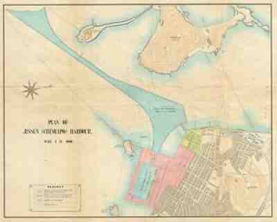
This is an important and rare map from that period. Title: Plan of Jinsen (Chemulpo) Harbour. The plan details the sections already constructed, in progress, dredged and proposed by color coding. It notes important landmarks including the Jinsen railway station, landing pier, custom house, etc. along with topography.
3D Raised Relief Topographic Map LOT of 16Beautiful vintage 3D maps featuring some of the Western US and surrounding areas. From the estate of a US Steel employee stationed in the Western US. Has been in storage for a couple of decades.These vintage maps precede the 'Hubbard' maps except for the Vernal map which has a Hubbard sticker attached Includes:Billings Butte Cedar City Challis Cody Cortez Elk City Greeley Hailey Hamilton Ogden Pocatello Price Thermopolis Vernal White Sulphur SpringsThese measure roughly 30" x 21" (some are longer and some are shorter).**I do have dozens of these maps that I will be listing. Purchase up to 4 maps for a single shipping amount!!! Maps must be purchased at the same time, and the shipping discount will be in the form of a refund through eBay.****Fast and Secure Shipping Contact me with any questions, and good luck.
It is printed on the bottom right "Ed. Oct. 15, 1863". The Second Battle Of Rappahannock Station began 3 weeks later on November 7, 1863. It is printed on paper with hand cut edges, slightly crooked.
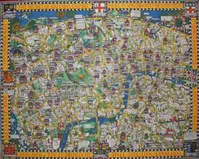
"Macdonald Gill's primary coloured Wonderground map was published early in 1914 and was hung at every station. 1914 London, with its population of seven million, was the capital of the largest empire the world had ever seen.
Pre-"Hubbard" 3D Raised Relief Topographic Map LOT of 10 - PRIVATE SALE vintage 3D maps featuring some of the Western US and surrounding areas. From the estate of a US Steel employee stationed in the Western US. Has been in storage for a couple of decades.These vintage maps precede the Hubbard branded maps Includes: Dillon Preston, Idaho Falls, Twin Falls, Dubois, Elko, Ely, Las Vegas, Copalis Beach, AshtonThese measure roughly 30" x 21" (some are longer and some are shorter).**I do have dozens of these maps that I will be listing. Purchase up to 4 maps for a single shipping amount!!! Maps must be purchased at the same time, and the shipping discount will be in the form of a refund through eBay.****Fast and Secure Shipping Contact me with any questions, and good luck.
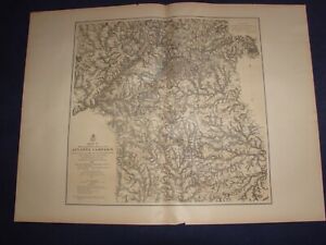
eBay Map[s] Illustrating the Military Operations of the Atlanta Campaign 1864 Compiled by the Authority of the Hon. the Secretary of War in the Office of the Chief of Engineers, U.S.A. [Set of 5 maps] [Georgia] by U.S. Army Corps of Engineers, Maj. Gen'l W. T. Sherman, Gen'l J. E. Johnston, and Gen'l J. B. Hood Complete set of 5 large sepia tinted lithographic maps, dated 1874-1877, with blue and red overprinting showing the lines of works of the United States and Confederate forces, and lines of march pursued by the separate armies, for illustrating the events of Sherman's Atlanta Campaign during the Spring and Summer of 1864; all with centerfold, as issued. Lithography by Julius Bien. An outstanding amount of detail and information is shown on these maps which were drawn from Union surveys and captured Confederate maps. Topography is rendered by finely drawn hachures which delineate the terrain in exquisite detail. Towns, roads and numerous individual homesites are shown, each identifying the landowner by name. Important battlefield sites of the campaign are shown, named and dated. The maps, with additional title information, include: Map I, This map embraces the region extending from the Tennessee River to the Oostanaula River and exhibits the works of the United States and Confederate forces...1875, 20 1/4 x 34 1/4 inches; Map II, This map includes the region from Resaca on the North to Ackworth on the south and exhibits the work of the United States and Confederate forces...1877, 25 x 27 1/2 inches; Map III,, This map includes the region extending from Rome, Kingston, Cassville on the north to include Dallas and Marietta on the south and the exhibits the works of the United States and Confederate forces...1876, 31 x 22 1/4 inches; Map IV, Embracing the region from Pine, Lost and Kennesaw Mountains south to include Atlanta and its environs, exhibiting the lines of operations at Pine, Lost and Kennesaw Mts., at Smyrna camp ground, along the Chattahoochie River, and in the investment of Atlanta...1874, 26 1/4 x 24 1/2 inches; and Map V, This map includes the region from the Chattahoochee River south to Jonesboro and Lovejoy's Station, and exhibits the works of the United States and Confederate forces, 26 x 25 inches. Condition: Light even age toning to paper. Paper is somewhat fragile with a short edge tear or two to each map limited to the blank margins, some closed with archival tissue tape on the back, and a few small edge chips. The original linen mounting strip, trimmed flush with paper surface, is still attached to the centerfold of all maps). All maps are clean and well preserved. A very good set.
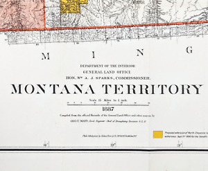
eBay EXTREMELY RARE ORIGINAL 1887 ANTIQUE LAND OFFICE MAP OF MONTANA TERRITORYDATED 1887 BELOW TITLEPUBLISHED BY-UNITED STATES GENERAL LAND OFFICE, WILLIAM SPARKSORIGINAL ANTIQUE 1887 MAP OF THE TERRITORY OF MONTANA. RARE AND VERY LARGE LAND OFFICE MAP OF MONTANA TERRITORY SHOWING TOWNSHIPS, COUNTY LINES, INDIAN RESERVATION, RAILWAYS, RAILWAY STATIONS, SURVEYED AND UNSURVEYED AREAS, UNEXPLORED REGIONS, MILITARY RESERVATIONS, RAILROAD LAND GRANT LIMITS AND PROPOSED RAILWAYS. ORANGE AREA REPRESENTS THE EXTENSIONS OF THE NORTHERN CHEYENNE RESERVATION LANDS. ALSO SHOWN IS YELLOWSTONE PARK, FORT CUSTER, LAND DISTRICT BOUNDARIES AND WATERWAYS. THIS MONTANA TERRITORY MAP WAS THE MOST ACCURATE AND CONTAINED THE MOST UP TO DATE INFORMATION AT THE TIME OF PUBLISHING. MAP IS EXTREMELY RARE AND THE ONLY ONE FOR SALE. LARGE FORMAT MAPS OF THE TERRITORY SELDOM COME UP FOR SALE.MEASURES 39 X 26 INCHESGOOD CONDITION, MAP HAS SEAM SPLITS ON CREASES AT SIDE EDGES AND AT MISSOULA COUNTYMAP WILL BE SHIPPED IN A TUBE
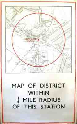
[SOUTHGATE STATION] - â??MAP OF DISTRICT WITHIN 1/4 MILE RADIUS OF THIS STATIONâ??. 97 x 59 cm (map: 56 x 52 cm). Laid on linen as issued. Original outline colour. Excellent condition. Southgate station opened on 13 March 1933 on the second phase of the northern extension of the Piccadilly line from Finsbury Park to Cockfosters.
1960 First Edition Folding Map of the "Greenwich Village Section of New York City" by Cartographer Lawrence FaheyPlease refer to pictures for condition. The map is kept and will arrive in folded state. I'm more than happy to try and answer questions but Maps are not my area of expertise. This map was found in an estate auction in 2021 that was included with a full lot of lithographs and woodcut prints. Map of the Greenwich Village Section of New York CityLawrence Fahey, New York: 1961, Second EditionColor process print18.75 x 24.5 inches, printed border21 x 33.5 inches, overallMore Info Found Online: Large and detailed map of Greenwich Village intended to be of practical use to visitors, at a time when “the Village” was the center of Bohemian culture and the New York avant garde arts scene. Greenwich Village is a lower Manhattan neighborhood in New York City. The degree of detail makes this a fascinating historical document of the neighborhood at that particular point in time. The map extends from 14th Street in the north to Prince Street in the south, and from 7th Avenue to the west to Broadway in the east. Printed in white, green and red, the major buildings are drawn in aerial perspective and trees are indicated by small green lollipop shapes. Public buildings are shown in white, all others in red. The featured buildings include churches, stores, galleries, theaters, New York University campus buildings, monuments, fire stations, hospitals, schools and restaurants. Directions of one- and two-way streets are indicated. There is a compass rose in the lower left corner and in the lower right corner, a cartouche with a border combining images of a European settler and a Native American standing on either side of New York City’s coat of arms, and baroque decoration twined with flowers. The cartouche was taken from the British Royal Army lieutenant Bernard Ratzer’s Plan of the City of New York in North America (1775). Text in the cartouche indicates the map originally sold for $3. On the far left side of the print next to the map is a separate key with text as well as an “Index” to featured places shown on the map organized by letters and numbers on the map grid. This example is the first edition of this map was published in 1960; the second edition was published in 1961.
The Alaska Line. When You Think Alaska-Think Alaska Steamship Co.Author: Alaska Steamship Co.Title: The Alaska Line. When You Think Alaska-Think Alaska Steamship Co.Description: Chicago: Alaska Steamship Company; Poole Bros., printers, 1917. Folding map, 53 x 77 cm, plus margins. CONDITION: One 8.5 cm tear at bottom-left corner, several small separations along old folds, but no losses to the map. A promotional map for a cruise from Seattle, Washington to Alaska, published roughly a decade after the height of the Klondike Gold Rush (1896-1899) and reflecting development in the state in the first two decades of the twentieth century.This map depicts Alaska, the Klondike District, and the westernmost portion of the Northwest Territory. Highlighted in red are over a dozen salient features in the Klondike and elsewhere: coal and gold fields, copper mines, salmon districts, oil fields, gold placers, a U.S. Seal Preserve, and so on. The inset map at the upper right entitled Map of the Copper River & Northwestern Railway and the Alaska Railroad depicts the Copper River Region (labeled the "Great Copper Belt"), and shows automobile highways, military telegraph lines, stage routes and rails, and "wireless stations."Red lines trace intersecting water and land routes to the Klondike and other locales; black lines indicate railroad lines, and steamship routes thread through islands and touch at various harbors. A scale of miles appears at the bottom-middle, and a table of distances records various distances from Seattle to thirteen Alaskan locales. Established in 1894 primarily for passenger service and fishing products, the Alaska Steamship Co. began to ship mining equipment, dog sleds, cattle, etc. to Alaska with the onset of the Klondike Gold Rush in 1897. In 1909, the company was purchased by the Alaska Syndicate and merged with the Northwestern Steamship Company but retained its name; at that time its fleet was expanded to eighteen ships. During the Second World War the U.S. government took control of the Steamship Co.'s ships. The Poole Brothers were leading printers and publishers of maps, guidebooks, brochures, and other promotional publications. Founded in 1870 by George Amos and William H. Poole, the firm operated until 1968. Servicing nearly every railroad in America, the Poole Bros. became the largest printing house in the country specializing in transportation and travel publications later expanding to periodicals, such as Advertising Age and the New England Journal of Medicine. Among the numerous titles to their credit are: Map of the Atchison, Topeka and Santa Fe R.R. Leased Lines and Connections (1884), Northern Pacific Railway and Connections (1887), Gold Fields of Alaska and How to Reach Them (1898) and Map of Burlington Route (1907). Item #5189Seller ID: 5189Subject: MapsTerms and Conditions All of the items we offer are guaranteed to be as described. We do not sell facsimiles or reproductions, and strive to be as accurate as possible in dating the items offered. Please see our other listings for a fine selection of books, prints, photographs, paper, and art! Our Policies Buyer is responsible for all shipping charges, including insurance, if desired. We ship through the United States Postal Service and UPS. While all items are professionally and securely packaged, we recommend insurance, as we cannot accept responsibility for lost or damaged items. Payment must be received within two weeks of commitment to purchase, or the item will be relisted. We prefer Paypal, but will consider other payment options. For International Buyers We adhere to all customs regulations and state the purchase price as the value for all items on customs forms, as required by law. All import duties, taxes, fees and charges are the responsibility of the buyer, and are not included in the purchase price.This listing was created by Bibliopolis.
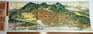
eBay RARE Original Map Bird's Eye View of Kyoto & Environs in Colorful Wrapsca 1947 For offer, an ORIGINAL map. Fresh from a local estate - never offered on the market until now. Vintage, Old, antique, Original - NOT a Reproduction - Guaranteed !! This interesting map came from the belongings of a WWII soldier who brought this back home after the war / occupation. Great detail! Bird's-eye view, pictorial map of Kyoto folded into heavy paper covers. Map showing buildings, trees, parks, landmarks, roads, railroads, rivers, etc. Title and text, tourist information in English and Japanese and place names in Japanese. Folding travel / tourist map. Measures 29 1/4 x 10 1/2 inches. In very condition. Map is excellent. Light foxing to cover wraps. Displays very nicely. Please see photos for details. If you collect Japanese history, 20h century geography, atlas, etc., this is one you will not see again. A nice piece for your paper / ephemera collection. Perhaps some genealogy research information as well. Combine shipping on multiple bid wins! 2603 Kyoto ( ?kjo?to? ;[3] Japanese: ??, Ky?to [k?o??to] (About this soundlisten)), officially Kyoto City (???, Ky?to-shi, (About this soundlisten)), is the capital city of Kyoto Prefecture in Japan. Located in the Kansai region on the island of Honshu, Kyoto forms a part of the Keihanshin metropolitan area along with Osaka and Kobe. As of 2021, the city has a population of 1.45 million, making up 57% of the prefecture's total population. The city is the cultural anchor of a substantially larger metropolitan area known as Greater Kyoto, a metropolitan statistical area (MSA) home to a census estimated 3.8 million people in 2020 and ranking as the second MSA in the Kansai region OverviewKyoto is one of the oldest municipalities in Japan, having been chosen in 794 as the new seat of Japan's imperial court by Emperor Kanmu. The original city, named Heian-ky?, was arranged in accordance with traditional Chinese feng shui following the model of the ancient Chinese capital of Chang an Luoyang The emperors of Japan ruled from Kyoto in the following eleven centuries until 1869. It was the scene of several key events of the Muromachi period, Sengoku period, and the Boshin War, such as the ?nin War, the Honn?-ji Incident, the Kinmon incident and the Battle of Toba–Fushimi. Upon the Imperial Court victory over the Tokugawa shogunate, the capital was relocated to Tokyo after the Meiji Restoration. The modern municipality of Kyoto was established in 1889. The city was spared from large-scale destruction during World War II and as a result, its prewar cultural heritage has mostly been preserved.Kyoto is considered the cultural capital of Japan and a major tourist destination. It is home to numerous Buddhist temples, Shinto shrines, palaces and gardens, some of which are listed collectively by UNESCO as a World Heritage Site. Prominent landmarks include the Kyoto Imperial Palace, Kiyomizu-dera, Kinkaku-ji, Ginkaku-ji and the Katsura Imperial Villa. Kyoto is also a center of higher learning, with Kyoto University being an institution of international renown NameEtymologyIn Japanese, Kyoto was previously called Ky? (?), Miyako (?), or Ky? no Miyako (???). In the 11th century, the city was renamed "Ky?to" (??, "capital city"), from the Middle Chinese kiang-tuo (cf. Mandarin j?ngd?).[4] After the city of Edo was renamed "T?ky?" (??, meaning "Eastern Capital") in 1868 and the seat of the emperor was moved there, Kyoto was for a short time known as "Saiky?" (??, meaning "Western Capital"). Kyoto is also sometimes called the thousand-year capital (????) The National Diet never officially passed any law designating a capital.[5] Foreign spellings for the city's name have included Kioto, Miaco and Meaco, utilized mainly by Dutch cartographers. Another term commonly used to refer to the city in the pre-modern period was Keishi (??), capital [6]GeographyKyoto seen from Mount Atago in the northwest corner of the is located in a valley, part of the Yamashiro (or Kyoto) Basin, in the eastern part of the mountainous region known as the Tamba highlands. The Yamashiro Basin is surrounded on three sides by mountains known as Higashiyama, Kitayama and Nishiyama, with a height just above 1,000 meters (3,281 ft) above sea level. This interior positioning results in hot summers and cold winters. There are three rivers in the basin, the Ujigawa to the south, the Katsuragawa to the west, and the Kamogawa to the east. Kyoto City takes up 17.9% of the land in the prefecture with an area of 827.9 square kilometers (319.7 sq mi).The original city was arranged in accordance with traditional Chinese feng shui following the model of the ancient Chinese capital of Chang an Luoyang The Imperial Palace faced south, resulting in Uky? (the right sector of the capital) being on the west while Saky? (the left sector) is on the east. The streets in the modern-day wards of Nakagy?, Shimogy?, and Kamigy?-ku still follow a grid pattern.Today, the main business district is located to the south of the old Imperial Palace, with the less-populated northern area retaining a far greener feel. Surrounding areas do not follow the same grid pattern as the center of the city, though streets throughout Kyoto share the distinction of having names.Kyoto sits atop a large natural water table that provides the city with ample freshwater wells. Due to large-scale urbanization, the amount of rain draining into the table is dwindling and wells across the area are drying at an increasing rate ClimateKyoto has a humid subtropical climate (Köppen Cfa), featuring a marked seasonal variation in temperature and precipitation. Summers are hot and humid, but winters are relatively cold with occasional snowfall. Kyoto's rain season begins around the middle of June and lasts until the end of July, yielding to a hot and sunny latter half of the summer. Kyoto, along with most of the Pacific coast and central areas of Japan is prone to typhoons during September and October Historically Kyoto was the largest city in Japan, later surpassed by Osaka and Edo (Tokyo) towards the end of the 16th century. In the pre-war years, Kyoto traded places with Kobe and Nagoya ranking as the 4th and 5th largest city. In 1947, it went back to being 3rd. By 1960 it had fallen to 5th again, and by 1990 it had fallen to 7th. As of 2015, it has been ranked the 9th largest city in Japan.Greater KyotoSee also: Greater KyotoThe concentration of population to the capital city area is 55%, which is highest among the prefectures. The economic difference between the coastal area and inland area including Kyoto basin is significant. Encompassing ¥10.12 trillion, Kyoto MEA has the fourth-largest economy in the country in 2010 [10]HistorySee also: Timeline of archeological evidence suggests human settlement in the area of Kyoto began as early as the Paleolithic period,[11] although not much published material is retained about human activity in the region before the 6th century, around which time the Shimogamo Shrine is believed to have been established GalleryShimogamo Shrine?Kamo Shrine? Kamigamo Shrine?Kamo Shrine?Heian ky?Main article: Heian ky?During the 8th century, when powerful Buddhist clergy became involved in the affairs of the imperial government, Emperor Kanmu chose to relocate the capital in order to distance it from the clerical establishment in Nara. His last choice for the site was the village of Uda, in the Kadono district of Yamashiro Province [12]The new city, Heian-ky? (???, "tranquility and peace capital"), a scaled replica of the then Chinese Tang dynasty capital Chang'an,[13] became the seat of Japan's imperial court in 794, beginning the Heian period of Japanese history. Although military rulers established their governments either in Kyoto (Muromachi shogunate) or in other cities such as Kamakura (Kamakura shogunate) and Edo (Tokugawa shogunate), Kyoto remained Japan's capital until the transfer of the imperial court to Tokyo in 1869 at the time of the Imperial Restoration GalleryEmperor Kanmu Daidairi (palace in the center) and the cityscape of Heian ky?Middle AgesSengoku periodThe city suffered extensive destruction in the ?nin War of 1467–1477, and did not really recover until the mid-16th century. During the ?nin War, the shugo collapsed, and power was divided among the military families.[14] Battles between samurai factions spilled into the streets, and came to involve the court nobility (kuge) and religious factions as well. Nobles' mansions were transformed into fortresses, deep trenches dug throughout the city for defense and as firebreaks, and numerous buildings burned. The city has not seen such widespread destruction since.In the late 16th century, Toyotomi Hideyoshi reconstructed the city by building new streets to double the number of north–south streets in central Kyoto, creating rectangle blocks superseding ancient square blocks. Hideyoshi also built earthwork walls called odoi (???) encircling the city. Teramachi Street in central Kyoto is a Buddhist temple quarter where Hideyoshi gathered temples in the city Gallery?nin War Nij? Castle Toyotomi Hideyoshi JurakudaiEarly modern periodEdo the Edo period, the economy of the city flourished as one of three major cities in Japan, the others being Osaka and Edo.GalleryMap of Heian-ky?, 1696 Sanj? ?hashi (The Fifty-three Stations of the T?kaid?) Perspective Pictures of Places in Japan: Sanj?sangen d? in KyotoToyoharu, c. 1772–1781 Fushimi CastleLate modern periodMeiji periodThe Hamaguri rebellion of 1864 burnt down 28,000 houses in the city which showed the rebels' dissatisfaction towards the Tokugawa Shogunate.[15] The subsequent move of the emperor to Tokyo in 1869 weakened the economy. The modern city of Kyoto was formed on April 1, 1889. The construction of Lake Biwa Canal in 1890 was one measure taken to revive the city. The population of the city exceeded one million in 1932 [8]GalleryKinmon incident Battle of Toba–Fushimi (Boshin War) View of Kyoto from beside the Hond? of Kiyomizudera. – 1879[16] Nanzenji historyModern KyotoKyoto International Conference CenterThere was some consideration by the United States of targeting Kyoto with an atomic bomb at the end of World War II because, as an intellectual center of Japan, it had a population large enough to possibly persuade the emperor to surrender.[17] In the end, at the insistence of Henry L. Stimson, Secretary of War in the Roosevelt and Truman administrations the city was removed from the list of targets and replaced by Nagasaki. The city was largely spared from conventional bombing as well, although small-scale air raids did result in casualties.[18] During the occupation, the U.S. Sixth Army and I Corps were headquartered in Kyoto.[19]As a result, Kyoto is one of the few Japanese cities that still have an abundance of prewar buildings, such as the traditional townhouses known as machiya. However, modernization is continually breaking down the traditional Kyoto in favor of newer architecture, such as the Ky?to Station complex.Kyoto became a city designated by government ordinance on September 1, 1956. In 1997, Kyoto hosted the conference that resulted in the protocol on greenhouse gas emissions (United Nations Framework Convention on Climate City HallKyoto City is governed by the directly elected mayor of Kyoto and the Kyoto City Assembly. Following the 2020 Kyoto mayoral election, independent Daisaku Kadokawa was re-elected for the fourth time, supported by the Liberal Democratic Party, Komeito, Constitutional Democratic Party, and Democratic Party for the People. The legislative city assembly has 67 elected members.Kyoto City group name Affiliated political party/parties Number of seatsLiberal Democratic Party Kyoto City Assembly Liberal Democratic Party 22Japanese Communist Party Kyoto City Assembly Japanese Communist Party 18Komeito Kyoto City Assembly Komeito 10Democratic Civic Forum Kyoto City Assembly CDP and DPP 6Kyoto Party City Assembly Kyoto Party (regional party) 5Japan Innovation Party Kyoto City Assembly Japan Innovation Party 4Independent 1Vacant 1Elections2008 Kyoto mayoral election2012 Kyoto mayoral election2016 Kyoto mayoral election2020 Kyoto mayoral relationsSee also: List of twin towns and sister cities in JapanKyoto, having been the capital city of Japan, a seat of learning and culture, has long established ties with other great cities around the world. Many foreign scholars, artists and writers have stayed in Kyoto over the centuries.Twin towns – Sister citiesThe city of Kyoto has sister-city relationships with the following States Boston, United States (since June 1959)Germany Cologne, Germany (since May 1963)Italy Florence, Italy (since September 1965)Mexico Guadalajara, Mexico (since October Kyiv, Ukraine (since September 1971)Czech Republic Prague, Czech Republic (since April 1996)[22]China Xi'an, China (since May 1974, friendship City)Croatia Zagreb, Croatia (since October 1981)Partner citiesIn addition to its sister city arrangements which involve multi-faceted cooperation, Kyoto has created a system of "partner cities" which focus on cooperation based on a particular topic. At present, Kyoto has partner-city arrangements with the following cities:[23]Brussels Belgium (since April 2006)Hu?, Vietnam (since February 2013)Istanbul, Turkey (since June 2013)Jinju, South Korea (since March 1999)Konya, Turkey (since December 2009)Paris, France (since June 1958)[24]Qingdao China (since August 2012)Quebec City, Canada (since May 2016)Tainan, Taiwan (since June 2021)Varanasi, India (since August 2014)[25]Vientiane Laos (since November 2015)Yilan City, Taiwan (since August Economic CenterNintendo main headquartersGDP (PPP) per US$1975 5,3241980 9,5231985 13,8701990 20,4131995 23,6272000 26,9782005 32,1892010 36,3062015 41,410The key industry of Kyoto is information technology and electronics: the city is home to the headquarters of Nintendo, Intelligent Systems, SCREEN Holdings,[28] Tose, Hatena, Omron,[29] Kyocera, Shimadzu Corp.,[30] Rohm,[31] Horiba,[32] Nidec Corporation [33] Nichicon,[34] Nissin Electric,[35] and GS Yuasa.Tourists are hugely fond of Kyoto, contributing significantly to its economy. The cultural heritage sites of Kyoto are constantly visited by school groups from across Japan, and many foreign tourists also stop in Kyoto. In 2014, the city government announced that a record number of tourists had visited Kyoto,[36] and it was favored as the world's best city by U.S. travel magazines [37]Traditional Japanese crafts are also major industry of Kyoto, most of which are run by artisans in their plants. Kyoto's kimono weavers are particularly renowned, and the city remains the premier center of kimono manufacturing. Such businesses, vibrant in past centuries, have declined in recent years as sales of traditional goods stagnate.Sake brewing is Kyoto's traditional industry. Gekkeikan and Takara Holdings are major sake brewers headquartered in Kyoto.Other notable businesses headquartered in Kyoto includes Aiful, Ishida, MK,[38] Nissen Holdings, Oh-sho, Sagawa Express, Volks and Wacoal.The pandemic caused a drop in revenue from the tourism sector and put the city in a precarious financial situation. The mayor acknowledged in 2021 "the possibility of bankruptcy in the next decade" and announced job cuts in the administration and cuts in social assistance, including reductions in funding for home care. Analysts note, however, that Kyoto's financial problems predate the pandemic [39]EducationColleges and UniversitySee also: Higher education in JapanHome to 40 institutions of higher education, Kyoto is one of the academic centers in Japan.[40] Kyoto University is considered to be one of the top national universities nationwide. According to the Times Higher Education top-ranking university, Kyoto University is ranked the second university in Japan after University of Tokyo, and 25th overall in the world as of 2010.[41] The Kyoto Institute of Technology is also among the most famous universities in Japan and is considered to be one of the best universities for architecture and design in the country. Popular private universities, such as Doshisha University and Ritsumeikan University are also located in the city.Kyoto also has a unique higher education network called the Consortium of Universities in Kyoto, which consists of three national, three public (prefectural and municipal), and 45 private universities, as well as the city and five other organizations. The combination does not offer a degree, but offers the courses as part of a degree at participating universities [42]In addition to Japanese universities and colleges, selected American universities, such as Stanford, also operates in the city for education and research. Kyoto Consortium for Japanese Studies (KCJS) is a combination of 14 American universities that sponsors a two-semester academic program for undergraduates who wish to do advanced work in Japanese language and cultural studies [43]TransportationSee also: Transport in Airport express Haruka at Ky?to also: Kansai International Airport and Itami AirportAlthough Kyoto does not have its own large commercial airport, travelers can get to the city via nearby Itami Airport, Kobe Airport or Kansai International Airport. The Haruka Express operated by JR West carries passengers from Kansai Airport to Ky?to Station in 73 minutes [44]Osaka Airport Transport buses connect Itami Airport and Ky?to Station Hachijo Gate in 50 minutes and cost 1,310 yen (as of 2017) for a one-way trip.[45] Some buses go further, make stops at major hotels and terminals in the downtown area.Other airports located further from the city is Chubu Centrair International Airport located 154 km away from the city RailwaysSee also: Keihan Electric Railway, Hankyu Railway, Kintetsu Railway, Keifuku Electric Railroad, and Eizan Electric RailwayInside Ky?to StationJust like other major cities in Japan, Kyoto is well served by rail transportation systems operated by several different companies and organizations. The city's main gateway terminal, Ky?to Station, which is one of the most popular stations in the country, connects the T?kaid? Shinkansen bullet train Line (see below) with five JR West lines, a Kintetsu line and a municipal subway line.The Keihan, the Hankyu, and other rail networks also offer frequent services within the city and to other cities and suburbs in the Kinki region.There is a Railway Heritage site in Kyoto, where visitors can experience the range of Japanese railways in the Kyoto Railway Museum (formerly Umekoji Steam Locomotive Museum, situated about the roundhouse )High speed railMain articles: T?kaid? Shinkansen and Sany? ShinkansenSee also: Central Japan Railway Company and West Japan Railway at Kyoto StationThe T?kaid? Shinkansen operated by JR Central provides high-speed rail service linking Kyoto with Nagoya, Yokohama and Tokyo to the east of Kyoto and with nearby Osaka and points west on the San'y? Shinkansen, such as Kobe, Okayama, Hiroshima, Kitakyushu, and Fukuoka. The trip from Tokyo takes about two hours and eighteen minutes. From Hakata in Fukuoka, Nozomi takes you to Kyoto in just over three hours. All trains including Nozomi stop at Ky?to Station, serving as a gateway to not only Kyoto Prefecture but also northeast Osaka, south Shiga and north Nara Conventional linesWest Japan Railway Company?JR Main Line?JR Kyoto Line?Biwako Line?San'in Main Line?Sagano Line?Kosei LineNara Kyoto Main LineHankyu Arashiyama LineKeihan Electric Main LineKeihan ?t? LineKeihan Uji LineKeihan Keishin LineKintetsu Kyoto LineSagano Scenic RailwaySagano Scenic LineSubwaysAn express service bound for Kokusaikaikan Station of the Karasuma Line is running on Kintetsu Kyoto LinePlatform screen doors at Higashiyama Station of the T?zai LineMain article: Kyoto Municipal SubwayThe Kyoto Municipal Transportation Bureau operates the Kyoto Municipal Subway consisting of two lines: the Karasuma Line and the T?zai Line.Karasuma LineMain article: Karasuma LineThe Karasuma Line is colored green, and its stations are given numbers following the letter "K".The line has following stations, from north to south: Kokusaikaikan (terminal) and Matsugasaki in Saky?-ku; Kitayama and Kita?ji in Kita-ku; Kuramaguchi and Imadegawa in Kamigy?-ku; Marutamachi and Karasuma Oike in Nakagy?-ku; Shij?, Goj? and Ky?to in Shimogy?-ku; Kuj? and J?j? in Minami-ku; and Kuinabashi and Takeda (terminal) in Fushimi ku Between Kita?ji and J?j?, trains run beneath the north–south Karasuma Street (???, Karasuma-dori), hence the name. They link to the other subway line, the T?zai Line, at Karasuma Oike. They also connect to the JR lines at Ky?to Station and the Hankyu Kyoto Line running cross-town beneath Shij? Street at the intersection of Shij? Karasuma, Kyoto's central business district. At Shij? Karasuma, the subway station is named Shij?, whereas Hankyu's station is called Karasuma.The Transportation Bureau and Kintetsu jointly operate through services, which continue to the Kintetsu Kyoto Line to Kintetsu Nara Station in Nara. The Karasuma Line and the Kintetsu Kyoto Line connect at Kyoto and Takeda. All the stations are located in the city proper.Tozai LineMain article: T?zai Line (Kyoto)The T?zai Line is colored vermilion, and its stations are given numbers following the letter "T". This line runs from the southeastern area of the city, then east to west (i.e. t?zai in Japanese) through the Kyoto downtown area where trains run beneath the three east–west streets: Sanj? Street (???, Sanj?-dori), Oike Street (???, Oike-dori) and Oshik?ji Street (????, Oshik?ji dori) The line has following stations, from east to west: Rokujiz? (terminal) in Uji; Ishida and Daigo in Fushimi-ku; Ono, Nagitsuji, Higashino, Yamashina and Misasagi in Yamashina-ku; Keage, Higashiyama and Sanj? Keihan in Higashiyama-ku; Kyoto Shiyakusho-mae, Karasuma Oike, Nij?j?-mae, Nij? and Nishi?ji Oike in Nakagy?-ku; and Uzumasa Tenjingawa (terminal) in Uky?-ku.The Keihan Keishin Line has been integrated into this line, and thus Keihan provides through services from Hama?tsu in the neighboring city of ?tsu, the capital of Shiga Prefecture.The T?zai Line connects to the Keihan lines at Rokujiz?, Yamashina, Misasagi and Sanj? Keihan, to the JR lines at Nij?, Yamashina and Rokujiz?, and to the Keifuku Electric Railroad at Uzumasa Tenjingawa. All the stations except Rokujiz? are located in Kyoto TramwaysKeifuku Electric RailroadKeifuku Arashiyama Main LineKeifuku Kitano LineEizan Electric RailwayEizan Main LineEizan Kurama LineBusesA typical Kyoto Municipal BusKyoto's municipal bus network is extensive. Private carriers also operate within the city. Many tourists join commuters on the public buses, or take tour buses. Kyoto's buses have announcements in English and electronic signs with stops written in the Latin alphabet. Buses operating on routes within the city, the region, and the nation stop at Ky?to Station. In addition to Ky?to Station, bus transfer is available at the intersections of Shij? Kawaramachi and Sanj? Keihan. The intersection of Karasuma Kita?ji to the north of downtown has a major bus terminal serving passengers who take the Karasuma Line running beneath Karasuma Street, Kyoto's main north–south street RoadsShij? StreetKyoto and Karasuma Street seen from Kyoto Kyoto's ancient lanes, one-way system is prevalent and necessary for preservation of its character. The city is connected with other parts of Japan by the Meishin Expressway, which has two interchanges in the city: Kyoto Higashi (Kyoto East) in Yamashina-ku and Kyoto Minami (Kyoto South) in Fushimi-ku. The Kyoto-Jukan Expressway connects the city to northern regions of Kyoto Prefecture. The Daini Keihan Road is a new bypass (completed in 2010) to Osaka.Japan National RouteAlthough Greater Kyoto has fewer toll-highways than other comparable Japanese cities, it is served with elevated dual and even triple carriageway national roads. As of 2018, only 10.1 kilometers (6.3 miles) of the Hanshin Expressway Kyoto Route is in operation [46]There are nine national highways in the city of Kyoto: Route 1, Route 8, Route 9, Route 24, Route 162, Route 171, Route 367, Route 477 and Route 478 CyclingCycling is a very important form of personal transportation in the city. The geography and scale of the city are such that the city may be easily navigated on a bicycle. There are five bicycle rental stations and 21 EcoStations in central Kyoto. Because of the large number of cyclists, permitted bicycle parking areas can be difficult to find.[47] Bicycles parked in non-permitted areas are impounded WaterwaysJapanese trade and haulage traditionally took place by waterways, minimally impacting the environment up until the highway-systems built by Shogunates. There are a number of rivers, canals and other navigable waterways in Kyoto. The Seta and Uji rivers, confluence into the (Yodo River), Kamogawa and Katsura river flow through Kyoto. Lake Biwa Canal was a significant infrastructural development. In present days, however, the waterways are no longer primarily used for passenger or goods transportation, other than limited sightseeing purpose such as Hozugawa Kudari boat on the Hozu River and Jukkoku bune sightseeing tour boat in Fushimi-ku area. Lake Biwa remains a popular place for recreational boating, also the site of a Birdman Rally where contraptions and contrivances are driven from land over the waterway TourismTourists on street near Kiyomizu deraSee also: Tourism in JapanKyoto contains roughly 2,000 temples and shrines [48]UNESCO World Heritage SiteSee also: Historic Monuments of Ancient Kyoto (Kyoto, Uji and Otsu Cities)About 20% of Japan's National Treasures and 14% of Important Cultural Properties exist in the city proper. The UNESCO World Heritage Site Historic Monuments of Ancient Kyoto (Kyoto, Uji and Otsu Cities) includes 17 locations in Kyoto, Uji in Kyoto Prefecture, and ?tsu in Shiga Prefecture. The site was designated as World Heritage in 1994 MuseumsUmekoji Steam Locomotive MuseumKyoto Botanical GardenKyoto Railway Museum (formerly Umekoji Steam Locomotive Museum)Onishi Seiwemon Museum Museum Kyoto Arashiyama Orgel Museum City Heiankyo Sosei-Kan Museum Municipal Museum of ArtKyoto City Archaeological Museum Art CenterThe Kyoto International Manga MuseumThe National Museum of Modern Art, KyotoThe Kyoto National Museum Kyoto University Museum Museum of Traditional Crafts Museum of Kyoto Kyoto Botanical Garden of Fine Arts Prefectural Insho-Domoto Museum of Fine Arts Museum of Art Museum Museum of History ?????)Sen oku Hakuko Kan Kyoto Studio Park Art Museum Cloisonne Museum of Kyoto Yurinkan Museum Tin Toy Museum Hosomi Museum Hashimoto Kansetsu Garden and Museum (???? Raku Museum Museum for World Peace of Ritsumeikan University Sans? Kyoto Kaleidoscope Museum tsukemono shop on Nishiki StreetAlthough ravaged by wars, fires, and earthquakes during its eleven centuries as the imperial capital, Kyoto was not entirely destroyed in World War II. It was removed from the atomic bomb target list (which it had headed) by the personal intervention of Secretary of War Henry L. Stimson, as Stimson wanted to save this cultural center, which he knew from his honeymoon and later diplomatic visits.[49][50] Kyoto has been, and still remains, Japan's cultural center.[51][52] The government of Japan plans to relocate the Agency for Cultural Affairs to Kyoto in 2023.A monk by the Katsura River in ArashiyamaPonto ch? StreetGeishas in KyotoWith its 2,000 religious places – 1,600 Buddhist temples and 400 Shinto shrines, as well as palaces, gardens and architecture intact – it is one of the best preserved cities in Japan. Among the most famous temples in Japan are Kiyomizu-dera, a magnificent wooden temple supported by pillars off the slope of a mountain; Kinkaku-ji, the Temple of the Golden Pavilion; Ginkaku-ji, the Temple of the Silver Pavilion; and Ry?an-ji, famous for its rock garden. The Heian Jing? is a Shinto shrine, built in 1895, celebrating the imperial family and commemorating the first and last emperors to reside in Kyoto. Three special sites have connections to the imperial family: the Kyoto Gyoen area including the Kyoto Imperial Palace and Sent? Imperial Palace, homes of the emperors of Japan for many centuries; Katsura Imperial Villa, one of the nation's finest architectural treasures; and Shugaku-in Imperial Villa, one of its best Japanese gardens. In addition, the temple of Sennyu-ji houses the tombs of the emperors from Shij? to K?mei.Other sites in Kyoto include Arashiyama, the Gion and Pontoch? geisha quarters, the Philosopher's Walk, and the canals that line some of the older streets.The "Historic Monuments of Ancient Kyoto" are listed by the UNESCO as a World Heritage Site. These include the Kamo Shrines (Kami and Shimo), Ky? ? Gokokuji (T?-ji), Kiyomizu-dera, Daigo-ji, Ninna-ji, Saih?-ji (Kokedera), Tenry?-ji, Rokuon-ji (Kinkaku-ji), Jish?-ji (Ginkaku-ji), Ry?an-ji, Hongan-ji, K?zan-ji and the Nij? Castle, primarily built by the Tokugawa sh?guns. Other sites outside the city are also on the list.Kyoto is renowned for its abundance of delicious Japanese foods and cuisine. The special circumstances of Kyoto as a city away from the sea and home to many Buddhist temples resulted in the development of a variety of vegetables peculiar to the Kyoto area (???, ky?-yasai). The oldest restaurant in Kyoto is Honke Owariya which was founded in 1465 [53]Japan s television and film industry has its center in Kyoto. Many jidaigeki, action films featuring samurai, were shot at Toei Uzumasa Eigamura.[54] A film set and theme park in one, Eigamura features replicas of traditional Japanese buildings, which are used for jidaigeki. Among the sets are a replica of the old Nihonbashi (the bridge at the entry to Edo), a traditional courthouse, a Meiji Period police box and part of the former Yoshiwara red-light district. Actual film shooting takes place occasionally, and visitors are welcome to observe the action.The dialect spoken in Kyoto is known as Ky?-kotoba or Ky?to-ben, a constituent dialect of the Kansai dialect. When Kyoto was the capital of Japan, the Kyoto dialect was the de facto standard Japanese and influenced the development of Tokyo dialect, the modern standard Japanese. Courtesans performing duties at Tokyo were referred to as "Edokko" (bourgeois). Famous Kyoto expressions are a polite copula dosu, an honorific verb ending -haru, a greeting phrase okoshi-yasu "welcome", etc FestivalsKyoto is well known for its traditional festivals which have been held for over 1,000 years and are a major tourist attraction.[55] The first is the Aoi Matsuri on May 15. Two months later (July) is the Gion Matsuri known as one of the 3 great festivals of Japan, culminating in a massive parade on July 17. Kyoto marks the Bon Festival with the Gozan no Okuribi, lighting fires on mountains to guide the spirits home (August 16). The October 22 Jidai Matsuri, Festival of the Ages, celebrates Kyoto's illustrious past.Gion Matsuri Aoi Matsuri Jidai Matsuri Gozan Stadium by Kyocera, home of Kyoto Sanga FC.In football, Kyoto is represented by Kyoto Sanga FC who won the Emperor's Cup in 2002, and rose to J. League's Division 1 in 2005. Kyoto Sanga has a long history as an amateur non-company club, although it was only with the advent of that it was able to compete in the Japanese top division. Sanga Stadium by Kyocera is its home stadium.Amateur football clubs such as F.C. Kyoto BAMB 1993 and Kyoto Shiko Club (both breakaway factions of the original Kyoto Shiko club that became Kyoto Sanga) as well as unrelated AS Laranja Kyoto and Ococias Kyoto AC compete in the regional Kansai soccer league.Kyoto Sanga FC - J.League 1951 and 1952 the Central League team Shochiku Robins played their franchised games at Kinugasa Ballpark (ja, ????, Kinugasa Kyujo) in Kita-ku. In 2010, Nishikyogoku Stadium in Ukyo-ku became the home of a newly formed girls professional baseball team, the Kyoto Asto Dreams Additionally Kyoto's high school baseball teams are strong, with Heian and Toba in particular making strong showings recently at the annual tournament held in Koshien Stadium, Nishinomiya, near Osaka.Kyoto Flora (Old Kyoto Asto Dreams) - Japan Women's Baseball League Hannaryz - B.League Motors Kyoto Red Evolutions - Top West (A)Shimadzu Corporation Breakers - Top West (A)Horse racingKyoto Racecourse in Fushimi-ku is one of ten racecourses operated by the Japan Racing Association. It hosts notable horse races including the Kikuka-sh?, Spring Tenno Sho, and Queen Elizabeth II Commemorative Cup.Kyocera Sanga Stadium (Kameoka) Takebishi Stadium Kyoto (Kyoto Nishikyogoku Athletic Park) Wakasa Stadium Kyoto (Kyoto Nishikyogoku Athletic Park) Hannaryz Arena (Kyoto Municipal Gymnasium) Kyoto RacecourseSee alsoList of bridges in KyotoList of Buddhist temples in KyotoList of Kyoto's firesList of Shinto shrines in KyotoOutline of Kyoto
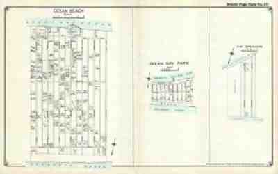
The U.S. Coast Guard Life Saving Station located in the community is illustrated as well. No other detail is included. Title: Ocean Beach. / Ocean Bay Park. / The Breakers. Services include deacidification cleaning flattening and backing.
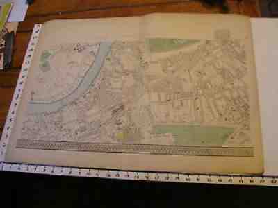
Find many great new & used options and get the best deals for Bacon's London 1880's map #10 Clapham Junction station, town meadows at the best online prices at eBay! Free shipping for many products!
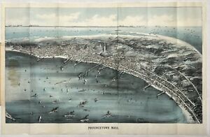
Selling a rare original 1910 Provincetown Bird’s Eye View pocket map.The map was published by Walker Lith. & Publishing Co., Boston Mass.Shows good detail of Provincetown street plan including: Provincetown Harbor, wharves, views of the monument, Clapps Pond, Race Point Light, Race Run and Race Point Life Saving Station. In the background it shows: Plymouth, Gurnet Light, Standish Monument, Duxbury Wireless Station, Blue Hills, Boston, Boston Light, Minot Light and the Boston Light Ship. Condition: - Very good overall condition with folds as issued. - Heavy cover with bank note paper map. - Glue appears on the left where it is attached to the cover. - see photos (may possibly be less evident when detached) - Cover can be detached or folded back for framing Measurements: (approx.) Map - Outside Paper 17.75” x 11.5” - Map Image 10.0” x 17.0” (unfolded) Cover 3.25” x 5.5” (folded)The map will be shipped flat and not folded.Please ask questions before purchasing ———————————— As noted on the Norman Leventhal Map and Education Center at the Boston Public in a northwesterly direction toward Cape Cod Bay and the distant Boston shoreline, this bird's eye view portrays Provincetown at a time when the town was transitioning from a community dependent on fishing to one whose economy and culture were increasingly tied to the annual influx of summer residents and a growing artists and writers community. The central focus of this view is most striking architectural feature, the Pilgrim Monument. This 252-foot tower was completed just as the view was published in 1910. Celebrating this locale's historic origins, the monument was built to commemorate the Mayflowers five-week stay at the tip of Cape Cod before the Pilgrims decided to shift their base to Plymouth Bay. The view also provides evidence of the community’s changing economy. Numerous wharves, a mixture of steam and sailing ships in the harbor, and three cold storage plants for processing fish; Consolidated Weir, Provincetown Cold Storage, and Fisherman's Cold Storage reflect the town’s reliance on maritime industries during the 19th century. On the other hand, the identification in the legend of several hotels (Pilgrim, New Central, Atlantic, Gifford, and Mt. Pleasant Houses) and the Star Theater foreshadow the town's developing tourist industry during the 20th century.”
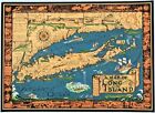
RARE ORIGINAL 1961 COURTLAND SMITH PICTORIAL MAP OF LONG ISLAND, NEW YORKDATE-1961, NOT ON MAPPUBLISHED BY-COURTLAND SMITHORIGINAL 1961 PICTORIAL MAP OF LONG ISLAND, NEW YORK. BEAUTIFULLY COLORED AND VERY RARE COURTLAND SMITH MAP OF LONG ISLAND AND VICINITY WITH TOWNSHIPS, COUNTY LINES, LIGHTHOUSE LOCATIONS AND LONG ISLAND SOUND. MAP IS SURROUNDED BY PICTURES OF HISTORICAL PLACES IN NEW YORK INCLUDING THE BROOKLYN BRIDGE, RUM ROW, WASHINGTON'S RETREAT FROM BROOKLYN IN 1776 AND THE FIRST SETTLEMENT IN BROOKLYN IN 1614. VARIOUS PICTURES ON MAP OF SHIPS, LIGHTHOUSES, BEACH GOERS AND CONEY ISLAND. ALSO SHOWN ARE FERRY LINES, PARKS AND RADIO STATIONS. STUNNING AND RARE HISTORICAL LONG ISLAND MAPMEASURES 27 X 19.5 INCHES ENTIRE SHEETVERY GOOD CONDITION, NEAR EXCELLENTMAP WILL BE SHIPPED IN A LARGE STURDY TUBE