Map Collectibles : Station Value Guide
Free Map Collectibles : station price guide. Find out how much your map collectibles : station are worth with current market values.
average value
$127.93
low
$10.51high
$3,200.00Example: "vintage basket", "rare ornament", "collectible plate"
Sold on eBay Jul 18, 2022
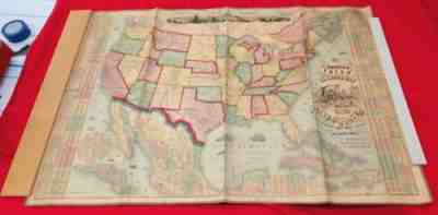
Antique original Map 1873 The American Union Railroad Map of the United States
OCLC locates only one example of the 1873 edition of the map (Yale). Not in Rumsey (who notes editions of 1871 and 1874 and also identifies the Warren Heckrotte Copy of the 1873 edition). Also, an elaborate title and view of a steam engine and train station have replaced the more subdued 1864 title.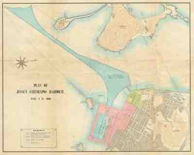
Sold on eBay Sep 15, 2021
1950s Map of Incheon Harbor, South Korea (Jinsen, Chemulpo, Jemulpo, Inchon)
This is an important and rare map from that period. Title: Plan of Jinsen (Chemulpo) Harbour. The plan details the sections already constructed, in progress, dredged and proposed by color coding. It notes important landmarks including the Jinsen railway station, landing pier, custom house, etc. along with topography.
Sold on eBay Oct 29, 2020
October 15,1863 Civil War Map For 2nd Battle Of Rappahannock Station Virginia
It is printed on the bottom right "Ed. Oct. 15, 1863". The Second Battle Of Rappahannock Station began 3 weeks later on November 7, 1863. It is printed on paper with hand cut edges, slightly crooked.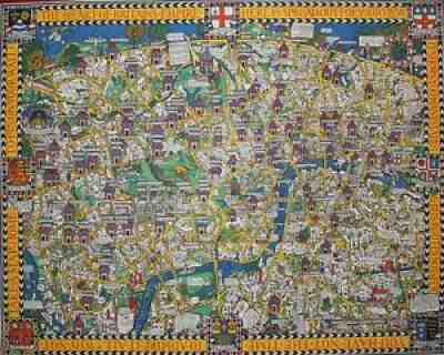
Sold on eBay Feb 16, 2018
ViNTAGE Original Gill Macdonald WONDERGOUND MAP of LONDON TOWN
"Macdonald Gill's primary coloured Wonderground map was published early in 1914 and was hung at every station. 1914 London, with its population of seven million, was the capital of the largest empire the world had ever seen.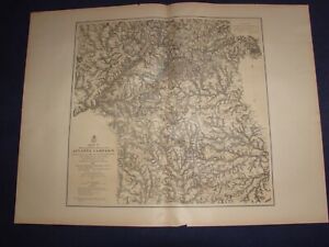
Sold on eBay October 28th, 2023
1874-77 5 Map Set Military Operations Atlanta Campaign Georgia Sherman Civil War
eBay Map[s] Illustrating the Military Operations of the Atlanta Campaign 1864 Compiled by the Authority of the Hon. the Secretary of War in the Office of the Chief of Engineers, U.S.A. [Set of 5 maps] [Georgia] by U.S. Army Corps of Engineers, Maj. Gen'l W. T. Sherman, Gen'l J. E. Johnston, and Gen'l J. B. Hood Complete set of 5 large sepia tinted lithographic maps, dated 1874-1877, with blue and red overprinting showing the lines of works of the United States and Confederate forces, and lines of march pursued by the separate armies, for illustrating the events of Sherman's Atlanta Campaign during the Spring and Summer of 1864; all with centerfold, as issued. Lithography by Julius Bien. An outstanding amount of detail and information is shown on these maps which were drawn from Union surveys and captured Confederate maps. Topography is rendered by finely drawn hachures which delineate the terrain in exquisite detail. Towns, roads and numerous individual homesites are shown, each identifying the landowner by name. Important battlefield sites of the campaign are shown, named and dated. The maps, with additional title information, include: Map I, This map embraces the region extending from the Tennessee River to the Oostanaula River and exhibits the works of the United States and Confederate forces...1875, 20 1/4 x 34 1/4 inches; Map II, This map includes the region from Resaca on the North to Ackworth on the south and exhibits the work of the United States and Confederate forces...1877, 25 x 27 1/2 inches; Map III,, This map includes the region extending from Rome, Kingston, Cassville on the north to include Dallas and Marietta on the south and the exhibits the works of the United States and Confederate forces...1876, 31 x 22 1/4 inches; Map IV, Embracing the region from Pine, Lost and Kennesaw Mountains south to include Atlanta and its environs, exhibiting the lines of operations at Pine, Lost and Kennesaw Mts., at Smyrna camp ground, along the Chattahoochie River, and in the investment of Atlanta...1874, 26 1/4 x 24 1/2 inches; and Map V, This map includes the region from the Chattahoochee River south to Jonesboro and Lovejoy's Station, and exhibits the works of the United States and Confederate forces, 26 x 25 inches. Condition: Light even age toning to paper. Paper is somewhat fragile with a short edge tear or two to each map limited to the blank margins, some closed with archival tissue tape on the back, and a few small edge chips. The original linen mounting strip, trimmed flush with paper surface, is still attached to the centerfold of all maps). All maps are clean and well preserved. A very good set.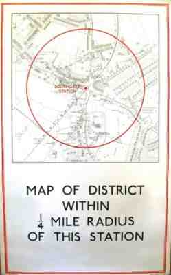
Sold on eBay Oct 07, 2022
LONDON TUBE POSTER: SOUTHGATE. Uncommon map, 1/4 mile around the station in 1933
[SOUTHGATE STATION] - â??MAP OF DISTRICT WITHIN 1/4 MILE RADIUS OF THIS STATIONâ??. 97 x 59 cm (map: 56 x 52 cm). Laid on linen as issued. Original outline colour. Excellent condition. Southgate station opened on 13 March 1933 on the second phase of the northern extension of the Piccadilly line from Finsbury Park to Cockfosters.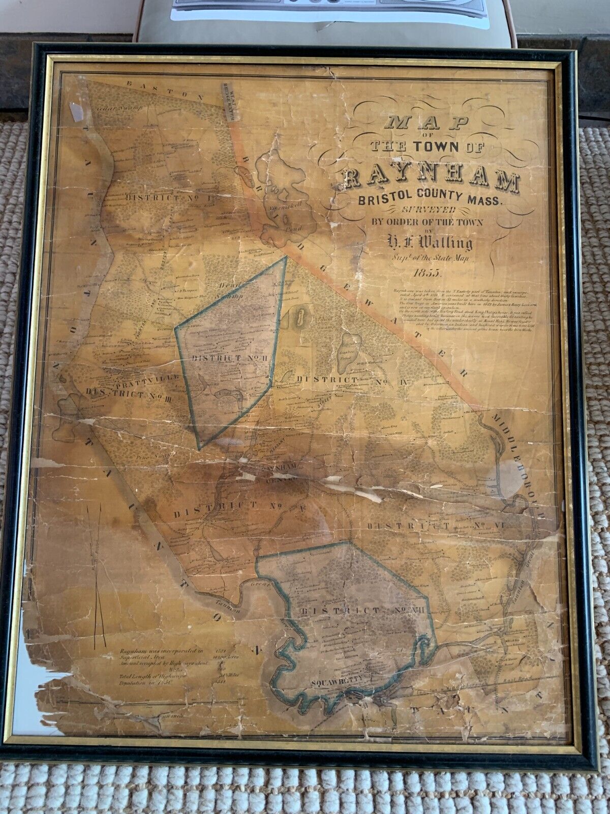
Sold on eBay March 25th, 2025
Antique 1855 Town Map Raynham MA Mass Massachusetts Henry Francis H F Walling
Antique 1855 (170 years old!!)Henry Francis WallingI love some of the script on this map: "The first forged in America was built here in 1652 by James and Henry Leonard and is now in constant operation.""On the north side of the fowling pond to King Phillips house. It was called Phillips hunting house because in the season most favorable for hunting he resided here but spent the winter chiefly at Mount Hope. He was finally shot by Alderman, an Indian, and his head was for some time kept in the cellar under the ancient Gothic house near the ironworks."1850 Population 1541This is currently framed in plexiglass. There are several cracks in the plexiglass.It's not properly mounted; there is about a half in of air gapping inside, which is allowing the map to gravity sink and bend/fold on itself. (aka it's not taped, pinned, etc.)Lower corner of the map missing. Several large cracks as evident in the pics.I am not a map guy, you should assume I know next to nothing about maps and ask any quantifying questions. Also - I am glad to ship as-in in this frame or rolled in a roll mailer. Please let me know your preference. If shipped as-in, I am worried that a few hard vertical bangs would put more gravity pressure on those floating map. That said - I will make sure to box as if this was as fragile as glass.Thanks :)Henry Francis WallingAdd Wikipedia, the free article includes a list of general references, but it lacks sufficient corresponding inline citations. Please help to improve this article by introducing more precise citations. (November 2021) (Learn how and when to remove this message)Henry Francis Walling (June 11, 1825 - April 8, 1889) was a notable American civil engineer and cartographer Walling was born in Burrillville, Rhode Island, where he was educated at public schools. After graduation he became an assistant librarian in the Providence Athenaeum, during which time he studied mathematics and surveying. He then entered the office of Samuel Barrett Cushing, a civil engineer in Providence, whose partner he became in 1846. He began topographic work in 1849, and prepared atlases containing full maps and scientific descriptions of most of the northern American states and the Dominion of Canada. After preparing at least 50 town maps in the Massachusetts vicinity, in 1855 he became the Commonwealth's Superintendent of the State Map. In 1856 he moved to New York City for its quality lithographers In 1867 Walling became chair of civil engineering in Lafayette, in which role he served for three years, but then resigned to accept an appointment as assistant in the Office of Coast Survey. He joined the newly-formed United States Geological Survey in 1883, and in 1884 was assigned to duty for the geodetic survey of Massachusetts in preparation of the state maps, on which work he was engaged at the time of his death.Walling was a Fellow of the American Association for the Advancement of Science and of the American Society of Civil Engineers Wallings died of a heart attack in Cambridge, needed] in 1889 [1]Raynham Massachusetts22 41°56?55?N Wikipedia, the free encyclopediaRaynham Town in Bristol County in 41°56?55?N • TypeOpen town meetingArea • Total20.9 sq mi (54.0 km2) • Land20.5 sq mi (53.1 km2) • Water0.4 sq mi (0.9 km2)Elevation81 ft (25 m)Population (2020) • Total15,142 • Density720/sq mi (280/km2)Time zoneUTC?5 (Eastern) • Summer (DST)UTC?4 (Eastern)ZIP Code02767Area code508/774FIPS code25 56060GNIS feature removed by eBay]Raynham (/?re?n?m/) is a town in Bristol County, Massachusetts, United States, located approximately 32 miles (51 km) south of Boston and 22 miles (35 km) northeast of Providence, Rhode Island. The population was 15,082 at the 2020 census.[1] It has one village, Raynham Center History[edit]The area that is now Raynham was settled in 1639 as a part of Taunton, and was founded by Elizabeth Pole, the first woman to found a town in America.It was to that area three years earlier that Roger Williams, proponent of separation of church and state, of paying Indians for land acquired and abolishing slavery, had escaped, traveling 55 miles during a January blizzard. He was fleeing a conviction for sedition and heresy of the General Court of Salem, and it was here that the local Wampanoags offered him shelter at their winter camp. Their Sachem Massasoit hosted Williams for the three months until spring.In 1652, bog iron was found along the Two Mile (Forge) River. Soon after, the Taunton Iron Works was established by residents James and Henry Leonard. It was the first successful iron works established in what was then Plymouth Colony, and operated from 1656 to 1876.[2] It was not the "First Iron Works in America", as proclaimed on the Town's official seal, having been predated by the Saugus and Braintree iron works. The success of the Taunton Iron Works, however, led to the establishment of other iron works throughout the colonies Raynham played a key part in King Philip's War. The Leonards had forged a friendship before the war began with King Philip, who lived in the area. It is said that Philip agreed to spare the town from the mass destruction if the Leonards repaired his troops' weapons in their iron forge.The eastern end of Taunton was separated from that town and incorporated as Raynham on April 2, 1731, named after the English village of Raynham in the county of Norfolk, England. Many ships' hulls were built along the Taunton River in Raynham, which were sailed down the river towards Fall River and Narragansett Bay for final fittings. The town also had other small manufacturing industries, but for the most part it was known for its rural and agrarian base [3]Transportation[edit]The intersection of Interstate 495 and Massachusetts Route 24, a four-lane divided highway, is located at the town's border with Bridgewater. Additionally, U.S. Route 44, Massachusetts Route 104 and Route 138 pass through the town. Route 24 has one exit which gives access to the town, Exit 20 (Route 44), and there is also a Raynham exit on Interstate 495: Exit 22 (Route 138).Raynham is one of the towns covered by the Greater Attleboro Taunton Regional Transit Authority (GATRA) bus service. The MBTA Commuter Rail's nearest stop is in neighboring Bridgewater, on the Middleborough Lakeville Line. The second phase of the MBTA's South Coast Rail project is proposed to extend the existing Stoughton Line south through Easton and Raynham to Fall River and New Bedford. The line would make a station stop at the proposed Raynham Place Station, which would be located next to Raynham Park.The nearest local airport is in Taunton; commercial air service exists at Logan International Airport in Boston and at T. F. Green Airport in Providence, Rhode Island Demographics[edit]Historical populationYearPop ± 18501 541— 18601 746 13 3 18701 713?1 9 18801 681?1 9 18901 340?20 3 19001 540 14 9 19101 725 12 0 19201 695?1 7 19302 136 26 0 19402 141 0 2 19502 426 13 3 19604 150 71 1 19706 705 61 6 19809 085 35 5 19909 867 8 6 200011 739 19 0 201013 383 14 0 202015 142 13 1 202315 649 3 3 Source: United States census records and Population Estimates Program data [4][5][6][7][8][9][10][11][12][13][14]As of the census[15] of 2000, there were 11,739 people, 4,143 households, and 3,231 families residing in the town. The population density was 572.7 inhabitants per square mile (221.1/km2). There were 4,209 housing units at an average density of 205.3 per square mile (79.3/km2). The racial makeup of the town was 96.54% White, 1.04% African American, 0.06% Native American, 0.69% Asian, 0.03% Pacific Islander, 0.71% from other races, and 0.94% from two or more races. Hispanic or Latino of any race were 0.83% of the population There were 4,143 households, out of which 36.7% had children under the age of 18 living with them, 63.8% were married couples living together, 10.6% had a female householder with no husband present, and 22.0% were non-families. Of all households 17.9% were made up of individuals, and 8.5% had someone living alone who was 65 years of age or older. The average household size was 2.80 and the average family size was 3.18.In the town, the population was spread out, with 25.7% under the age of 18, 6.8% from 18 to 24, 29.9% from 25 to 44, 24.7% from 45 to 64, and 13.0% who were 65 years of age or older. The median age was 38 years. For every 100 females, there were 91.8 males. For every 100 females age 18 and over, there were 88.5 males.The median income for a household in the town was $60,449, and the median income for a family was $68,354. Males had a median income of $46,954 versus $31,760 for females. The per capita income for the town was $24,476. About 3.2% of families and 4.1% of the population were below the poverty line, including 3.7% of those under age 18 and 9.0% of those age 65 or over Government[edit]The town is part of the Massachusetts House of Representatives 8th Plymouth district, which includes Bridgewater and part of Easton. It is also part of the Massachusetts Senate's 1st Plymouth and Bristol district, which includes Berkley, Bridgewater, Carver, Dighton, Marion, Middleborough, Taunton and Wareham. Raynham is patrolled by Massachusetts State Police#Troop D (Southeast District), 4th Barracks (located in Middleborough). On the national level, the town is part of Massachusetts's 4th congressional district, which is represented by Jake Auchincloss. The state's senior (Class I) Senator is Elizabeth Warren, and the state's junior (Class II) Senator is Ed Markey.Raynham is governed by an open town meeting and elects a board of selectmen, which directs a full-time town administrator. Patricia Riley, Joseph Pacheco and Kenneth Collins are the town elected selectmen. The Town Administrator is Gregory Barnes. The three members of the board of selectmen are elected at large on a staggered schedule. Basic services are centered around the town hall located at Raynham Center, including the police station and fire department. There are two post offices, located near Raynham Center and along Route 138 near North Raynham. The town also operates the Borden Colony Recreation Area, and there is a small State Forest in the town. The presidential results were mostly democratic until 2008, when the town narrowly voted for republican John McCain over democrat Barack Obama. It was also republican in 2012 and 2016 and it was democratic in 2020. In the 2024 United States presidential election, Republican Donald Trump received 4,694 votes, while Democrats Kamala Harris received 4,059 votes.Raynham presidential election results[16] partiesTotal VotesMargin202049 62 4,37248.16% 4,2432.22% 1968 8111 46 201643 93 3,32750.25% 3,8065.82% 4417 5746 32 201246 21 3,22252.46% 3,6581.33% 936 9736 25 200847 49 3,33650.17% 3,5242.33% 1647 0242 68 200450 75 3,22348.59% 3,0860.66% 426 3512 16 200054 53 3,12840.17% 2,3045.30% 3045 73614 37 199654 91 2,75132.40% 1,62312.69% 6365 01022 51 199235 56 1,83934.25% 1,77130.19% 1 5615 1711 32 198839 67 1,82059.00% 2,7071.33% 614 58819 33 198433 61 1,41865.99% 2,7840.40% 174 21932 38 198031 59 1,31952.49% 2,19215.92% 6654 17620 91 197648 00 1,77848.95% 1,8133.05% 1133 7040 94 197243 02 1,24256.46% 1,6300.52% 152 88713 44 196847 68 1,31546.59% 1,2855.73% 1582 7581 09 196465 63 1,57534.08% 8180.29% 72 40031 54 196043 75 90056.15% 1,1550.10% 22 05712 40 195624 61 40573.39% 1,2082.00% 331 64648 78 195230 67 42369.18% 9540.15% 21 37938 51 194839 64 44459.02% 6611.34% 151 12019 38 194434 45 31865.01% 6000.54% 592330 55 194033 50 33866.40% 6700.10% 11 00932 90 Education[edit]Raynham Public Library, with World War II, Civil War and World War I memorials on lawnRaynham belongs to the Bridgewater Raynham Regional School District. There are three schools in Raynham: L.B. Merrill Elementary School, housing Pre Kindergarten through first grade, LaLiberte Elementary School, housing second through fourth grades, and Raynham Middle School, housing fifth through eighth grades. Bridgewater Raynham Regional High School, located in Bridgewater, houses ninth through twelfth grades. The high school athletics teams are nicknamed the Trojans, and the primary colors are red and white, with blue trim. The BR School Committee consists of eight members. High school students may also attend Bristol Plymouth Regional Technical School, located in Taunton, or Bristol County Agricultural High School in Dighton. Students may also select to attend private and parochial schools in the neighboring towns.In recent years, discussions have taken place regarding the possibility of the withdrawal of Raynham's three pre kindergarten eighth grade schools from the Bridgewater Raynham Regional School District. The town cites an unfair funding formula, as well as Bridgewater's inability to fully fund the district, as its reasons for the proposal. However, on November 17, 2010, the proposal was unanimously defeated by voters at a special town meeting, thereby maintaining the current regional system Recreation[edit]Johnston Memorial ParkRaynham Park is located in Raynham and holds the world record for largest annual handle.[17] All racing at the park was formally ended on January 1, 2010, after the state election banned all greyhound racing. The building remains to host simulcast racing. In 2011, the Wampanoag Indian tribe indicated an interest in establishing a "Racino"-style gaming casino at the Raynham dog track,[18] but in August 2011 talks broke down [19]Religion[edit]Wat is host to several religious organizations of various religious denominations. Among the largest is St. Ann's Roman Catholic Church, Steeple Point Church (Home to the Raynham Food Basket), Calvary Chapel contemporary evangelical church, Lutheran Church of the Way, First Congregational Stone Church, and Father's House Family Protestant Church. Raynham is also home to Wat Nawamintararachutis opened in 2014 as the largest Thai Buddhist temple outside of Thailand. [20]Notable C. Anderson, received the United States military's highest decoration for valor, the Medal of Honor, for his action of capturing the battle flag of the 27th South Carolina regiment at the battle of Wheldon Railroad (also known as the Battle of Globe Tavern) near Petersburg, Virginia on September 6, 1864. Anderson was a member of the 18th Massachusetts Volunteer Regiment which was eventually transferred into the 32nd Regiment Massachusetts Volunteer Infantry which saw action in many of the major battles of the eastern campaign of the Civil War.Toby Gilmore, a former slave, volunteered in 1776 to serve in the Continental Army in place of his master who had been drafted. He served under General George Washington as tent master and is believed to have crossed the Delaware with him and spent the winter at Valley ForgeJared C. Monti, received the United States military's highest decoration for valor, the Medal of Honor, for his actions in Afghanistan attempting to rescue a wounded American soldier while under fire from enemy insurgents. Monti was killed in action in 2006 during this third attempt to rescue SPC Brian J. Bradbury. His actions are memorialized in the book "See You on the High Ground" written by Len Sandler, childhood friend of Monti's father.[21] Also, the story of his father Paul C. Monti driving in Jared's truck after his death has been memorialized in the 2012 Country Western song "I Drive Your Truck" by Lee Brice. The song won The Academy of Country Music and The Country Music Association awards for Song of the Year.[22]Gil Santos, the longtime radio play-by-play announcer for the New England Patriots of the National Football League
Sold on eBay May 9th, 2025
VTG ANTIQUE 1910 WALL MAP OF PENNSYLVANIA STATION NEW YORK CITY NY HAWLEY
This is an antique wall map of Pennsylvania Station in New York City from 1910. It depicts the layout of the station and the surrounding area at the time it was created. This map is a great piece of history for collectors of NYC. The map itself measures 35 x 60 inches with the dowels extending a little further. Rolled up it has a length of 63 inches. This map is 115 years old. It does show wear and tear with creases, stains and small tears. Please see last few photos. Please look close and ask questions before bidding. Thank you for looking and please take time to check out our other auctions!!! SHIPPING. Approximately 90% of our material is re-used or recycled! Our US shipping and handling charges are stated individually in each auction and are determined by weight, size, and packing material. Please check our feedback from our satisfied customers. Payment is expected within 3 days of auction closing and feedback is given accordingly. Normally purchases will be mailed within 1-4 days after receipt of payment. RETURN POLICY Your satisfaction is very important to us. If we have made an error in listing or have misrepresented an item, please contact us within 14 days of receiving the item for a refund. Buyer pays return shipping fees. A refund will be issued after the item has been returned. A 15% re-stocking fee will be applied If the item is returned with no fault or error on our behalf We just recently opened this second store. We have been successfully operating for 13 years under our other store, 1manstrash2011. Please take a moment to check out all of those listings.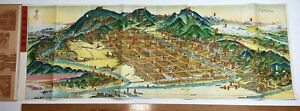
Sold on eBay November 30th, 2023
RARE Bird's-eye-view Kyoto Japanese - SUPER Map 1947 from WWII Japan Occupation
eBay RARE Original Map Bird's Eye View of Kyoto & Environs in Colorful Wrapsca 1947 For offer, an ORIGINAL map. Fresh from a local estate - never offered on the market until now. Vintage, Old, antique, Original - NOT a Reproduction - Guaranteed !! This interesting map came from the belongings of a WWII soldier who brought this back home after the war / occupation. Great detail! Bird's-eye view, pictorial map of Kyoto folded into heavy paper covers. Map showing buildings, trees, parks, landmarks, roads, railroads, rivers, etc. Title and text, tourist information in English and Japanese and place names in Japanese. Folding travel / tourist map. Measures 29 1/4 x 10 1/2 inches. In very condition. Map is excellent. Light foxing to cover wraps. Displays very nicely. Please see photos for details. If you collect Japanese history, 20h century geography, atlas, etc., this is one you will not see again. A nice piece for your paper / ephemera collection. Perhaps some genealogy research information as well. Combine shipping on multiple bid wins! 2603 Kyoto ( ?kjo?to? ;[3] Japanese: ??, Ky?to [k?o??to] (About this soundlisten)), officially Kyoto City (???, Ky?to-shi, (About this soundlisten)), is the capital city of Kyoto Prefecture in Japan. Located in the Kansai region on the island of Honshu, Kyoto forms a part of the Keihanshin metropolitan area along with Osaka and Kobe. As of 2021, the city has a population of 1.45 million, making up 57% of the prefecture's total population. The city is the cultural anchor of a substantially larger metropolitan area known as Greater Kyoto, a metropolitan statistical area (MSA) home to a census estimated 3.8 million people in 2020 and ranking as the second MSA in the Kansai region OverviewKyoto is one of the oldest municipalities in Japan, having been chosen in 794 as the new seat of Japan's imperial court by Emperor Kanmu. The original city, named Heian-ky?, was arranged in accordance with traditional Chinese feng shui following the model of the ancient Chinese capital of Chang an Luoyang The emperors of Japan ruled from Kyoto in the following eleven centuries until 1869. It was the scene of several key events of the Muromachi period, Sengoku period, and the Boshin War, such as the ?nin War, the Honn?-ji Incident, the Kinmon incident and the Battle of Toba–Fushimi. Upon the Imperial Court victory over the Tokugawa shogunate, the capital was relocated to Tokyo after the Meiji Restoration. The modern municipality of Kyoto was established in 1889. The city was spared from large-scale destruction during World War II and as a result, its prewar cultural heritage has mostly been preserved.Kyoto is considered the cultural capital of Japan and a major tourist destination. It is home to numerous Buddhist temples, Shinto shrines, palaces and gardens, some of which are listed collectively by UNESCO as a World Heritage Site. Prominent landmarks include the Kyoto Imperial Palace, Kiyomizu-dera, Kinkaku-ji, Ginkaku-ji and the Katsura Imperial Villa. Kyoto is also a center of higher learning, with Kyoto University being an institution of international renown NameEtymologyIn Japanese, Kyoto was previously called Ky? (?), Miyako (?), or Ky? no Miyako (???). In the 11th century, the city was renamed "Ky?to" (??, "capital city"), from the Middle Chinese kiang-tuo (cf. Mandarin j?ngd?).[4] After the city of Edo was renamed "T?ky?" (??, meaning "Eastern Capital") in 1868 and the seat of the emperor was moved there, Kyoto was for a short time known as "Saiky?" (??, meaning "Western Capital"). Kyoto is also sometimes called the thousand-year capital (????) The National Diet never officially passed any law designating a capital.[5] Foreign spellings for the city's name have included Kioto, Miaco and Meaco, utilized mainly by Dutch cartographers. Another term commonly used to refer to the city in the pre-modern period was Keishi (??), capital [6]GeographyKyoto seen from Mount Atago in the northwest corner of the is located in a valley, part of the Yamashiro (or Kyoto) Basin, in the eastern part of the mountainous region known as the Tamba highlands. The Yamashiro Basin is surrounded on three sides by mountains known as Higashiyama, Kitayama and Nishiyama, with a height just above 1,000 meters (3,281 ft) above sea level. This interior positioning results in hot summers and cold winters. There are three rivers in the basin, the Ujigawa to the south, the Katsuragawa to the west, and the Kamogawa to the east. Kyoto City takes up 17.9% of the land in the prefecture with an area of 827.9 square kilometers (319.7 sq mi).The original city was arranged in accordance with traditional Chinese feng shui following the model of the ancient Chinese capital of Chang an Luoyang The Imperial Palace faced south, resulting in Uky? (the right sector of the capital) being on the west while Saky? (the left sector) is on the east. The streets in the modern-day wards of Nakagy?, Shimogy?, and Kamigy?-ku still follow a grid pattern.Today, the main business district is located to the south of the old Imperial Palace, with the less-populated northern area retaining a far greener feel. Surrounding areas do not follow the same grid pattern as the center of the city, though streets throughout Kyoto share the distinction of having names.Kyoto sits atop a large natural water table that provides the city with ample freshwater wells. Due to large-scale urbanization, the amount of rain draining into the table is dwindling and wells across the area are drying at an increasing rate ClimateKyoto has a humid subtropical climate (Köppen Cfa), featuring a marked seasonal variation in temperature and precipitation. Summers are hot and humid, but winters are relatively cold with occasional snowfall. Kyoto's rain season begins around the middle of June and lasts until the end of July, yielding to a hot and sunny latter half of the summer. Kyoto, along with most of the Pacific coast and central areas of Japan is prone to typhoons during September and October Historically Kyoto was the largest city in Japan, later surpassed by Osaka and Edo (Tokyo) towards the end of the 16th century. In the pre-war years, Kyoto traded places with Kobe and Nagoya ranking as the 4th and 5th largest city. In 1947, it went back to being 3rd. By 1960 it had fallen to 5th again, and by 1990 it had fallen to 7th. As of 2015, it has been ranked the 9th largest city in Japan.Greater KyotoSee also: Greater KyotoThe concentration of population to the capital city area is 55%, which is highest among the prefectures. The economic difference between the coastal area and inland area including Kyoto basin is significant. Encompassing ¥10.12 trillion, Kyoto MEA has the fourth-largest economy in the country in 2010 [10]HistorySee also: Timeline of archeological evidence suggests human settlement in the area of Kyoto began as early as the Paleolithic period,[11] although not much published material is retained about human activity in the region before the 6th century, around which time the Shimogamo Shrine is believed to have been established GalleryShimogamo Shrine?Kamo Shrine? Kamigamo Shrine?Kamo Shrine?Heian ky?Main article: Heian ky?During the 8th century, when powerful Buddhist clergy became involved in the affairs of the imperial government, Emperor Kanmu chose to relocate the capital in order to distance it from the clerical establishment in Nara. His last choice for the site was the village of Uda, in the Kadono district of Yamashiro Province [12]The new city, Heian-ky? (???, "tranquility and peace capital"), a scaled replica of the then Chinese Tang dynasty capital Chang'an,[13] became the seat of Japan's imperial court in 794, beginning the Heian period of Japanese history. Although military rulers established their governments either in Kyoto (Muromachi shogunate) or in other cities such as Kamakura (Kamakura shogunate) and Edo (Tokugawa shogunate), Kyoto remained Japan's capital until the transfer of the imperial court to Tokyo in 1869 at the time of the Imperial Restoration GalleryEmperor Kanmu Daidairi (palace in the center) and the cityscape of Heian ky?Middle AgesSengoku periodThe city suffered extensive destruction in the ?nin War of 1467–1477, and did not really recover until the mid-16th century. During the ?nin War, the shugo collapsed, and power was divided among the military families.[14] Battles between samurai factions spilled into the streets, and came to involve the court nobility (kuge) and religious factions as well. Nobles' mansions were transformed into fortresses, deep trenches dug throughout the city for defense and as firebreaks, and numerous buildings burned. The city has not seen such widespread destruction since.In the late 16th century, Toyotomi Hideyoshi reconstructed the city by building new streets to double the number of north–south streets in central Kyoto, creating rectangle blocks superseding ancient square blocks. Hideyoshi also built earthwork walls called odoi (???) encircling the city. Teramachi Street in central Kyoto is a Buddhist temple quarter where Hideyoshi gathered temples in the city Gallery?nin War Nij? Castle Toyotomi Hideyoshi JurakudaiEarly modern periodEdo the Edo period, the economy of the city flourished as one of three major cities in Japan, the others being Osaka and Edo.GalleryMap of Heian-ky?, 1696 Sanj? ?hashi (The Fifty-three Stations of the T?kaid?) Perspective Pictures of Places in Japan: Sanj?sangen d? in KyotoToyoharu, c. 1772–1781 Fushimi CastleLate modern periodMeiji periodThe Hamaguri rebellion of 1864 burnt down 28,000 houses in the city which showed the rebels' dissatisfaction towards the Tokugawa Shogunate.[15] The subsequent move of the emperor to Tokyo in 1869 weakened the economy. The modern city of Kyoto was formed on April 1, 1889. The construction of Lake Biwa Canal in 1890 was one measure taken to revive the city. The population of the city exceeded one million in 1932 [8]GalleryKinmon incident Battle of Toba–Fushimi (Boshin War) View of Kyoto from beside the Hond? of Kiyomizudera. – 1879[16] Nanzenji historyModern KyotoKyoto International Conference CenterThere was some consideration by the United States of targeting Kyoto with an atomic bomb at the end of World War II because, as an intellectual center of Japan, it had a population large enough to possibly persuade the emperor to surrender.[17] In the end, at the insistence of Henry L. Stimson, Secretary of War in the Roosevelt and Truman administrations the city was removed from the list of targets and replaced by Nagasaki. The city was largely spared from conventional bombing as well, although small-scale air raids did result in casualties.[18] During the occupation, the U.S. Sixth Army and I Corps were headquartered in Kyoto.[19]As a result, Kyoto is one of the few Japanese cities that still have an abundance of prewar buildings, such as the traditional townhouses known as machiya. However, modernization is continually breaking down the traditional Kyoto in favor of newer architecture, such as the Ky?to Station complex.Kyoto became a city designated by government ordinance on September 1, 1956. In 1997, Kyoto hosted the conference that resulted in the protocol on greenhouse gas emissions (United Nations Framework Convention on Climate City HallKyoto City is governed by the directly elected mayor of Kyoto and the Kyoto City Assembly. Following the 2020 Kyoto mayoral election, independent Daisaku Kadokawa was re-elected for the fourth time, supported by the Liberal Democratic Party, Komeito, Constitutional Democratic Party, and Democratic Party for the People. The legislative city assembly has 67 elected members.Kyoto City group name Affiliated political party/parties Number of seatsLiberal Democratic Party Kyoto City Assembly Liberal Democratic Party 22Japanese Communist Party Kyoto City Assembly Japanese Communist Party 18Komeito Kyoto City Assembly Komeito 10Democratic Civic Forum Kyoto City Assembly CDP and DPP 6Kyoto Party City Assembly Kyoto Party (regional party) 5Japan Innovation Party Kyoto City Assembly Japan Innovation Party 4Independent 1Vacant 1Elections2008 Kyoto mayoral election2012 Kyoto mayoral election2016 Kyoto mayoral election2020 Kyoto mayoral relationsSee also: List of twin towns and sister cities in JapanKyoto, having been the capital city of Japan, a seat of learning and culture, has long established ties with other great cities around the world. Many foreign scholars, artists and writers have stayed in Kyoto over the centuries.Twin towns – Sister citiesThe city of Kyoto has sister-city relationships with the following States Boston, United States (since June 1959)Germany Cologne, Germany (since May 1963)Italy Florence, Italy (since September 1965)Mexico Guadalajara, Mexico (since October Kyiv, Ukraine (since September 1971)Czech Republic Prague, Czech Republic (since April 1996)[22]China Xi'an, China (since May 1974, friendship City)Croatia Zagreb, Croatia (since October 1981)Partner citiesIn addition to its sister city arrangements which involve multi-faceted cooperation, Kyoto has created a system of "partner cities" which focus on cooperation based on a particular topic. At present, Kyoto has partner-city arrangements with the following cities:[23]Brussels Belgium (since April 2006)Hu?, Vietnam (since February 2013)Istanbul, Turkey (since June 2013)Jinju, South Korea (since March 1999)Konya, Turkey (since December 2009)Paris, France (since June 1958)[24]Qingdao China (since August 2012)Quebec City, Canada (since May 2016)Tainan, Taiwan (since June 2021)Varanasi, India (since August 2014)[25]Vientiane Laos (since November 2015)Yilan City, Taiwan (since August Economic CenterNintendo main headquartersGDP (PPP) per US$1975 5,3241980 9,5231985 13,8701990 20,4131995 23,6272000 26,9782005 32,1892010 36,3062015 41,410The key industry of Kyoto is information technology and electronics: the city is home to the headquarters of Nintendo, Intelligent Systems, SCREEN Holdings,[28] Tose, Hatena, Omron,[29] Kyocera, Shimadzu Corp.,[30] Rohm,[31] Horiba,[32] Nidec Corporation [33] Nichicon,[34] Nissin Electric,[35] and GS Yuasa.Tourists are hugely fond of Kyoto, contributing significantly to its economy. The cultural heritage sites of Kyoto are constantly visited by school groups from across Japan, and many foreign tourists also stop in Kyoto. In 2014, the city government announced that a record number of tourists had visited Kyoto,[36] and it was favored as the world's best city by U.S. travel magazines [37]Traditional Japanese crafts are also major industry of Kyoto, most of which are run by artisans in their plants. Kyoto's kimono weavers are particularly renowned, and the city remains the premier center of kimono manufacturing. Such businesses, vibrant in past centuries, have declined in recent years as sales of traditional goods stagnate.Sake brewing is Kyoto's traditional industry. Gekkeikan and Takara Holdings are major sake brewers headquartered in Kyoto.Other notable businesses headquartered in Kyoto includes Aiful, Ishida, MK,[38] Nissen Holdings, Oh-sho, Sagawa Express, Volks and Wacoal.The pandemic caused a drop in revenue from the tourism sector and put the city in a precarious financial situation. The mayor acknowledged in 2021 "the possibility of bankruptcy in the next decade" and announced job cuts in the administration and cuts in social assistance, including reductions in funding for home care. Analysts note, however, that Kyoto's financial problems predate the pandemic [39]EducationColleges and UniversitySee also: Higher education in JapanHome to 40 institutions of higher education, Kyoto is one of the academic centers in Japan.[40] Kyoto University is considered to be one of the top national universities nationwide. According to the Times Higher Education top-ranking university, Kyoto University is ranked the second university in Japan after University of Tokyo, and 25th overall in the world as of 2010.[41] The Kyoto Institute of Technology is also among the most famous universities in Japan and is considered to be one of the best universities for architecture and design in the country. Popular private universities, such as Doshisha University and Ritsumeikan University are also located in the city.Kyoto also has a unique higher education network called the Consortium of Universities in Kyoto, which consists of three national, three public (prefectural and municipal), and 45 private universities, as well as the city and five other organizations. The combination does not offer a degree, but offers the courses as part of a degree at participating universities [42]In addition to Japanese universities and colleges, selected American universities, such as Stanford, also operates in the city for education and research. Kyoto Consortium for Japanese Studies (KCJS) is a combination of 14 American universities that sponsors a two-semester academic program for undergraduates who wish to do advanced work in Japanese language and cultural studies [43]TransportationSee also: Transport in Airport express Haruka at Ky?to also: Kansai International Airport and Itami AirportAlthough Kyoto does not have its own large commercial airport, travelers can get to the city via nearby Itami Airport, Kobe Airport or Kansai International Airport. The Haruka Express operated by JR West carries passengers from Kansai Airport to Ky?to Station in 73 minutes [44]Osaka Airport Transport buses connect Itami Airport and Ky?to Station Hachijo Gate in 50 minutes and cost 1,310 yen (as of 2017) for a one-way trip.[45] Some buses go further, make stops at major hotels and terminals in the downtown area.Other airports located further from the city is Chubu Centrair International Airport located 154 km away from the city RailwaysSee also: Keihan Electric Railway, Hankyu Railway, Kintetsu Railway, Keifuku Electric Railroad, and Eizan Electric RailwayInside Ky?to StationJust like other major cities in Japan, Kyoto is well served by rail transportation systems operated by several different companies and organizations. The city's main gateway terminal, Ky?to Station, which is one of the most popular stations in the country, connects the T?kaid? Shinkansen bullet train Line (see below) with five JR West lines, a Kintetsu line and a municipal subway line.The Keihan, the Hankyu, and other rail networks also offer frequent services within the city and to other cities and suburbs in the Kinki region.There is a Railway Heritage site in Kyoto, where visitors can experience the range of Japanese railways in the Kyoto Railway Museum (formerly Umekoji Steam Locomotive Museum, situated about the roundhouse )High speed railMain articles: T?kaid? Shinkansen and Sany? ShinkansenSee also: Central Japan Railway Company and West Japan Railway at Kyoto StationThe T?kaid? Shinkansen operated by JR Central provides high-speed rail service linking Kyoto with Nagoya, Yokohama and Tokyo to the east of Kyoto and with nearby Osaka and points west on the San'y? Shinkansen, such as Kobe, Okayama, Hiroshima, Kitakyushu, and Fukuoka. The trip from Tokyo takes about two hours and eighteen minutes. From Hakata in Fukuoka, Nozomi takes you to Kyoto in just over three hours. All trains including Nozomi stop at Ky?to Station, serving as a gateway to not only Kyoto Prefecture but also northeast Osaka, south Shiga and north Nara Conventional linesWest Japan Railway Company?JR Main Line?JR Kyoto Line?Biwako Line?San'in Main Line?Sagano Line?Kosei LineNara Kyoto Main LineHankyu Arashiyama LineKeihan Electric Main LineKeihan ?t? LineKeihan Uji LineKeihan Keishin LineKintetsu Kyoto LineSagano Scenic RailwaySagano Scenic LineSubwaysAn express service bound for Kokusaikaikan Station of the Karasuma Line is running on Kintetsu Kyoto LinePlatform screen doors at Higashiyama Station of the T?zai LineMain article: Kyoto Municipal SubwayThe Kyoto Municipal Transportation Bureau operates the Kyoto Municipal Subway consisting of two lines: the Karasuma Line and the T?zai Line.Karasuma LineMain article: Karasuma LineThe Karasuma Line is colored green, and its stations are given numbers following the letter "K".The line has following stations, from north to south: Kokusaikaikan (terminal) and Matsugasaki in Saky?-ku; Kitayama and Kita?ji in Kita-ku; Kuramaguchi and Imadegawa in Kamigy?-ku; Marutamachi and Karasuma Oike in Nakagy?-ku; Shij?, Goj? and Ky?to in Shimogy?-ku; Kuj? and J?j? in Minami-ku; and Kuinabashi and Takeda (terminal) in Fushimi ku Between Kita?ji and J?j?, trains run beneath the north–south Karasuma Street (???, Karasuma-dori), hence the name. They link to the other subway line, the T?zai Line, at Karasuma Oike. They also connect to the JR lines at Ky?to Station and the Hankyu Kyoto Line running cross-town beneath Shij? Street at the intersection of Shij? Karasuma, Kyoto's central business district. At Shij? Karasuma, the subway station is named Shij?, whereas Hankyu's station is called Karasuma.The Transportation Bureau and Kintetsu jointly operate through services, which continue to the Kintetsu Kyoto Line to Kintetsu Nara Station in Nara. The Karasuma Line and the Kintetsu Kyoto Line connect at Kyoto and Takeda. All the stations are located in the city proper.Tozai LineMain article: T?zai Line (Kyoto)The T?zai Line is colored vermilion, and its stations are given numbers following the letter "T". This line runs from the southeastern area of the city, then east to west (i.e. t?zai in Japanese) through the Kyoto downtown area where trains run beneath the three east–west streets: Sanj? Street (???, Sanj?-dori), Oike Street (???, Oike-dori) and Oshik?ji Street (????, Oshik?ji dori) The line has following stations, from east to west: Rokujiz? (terminal) in Uji; Ishida and Daigo in Fushimi-ku; Ono, Nagitsuji, Higashino, Yamashina and Misasagi in Yamashina-ku; Keage, Higashiyama and Sanj? Keihan in Higashiyama-ku; Kyoto Shiyakusho-mae, Karasuma Oike, Nij?j?-mae, Nij? and Nishi?ji Oike in Nakagy?-ku; and Uzumasa Tenjingawa (terminal) in Uky?-ku.The Keihan Keishin Line has been integrated into this line, and thus Keihan provides through services from Hama?tsu in the neighboring city of ?tsu, the capital of Shiga Prefecture.The T?zai Line connects to the Keihan lines at Rokujiz?, Yamashina, Misasagi and Sanj? Keihan, to the JR lines at Nij?, Yamashina and Rokujiz?, and to the Keifuku Electric Railroad at Uzumasa Tenjingawa. All the stations except Rokujiz? are located in Kyoto TramwaysKeifuku Electric RailroadKeifuku Arashiyama Main LineKeifuku Kitano LineEizan Electric RailwayEizan Main LineEizan Kurama LineBusesA typical Kyoto Municipal BusKyoto's municipal bus network is extensive. Private carriers also operate within the city. Many tourists join commuters on the public buses, or take tour buses. Kyoto's buses have announcements in English and electronic signs with stops written in the Latin alphabet. Buses operating on routes within the city, the region, and the nation stop at Ky?to Station. In addition to Ky?to Station, bus transfer is available at the intersections of Shij? Kawaramachi and Sanj? Keihan. The intersection of Karasuma Kita?ji to the north of downtown has a major bus terminal serving passengers who take the Karasuma Line running beneath Karasuma Street, Kyoto's main north–south street RoadsShij? StreetKyoto and Karasuma Street seen from Kyoto Kyoto's ancient lanes, one-way system is prevalent and necessary for preservation of its character. The city is connected with other parts of Japan by the Meishin Expressway, which has two interchanges in the city: Kyoto Higashi (Kyoto East) in Yamashina-ku and Kyoto Minami (Kyoto South) in Fushimi-ku. The Kyoto-Jukan Expressway connects the city to northern regions of Kyoto Prefecture. The Daini Keihan Road is a new bypass (completed in 2010) to Osaka.Japan National RouteAlthough Greater Kyoto has fewer toll-highways than other comparable Japanese cities, it is served with elevated dual and even triple carriageway national roads. As of 2018, only 10.1 kilometers (6.3 miles) of the Hanshin Expressway Kyoto Route is in operation [46]There are nine national highways in the city of Kyoto: Route 1, Route 8, Route 9, Route 24, Route 162, Route 171, Route 367, Route 477 and Route 478 CyclingCycling is a very important form of personal transportation in the city. The geography and scale of the city are such that the city may be easily navigated on a bicycle. There are five bicycle rental stations and 21 EcoStations in central Kyoto. Because of the large number of cyclists, permitted bicycle parking areas can be difficult to find.[47] Bicycles parked in non-permitted areas are impounded WaterwaysJapanese trade and haulage traditionally took place by waterways, minimally impacting the environment up until the highway-systems built by Shogunates. There are a number of rivers, canals and other navigable waterways in Kyoto. The Seta and Uji rivers, confluence into the (Yodo River), Kamogawa and Katsura river flow through Kyoto. Lake Biwa Canal was a significant infrastructural development. In present days, however, the waterways are no longer primarily used for passenger or goods transportation, other than limited sightseeing purpose such as Hozugawa Kudari boat on the Hozu River and Jukkoku bune sightseeing tour boat in Fushimi-ku area. Lake Biwa remains a popular place for recreational boating, also the site of a Birdman Rally where contraptions and contrivances are driven from land over the waterway TourismTourists on street near Kiyomizu deraSee also: Tourism in JapanKyoto contains roughly 2,000 temples and shrines [48]UNESCO World Heritage SiteSee also: Historic Monuments of Ancient Kyoto (Kyoto, Uji and Otsu Cities)About 20% of Japan's National Treasures and 14% of Important Cultural Properties exist in the city proper. The UNESCO World Heritage Site Historic Monuments of Ancient Kyoto (Kyoto, Uji and Otsu Cities) includes 17 locations in Kyoto, Uji in Kyoto Prefecture, and ?tsu in Shiga Prefecture. The site was designated as World Heritage in 1994 MuseumsUmekoji Steam Locomotive MuseumKyoto Botanical GardenKyoto Railway Museum (formerly Umekoji Steam Locomotive Museum)Onishi Seiwemon Museum Museum Kyoto Arashiyama Orgel Museum City Heiankyo Sosei-Kan Museum Municipal Museum of ArtKyoto City Archaeological Museum Art CenterThe Kyoto International Manga MuseumThe National Museum of Modern Art, KyotoThe Kyoto National Museum Kyoto University Museum Museum of Traditional Crafts Museum of Kyoto Kyoto Botanical Garden of Fine Arts Prefectural Insho-Domoto Museum of Fine Arts Museum of Art Museum Museum of History ?????)Sen oku Hakuko Kan Kyoto Studio Park Art Museum Cloisonne Museum of Kyoto Yurinkan Museum Tin Toy Museum Hosomi Museum Hashimoto Kansetsu Garden and Museum (???? Raku Museum Museum for World Peace of Ritsumeikan University Sans? Kyoto Kaleidoscope Museum tsukemono shop on Nishiki StreetAlthough ravaged by wars, fires, and earthquakes during its eleven centuries as the imperial capital, Kyoto was not entirely destroyed in World War II. It was removed from the atomic bomb target list (which it had headed) by the personal intervention of Secretary of War Henry L. Stimson, as Stimson wanted to save this cultural center, which he knew from his honeymoon and later diplomatic visits.[49][50] Kyoto has been, and still remains, Japan's cultural center.[51][52] The government of Japan plans to relocate the Agency for Cultural Affairs to Kyoto in 2023.A monk by the Katsura River in ArashiyamaPonto ch? StreetGeishas in KyotoWith its 2,000 religious places – 1,600 Buddhist temples and 400 Shinto shrines, as well as palaces, gardens and architecture intact – it is one of the best preserved cities in Japan. Among the most famous temples in Japan are Kiyomizu-dera, a magnificent wooden temple supported by pillars off the slope of a mountain; Kinkaku-ji, the Temple of the Golden Pavilion; Ginkaku-ji, the Temple of the Silver Pavilion; and Ry?an-ji, famous for its rock garden. The Heian Jing? is a Shinto shrine, built in 1895, celebrating the imperial family and commemorating the first and last emperors to reside in Kyoto. Three special sites have connections to the imperial family: the Kyoto Gyoen area including the Kyoto Imperial Palace and Sent? Imperial Palace, homes of the emperors of Japan for many centuries; Katsura Imperial Villa, one of the nation's finest architectural treasures; and Shugaku-in Imperial Villa, one of its best Japanese gardens. In addition, the temple of Sennyu-ji houses the tombs of the emperors from Shij? to K?mei.Other sites in Kyoto include Arashiyama, the Gion and Pontoch? geisha quarters, the Philosopher's Walk, and the canals that line some of the older streets.The "Historic Monuments of Ancient Kyoto" are listed by the UNESCO as a World Heritage Site. These include the Kamo Shrines (Kami and Shimo), Ky? ? Gokokuji (T?-ji), Kiyomizu-dera, Daigo-ji, Ninna-ji, Saih?-ji (Kokedera), Tenry?-ji, Rokuon-ji (Kinkaku-ji), Jish?-ji (Ginkaku-ji), Ry?an-ji, Hongan-ji, K?zan-ji and the Nij? Castle, primarily built by the Tokugawa sh?guns. Other sites outside the city are also on the list.Kyoto is renowned for its abundance of delicious Japanese foods and cuisine. The special circumstances of Kyoto as a city away from the sea and home to many Buddhist temples resulted in the development of a variety of vegetables peculiar to the Kyoto area (???, ky?-yasai). The oldest restaurant in Kyoto is Honke Owariya which was founded in 1465 [53]Japan s television and film industry has its center in Kyoto. Many jidaigeki, action films featuring samurai, were shot at Toei Uzumasa Eigamura.[54] A film set and theme park in one, Eigamura features replicas of traditional Japanese buildings, which are used for jidaigeki. Among the sets are a replica of the old Nihonbashi (the bridge at the entry to Edo), a traditional courthouse, a Meiji Period police box and part of the former Yoshiwara red-light district. Actual film shooting takes place occasionally, and visitors are welcome to observe the action.The dialect spoken in Kyoto is known as Ky?-kotoba or Ky?to-ben, a constituent dialect of the Kansai dialect. When Kyoto was the capital of Japan, the Kyoto dialect was the de facto standard Japanese and influenced the development of Tokyo dialect, the modern standard Japanese. Courtesans performing duties at Tokyo were referred to as "Edokko" (bourgeois). Famous Kyoto expressions are a polite copula dosu, an honorific verb ending -haru, a greeting phrase okoshi-yasu "welcome", etc FestivalsKyoto is well known for its traditional festivals which have been held for over 1,000 years and are a major tourist attraction.[55] The first is the Aoi Matsuri on May 15. Two months later (July) is the Gion Matsuri known as one of the 3 great festivals of Japan, culminating in a massive parade on July 17. Kyoto marks the Bon Festival with the Gozan no Okuribi, lighting fires on mountains to guide the spirits home (August 16). The October 22 Jidai Matsuri, Festival of the Ages, celebrates Kyoto's illustrious past.Gion Matsuri Aoi Matsuri Jidai Matsuri Gozan Stadium by Kyocera, home of Kyoto Sanga FC.In football, Kyoto is represented by Kyoto Sanga FC who won the Emperor's Cup in 2002, and rose to J. League's Division 1 in 2005. Kyoto Sanga has a long history as an amateur non-company club, although it was only with the advent of that it was able to compete in the Japanese top division. Sanga Stadium by Kyocera is its home stadium.Amateur football clubs such as F.C. Kyoto BAMB 1993 and Kyoto Shiko Club (both breakaway factions of the original Kyoto Shiko club that became Kyoto Sanga) as well as unrelated AS Laranja Kyoto and Ococias Kyoto AC compete in the regional Kansai soccer league.Kyoto Sanga FC - J.League 1951 and 1952 the Central League team Shochiku Robins played their franchised games at Kinugasa Ballpark (ja, ????, Kinugasa Kyujo) in Kita-ku. In 2010, Nishikyogoku Stadium in Ukyo-ku became the home of a newly formed girls professional baseball team, the Kyoto Asto Dreams Additionally Kyoto's high school baseball teams are strong, with Heian and Toba in particular making strong showings recently at the annual tournament held in Koshien Stadium, Nishinomiya, near Osaka.Kyoto Flora (Old Kyoto Asto Dreams) - Japan Women's Baseball League Hannaryz - B.League Motors Kyoto Red Evolutions - Top West (A)Shimadzu Corporation Breakers - Top West (A)Horse racingKyoto Racecourse in Fushimi-ku is one of ten racecourses operated by the Japan Racing Association. It hosts notable horse races including the Kikuka-sh?, Spring Tenno Sho, and Queen Elizabeth II Commemorative Cup.Kyocera Sanga Stadium (Kameoka) Takebishi Stadium Kyoto (Kyoto Nishikyogoku Athletic Park) Wakasa Stadium Kyoto (Kyoto Nishikyogoku Athletic Park) Hannaryz Arena (Kyoto Municipal Gymnasium) Kyoto RacecourseSee alsoList of bridges in KyotoList of Buddhist temples in KyotoList of Kyoto's firesList of Shinto shrines in KyotoOutline of Kyoto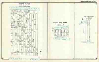
Sold on eBay Nov 24, 2021
1915 Hyde Map of Ocean Beach and Ocean Bay Park, Fire Island
The U.S. Coast Guard Life Saving Station located in the community is illustrated as well. No other detail is included. Title: Ocean Beach. / Ocean Bay Park. / The Breakers. Services include deacidification cleaning flattening and backing.
Sold on eBay Dec 08, 2021
Bacon's London 1880's map #10 Clapham Junction station, town meadows
Find many great new & used options and get the best deals for Bacon's London 1880's map #10 Clapham Junction station, town meadows at the best online prices at eBay! Free shipping for many products!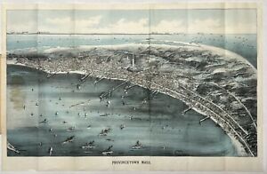
Sold on eBay March 6th, 2024
Rare Original 1910 Provincetown Bird's Eye View Map Pocket Massachusetts Mass MA
Selling a rare original 1910 Provincetown Bird’s Eye View pocket map.The map was published by Walker Lith. & Publishing Co., Boston Mass.Shows good detail of Provincetown street plan including: Provincetown Harbor, wharves, views of the monument, Clapps Pond, Race Point Light, Race Run and Race Point Life Saving Station. In the background it shows: Plymouth, Gurnet Light, Standish Monument, Duxbury Wireless Station, Blue Hills, Boston, Boston Light, Minot Light and the Boston Light Ship. Condition: - Very good overall condition with folds as issued. - Heavy cover with bank note paper map. - Glue appears on the left where it is attached to the cover. - see photos (may possibly be less evident when detached) - Cover can be detached or folded back for framing Measurements: (approx.) Map - Outside Paper 17.75” x 11.5” - Map Image 10.0” x 17.0” (unfolded) Cover 3.25” x 5.5” (folded)The map will be shipped flat and not folded.Please ask questions before purchasing ———————————— As noted on the Norman Leventhal Map and Education Center at the Boston Public in a northwesterly direction toward Cape Cod Bay and the distant Boston shoreline, this bird's eye view portrays Provincetown at a time when the town was transitioning from a community dependent on fishing to one whose economy and culture were increasingly tied to the annual influx of summer residents and a growing artists and writers community. The central focus of this view is most striking architectural feature, the Pilgrim Monument. This 252-foot tower was completed just as the view was published in 1910. Celebrating this locale's historic origins, the monument was built to commemorate the Mayflowers five-week stay at the tip of Cape Cod before the Pilgrims decided to shift their base to Plymouth Bay. The view also provides evidence of the community’s changing economy. Numerous wharves, a mixture of steam and sailing ships in the harbor, and three cold storage plants for processing fish; Consolidated Weir, Provincetown Cold Storage, and Fisherman's Cold Storage reflect the town’s reliance on maritime industries during the 19th century. On the other hand, the identification in the legend of several hotels (Pilgrim, New Central, Atlantic, Gifford, and Mt. Pleasant Houses) and the Star Theater foreshadow the town's developing tourist industry during the 20th century.”
Sold on eBay July 21st, 2024
c1908 TEXAS Map ORIGINAL MK & T Lines Texas Irrigated Land Company OIL FIELDS
RARE ORIGINAL LARGE c1908 ANTIQUE MAP OF TEXASRARE AND UNRECORDED MAPDATE-circa 1908PUBLISHED BY-THE TEXAS IRRIGATED LAND COMPANYORIGINAL LARGE c1908 ANTIQUE MAP OF TEXAS. RARE AND VERY DETAILED MAP OF TEXAS SHOWING THE VARIOUS AGRICULTURAL PRODUCT AREAS INCLUDING COTTON , OIL FIELDS, LIVESTOCK, GRAIN, WHEAT, FRUIT AND MANY OTHERS. TEXAS IS SHOWN IN DIVIDED INTO 5 REGIONS, COAST COUNTRY, EAST TEXAS FRUIT AND TIMBER BELT, SOUTHWEST TEXAS ARTESIAN BELT, BLACK LAND COUNTIES, PANHANDLE AND THE RED RIVER VALLEY. ROUTES OF THE MISSOURI-KANSAS & TEXAS RAILROAD ARE SHOWN IN HEAVY BLACK LINE WITH WHITE DOTS INDICATING TOWNSHIP STATION STOPS. ALSO SHOWN ARE ELEVATIONS, RAINFALL AMOUNTS, COUNTIES, TOWNSHIPS AND WATERWAYS. MAP FOLDS INTO A SMALL PAPER WRAP WITH TITLE ON FRONT WRAP COVER. COVER FRONT IS DETACHED FROM BACK WRAP.MAP IS EXTREMELY RARE AND 22.5 X 21.5 INCHES ENTIRE SHEETFAIR CONDITION, DISCOLORATION, HEAVY CREASING, SMALL EDGE TEARS, FRONT PAPER WRAP IS SEPARATED FROM REAR COVER.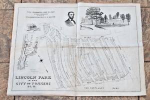
Sold on eBay March 23rd, 2024
Antique 28 X 20" Broadside / Map Lincoln Park Yonkers New York 1893 , NY& N RR
Celebrating more then 25 years as a leading seller of historical items on ebay .If you haven't saved me as a favorite seller yet please consider it ! As with ALL of our listings this is the vintage, real McCoy. This is NOT a copy, NOT a modern day replica. Guaranteed authentic Bought a Large Collection of Early maps , Documents and Broadsides all dealing with the Bronx NYC I will be listing lots over next two weeks !! This uncommon cadastral map offers an early overview of a portion of the Lincoln Park neighborhood in Yonkers, New York. The image, oriented with southwest at the top, numbers nearly 450 lots and their respective acreage between Sedgwick Ave., McLean Ave., Central Park Ave., and Van Cortlandt Park (in the NYC city limits).A profile of the namesake, Abraham Lincoln, can be seen in the upper center, adjacent to an illustrated view of an expansive corner lot. Also present is an inset map showing the location of the development in respect to the rest of New York City and an image of Lincoln Station on the N.Y. & Northern Railroad.The map was designed by Civil Engineer Josiah Ackerman Briggs and lithographed in New York by Robert A. WelckeShips folded on pre existing fold lines Stunning , Clean , Suitable for framing Please view all the photos to make an intelligent decision on condition.Over 25 Years on Ebay , 100% Feedback Thank you for visiting my store and viewing this item , stop by again I list fresh items 365 days a year !! , Mark me as a favorite PLEASE READ ALL THE BORING DETAILSCustomer Service Policy:Please note in bidding or buying this listing you are entering into a binding contract. In bidding or buying you are agreeing to all policies stated below . * Shipping is clearly stated / shown in the listing , by bidding or buying you are agreeing .* The auction or fixed price listing contains only what is described. Do not assume something comes with a used item if it is not stated in the auction / listing verbiage.* You can count on us to be factual as to the best of our knowledge and have clear accurate photographs. * Photographs often disclose condition far better than verbiage as many people have different ideas on what terms may mean.* If an identifying mark, inclusion or defect is visible in the images it is considered "disclosed" to the buyer.I strive to earn 5 Stars on all my transactions , If you feel I haven't please contact me before leaving feedback so that I can personally address your concerns and earn your 5 Star rating !Thank you very much for visiting my auctions I honestly appreciate it . Please add me as a Favorite seller , I list items 52 weeks a year . I list the Antique & Unique , Unusual things & items of distinction .
Sold on eBay September 22nd, 2024
1868 Atlas of New York and Vicinity Map by Frederick Beers NYC Brooklyn Old Book
1868 Atlas of New York and Vicinity Map by Frederick Beers NYC Brooklyn Old Book Fresh from a Multi Generational wealthy estate dating back to the 1840’s. This is from the Varian Estate. Isaac L. Varian was the Mayor of New York City from 1839-41. You are buying a Great Piece of History! You will receive a 1868 Atlas of New York & Vicinity w/ Old Maps. Table of Contents: Plan of New York, Brooklyn Morrisania & West Farms Tremont & Surroundings Fordham, West Farms, Westchester, Villages of Wakefield, Olinville, Williams’ Bridge & Bronxdale, Unionport, Westchester, Schuylerville, Woodlawn Cemetery, Yonkers, Hastings, Dobb’s Ferry, Irvington, Tarrytown, Greenburg & Villages of Ashford & Hart’s Corners, East Chester, Lakeville Waverly Washingtonville Mount Vernon, Pelham and City Island, New Rochelle, Village of Pelhamville, White Plains & Scarsdale, Mamaroneck & Village Orienta, Mamaroneck & Rye Neck, Harrison & Rye and Villages of Rye & Milton, Village of Portchester, Mt. Pleasant and Villages of Pleasantville & Station, North Casetle, Kensico & Armonk, Ossining & Village of Sparta, Borough of Sing Sing, New Castle, Chappaqua, Mt. Kisco, Bedford, Beddford Station, Whitlockville & Katonah, Bedford, Poundridge, Lewisboro & Golden’s Bridge, South Salem, Cortlandt, Peekskill & Villages of Verplanck & Crugers, Yorktown & Shrub Oak & Jefferson Valley, Village of Somers, North Salem, Croton Falls, Purdy’s Station, Salem Centre, Phillipstown & Putnam Valley & Village of Carmel, Cold Spring, Nelsonville, South East Center, Milltown and Towner’s Station, Brester’s Station & Patterson, Kent… Etc. Please see the photos for the exact item you will receive. This Atlas Book is larger in size and has binding separation, some maps have rips and tears. Normal wear for ephemera/paper more than 157+ years old! Please ask any questions prior to bidding. You are buying the item as shown, as is, no returns. Great Historic piece! Please see the photos for the exact item you will receive. All items including Sports Cards, Vintage, Antiques & Collectibles are sold as shown with no returns. Please ask any questions prior to bidding. I will not accept any offer lower than the starting bid. Thank you for taking the time to look at my unique estate fresh treasures! Please check out my other items. Shipping in USA is $25 THANKS FOR LOOKING
Sold on eBay Jan 28, 2019
1908 FT GREENE BROOKLYN NY BISHOP LOUGHLIN HS ATLANTIC AV LIRR STATION ATLAS MAP
This is an original G.W. BROMLEY Atlas Map for the Fort Greene section of Brooklyn, New York, 1908. This was also Walter O'Malley's location to build the first indoor baseball stadium before being turned down my Robert Moses and taking the Dodgers to Los Angeles.
Sold on eBay November 16th, 2024
1928 Folding Map of Tientsin City CHINA - China Marines - 4th Marine Regiment
1928 folding color map and index to the City of Tientsin CHINA. Booklet measures 4.5" x 6.75" and in excellent condition. Folding color map measures 18" x 25" and very detailed. Booklet - index contains 16 pages including Chinese City (inside), Outside City, Japanese Concession, French Concession, British Concession, 1st Special Area, 2nd Special Area, Italian Concession, 3rd Special Area, Belgian Concession. (only a couple pages are photographed). Text is in English and Chinese. Came from a collection of China Marine items. Insured USPS delivery in the Continental US is $ 11.00The term China Marines, originally referred to the United States Marines of the 4th Marine Regiment, who were stationed in Shanghai, China from 1927 to 1941 to protect American citizens and their property in the Shanghai International Settlement, during the Northern Expedition and the Second Sino-Japanese War. Those Marines stationed at the embassy in Beijing and the consulate in Tianjin referred to themselves as North China Marines.[1]Due to the cheap labor available, China Marines lived a relatively comfortable lifestyle, with each squad able to hire Chinese men to do their cleaning and run their errands. This, plus the inexpensive goods available on the local market, made an assignment to the China Marines highly coveted.Most of the China Marines were withdrawn in November 1941, but the North China Marines in Beijing and Tianjin were scheduled to be withdrawn on December 10. (All weapons and ammunition except rifles and pistols had been crated and shipped by rail to the embarkation port.) However, Imperial Japan attacked the United States on December 7, and the Marine Embassy guards, plus a fourteen-man Naval medical detachment, a total of 203 men, were captured and held as slave labor until the war's end in August 1945. A 204th man, a retired officer who had been living in Beijing and recalled to duty, was immediately released. He continued living in Beijing until he was included in the roundup of civilians and sent to the Weixian Internment Camp in March 1943. He was returned to the U.S. on the exchange ship Teia Maru in September 1943. The last commander of the China Marines was Colonel William W. Ashurst.[2]With the rapid expansion of the Marine Corps during World War II and the capture of the rest of the 4th Marine Regiment at Corregidor, the surviving China Marines were few in number and highly regarded.After Japan's surrender, the 1st and 6th Marine Divisions, also known as China Marines, were sent to occupy northern China from 1945 to 1948.On January 31, 1996, Marines from the 2nd Battalion 5th Marines, as part of the 31st Marine Expeditionary Unit (31st MEU), Special Operations Capable (SOC), made their first visit to Shanghai, China, since World War II. The 31st MEU-SOC visited China again on November 22, 2006, during a port visit to Zhanjiang.[3] [full citation needed]American Legion China Post OneAmerican marines holding up a Japanese patrol trying to enter the Shanghai International Settlement, 1930sAmerican Legion China Post One, formed in 1919, one year after World War I and chartered by the American Legion on April 20, 1920, was originally named the General Frederick Townsend Ward Post No. 1, China.[4] It is the only post nominally headquartered in a communist country, and has been operating in exile since 1948 — presently in Henderson, Nevada.[5]In popular cultureAuthor W. E. B. Griffin often writes of China Marines in his book series The Corps. Book 1 of the series in particular highlights the pre-World War II lives of China Marines. In his Presidential Agent series, he several times makes reference to American Legion China Post No. 1 in Exile as a post comprised in the main of retired military special operators who can be hired for assorted purposes.The foreign concessions in Tianjin (formerly romanized as Tientsin) were concession territories ceded by the Qing dynasty to a number of European countries, the United States and Japan within the city of Tianjin. There were altogether nine foreign concessions in old Tianjin on the eve of World War II. These concessions also contributed to the rapid development of Tianjin from the early to mid-20th century. The first foreign concessions in Tianjin were granted in 1860. By 1943, all the foreign concessions, except the Japanese concession, had ceased to exist de facto.General contextPrior to the 19th century, the Chinese were concerned that European trade and missionary activity would upset the order of the empire. Strictly controlled and subject to import tariffs, European traders were limited to operating in Canton and Macao. Following a series of military defeats against Britain and France, Qing China were slowly forced to permit privileges for foreign nationals and even cessions of Chinese sovereignty over certain ports and mineral rights.Troops of the Eight-Nation Alliance, Tianjin, 1900Tianjin's position at the intersection of the Grand Canal and the Hai River connecting Beijing to the Bohai Bay made it one of the premier ports of northern China. Foreign trade was approved there for the British and French by the 1860 Peking Convention. Its importance increased even further when it was connected to the Tangshan coal fields by the Kaiping Tramway, the railroad that eventually connected all of northern China and Manchuria. Between 1895 and 1900, the two original powers were joined by Japan, Germany, Russia, Austria Hungary Italy and Belgium – countries without concessions elsewhere in China – in establishing self-contained concessions each with their own prisons, schools, barracks and hospitals. The European settlements covered 5 square miles (13 km2) in all, the riverfront being governed by foreign powers.[1] After decades, the Japanese, French, and British concessions (which were situated on the right bank of the Peiho River)[1] became the most prosperous ones.With the 1911 Revolution, the new Republic of China managed a restructuring of Chinese domestic and foreign relations, allowing it to recognize European states as equals. In turn, the concessions in Tianjin were dismantled in the early to mid-20th century with successful recognition of the European states of the Republic of China, which gave European property owners equality before Chinese officials. However, World War II disrupted this nascent development: the Japanese seized the concessions of powers allied against it during its occupation of the country. Starting with Britain in 1943, all foreign powers relinquished their concessions in China, including in Tianjin [citation needed]American concession article: American concession of TianjinPostcard from the American concession c. 1900Troops of the 15th Infantry on parade, 1931The United States never requested or received a concession in Tianjin, but a de facto concession was administered from 1869 to 1880, principally under the aegis of the British mission. In 1902, the informal American territory became part of the British concession. The United States maintained a permanent garrison at Tianjin, which was provided from January 1912 to 1938 by the 15th Infantry, US Army and then by the US Marine Corps until December 8, 1941, the day that the United States entered the Second World War and all territories of the United States and the British Empire in Asia and the Pacific faced the threat of attack by the Empire of Japan.[citation needed]Lloyd Horne recalled of his time there in the 1930s, "I was detailed with the 15th Infantry to rescue missionaries that were being trapped there. It was like they were prisoners — they couldn't even come out of their billets without getting fired on or having rocks thrown at them [2]American Marines in Tianjin, (c.1930s, early 1940s)Austro Hungarian concession article: Austro Hungarian concession of TianjinTroops of the Austro Hungarian naval corps in Tianjin c. 1903–04Austria Hungary participated in the Eight-Nation Alliance that suppressed the Boxer Rebellion (1899–1901). Austria-Hungary together with Italy sent the smallest force of the Eight-Nation Alliance. Four cruisers and 296 Hungarian enlisted soldiers were dispatched [3]On December 27, 1902, Austria-Hungary gained a concession zone in Tianjin as part of the reward for its contribution to the Alliance. The Austro Hungarian concession zone was 150 acres (0.61 km2) in area, situated next to the Pei-Ho river and outlined by the Imperial channel and the Tianjin-Beijing railway track. Its population was around 30,000 people. Order was maintained by 40 Austro Hungarian marines and 80 Chinese militia (Shimbo).The self-contained concession had its own thermae, theatre, pawnshop, school, barracks, prison, cemetery and hospital. It also contained the Austro Hungarian consulate and its citizens were under Austro Hungarian, not Chinese rule. Despite its relatively short life-span, the Austrians left their mark on the area, as can be seen in the Austrian architecture in the city.The administration was done by a town council composed of local high-class noblemen and headed by the Austro Hungarian consul and the military commander, the two of them had a majority vote. The focus of the juridical system was on smaller crimes and it was based on Austro Hungarian law. If a Chinese person committed a crime on Chinese soil he could be tried in their own courts [4]Yuan s mansion in the Austro Hungarian concession, built in 1908–1918Austria Hungary was, due to World War I, unable to maintain control of its concession. The concession zone was swiftly occupied by China at the Chinese declaration of war on the Central powers and on 14 August 1917 the lease was terminated, along with that of the larger German concession in the same city.[5] Austria finally abandoned all claim to it on September 10, 1919 (Treaty of Saint Germain en Laye) Hungary made a similar recognition on June 4, 1920 (Treaty of Trianon). The former Austro Hungarian concession renamed the "Second Special District", was placed under the permanent administration of the Chinese government [note 1]Belgian concession article: Belgian concession of TianjinThe Belgian Concession was established in 1902 after Belgian envoy Maurice Joostens claimed the parcel in the negotiations following the defeat of the Boxer rebels. Located on the eastern bank of the Hai River (Hai He), the Belgian government and business community did not invest in development of the concession. The concession was nominal and of little value and an agreement to return the concession to China was signed in August 1929 and approved by the Belgian parliament in 1931.[6]Main street in the Belgian concession, 1907Much more important were contracts involving railways, electric power systems and tramways built and partly operated by Belgian private companies. In 1904, China and Belgium signed a contract with the Compagnie de tramways et d'éclairage de Tientsin, giving the company an official monopoly for 50 years over trams and electric lighting in the city. In 1906, with the opening of the first route of the tramway system, Tianjin became the first Chinese city to have a modern public transportation system (Shanghai had to wait until 1908 to get electric tramways). The supply of electricity and lighting and the trolley business were profitable ventures. By 1914, the network covered the Chinese city as well as the Austrian, French, Italian, Japanese and Russian concessions [citation needed]The Compagnie de tramways et d'éclairage de Tientsin was taken over by the Japanese army in 1943 and the members of the Belgian staff, often with their families, were sent to internment camps. Following the end of World War II, the Chinese authorities took over the network. The Brussels-based company tried to get compensation, but the Chinese Communist Revolution in 1949 left them without any indemnity. Two more lines were built under Chinese administration, but the network was finally closed around 1972.[citation needed]British concession Road, British concession, 1920sBritish Indian troops on parade in Tianjin in the 1920sMain article: British concession of TianjinThe British concession, which contained the trade and financial centres, was situated on the right bank of the river Haihe below the native city, occupying some 200 acres (0.81 km2). It was held on a lease in perpetuity granted by the Chinese government to the British Crown, which sublet plots to private owners in the same way as was done at Hankou.[1]The local management was entrusted to a municipal council organized on lines similar to those in Shanghai.[1] The seat of government was the stately Gordon Hall, situated on the financial street called Victoria Road (now Jiefang Lu).The British concession was blockaded by the Japanese during the Tientsin incident in June 1939, causing a major diplomatic crisis.The Japanese occupied the British concession upon their declaration of war against Britain on 7 December 1941 until the end of the war.[citation needed]The British concession in Tianjin was formally returned to China with the Sino-British Treaty for the Relinquishment of Extra Territorial Rights in China, ratified on 20 May 1943, although the Chinese could not take possession until the end of the war ended the Japanese occupation [citation needed]French concession section does not cite any sources. Please help improve this section by adding citations to reliable sources. Unsourced material may be challenged and removed. (January 2024) (Learn how and when to remove this Day in 1911Rue de FranceThe French concession was established in 1860. After more than 100 years, almost every prominent building in the original concession is still extant, including the French Consulate, the Municipal Council, the French Club, the Catholic Cathedral, the French Garden and many others. Many of the bank buildings along the financial street (currently Jiefang Lu, formerly the Rue de France) are still in existence today.French armoured car White TBC in Tianjin during the 1928 troublesThe villas around the Garden Road are beautiful and diverse. Many French celebrities lived in Tianjin. Among them, Paul Claudel (consul 1906 - 1909), and the natural scientist Father Emile Licent who conducted research in Tianjin from 1914 to 1939. He founded the Musee Hoang-Ho Pai-Ho (Museum of Yellow River and Peiho River) and left it 20,000 specimens of animals, plants and fossils, as well as 15,000 books. In 1998, the Tianjin government rebuilt the Tianjin Nature Museum.The dome of the French Cathedral was damaged during the Cultural Revolution: some young Red Guards climbed to the top of the dome to destroy the cross, though later the Tianjin government not only repaired the cross but also renovated the entire church.German concession article: German concession of TianjinBy the late 1870s, the German Empire was on a course of extensive economic involvement in several Chinese provinces, among them the Tianjin area. The German enclave south of the Hai River was situated between the British and one of the Japanese concessions. In July 1877 xenophobic groups threatened the life and property of German merchants in Tianjin. Local unrest intensified, mainly due to poor harvests and resulting famine, and Tianjin business interests requested armed protection. The German admiralty then dispatched the corvette SMS Luise to China. This initial show of support eventually evolved into a permanent presence in Chinese waters by initially modest German naval forces. It have total area of 2 km2Street in the German concession on the eve of World War IThe German Boxer War Memorial, 1905After Germany acquired the Kiautschou Bay region in 1898 with a 99-year lease, a further concession was negotiated for the Tianjin enclave and economic growth escalated with infrastructure improvements. Major trading houses and diverse enterprises established themselves, including a branch of the Deutsch Asiatische Bank. The Boxer Rebellion of 1900 initially laid siege to the foreign concessions in Tianjin, but the city was secured and used as a staging area for the eventual march on Peking by the eight-nation international relief forces.China swiftly occupied the German concession after it declared war on the Central Powers in August 1917. In 1919, the former concession, renamed the "First Special District", was placed under the permanent administration of the Chinese government. The United States 15th Infantry was billeted in the former German barracks from 1917 until 1938, departing only after the Imperial Japanese Army entered Tianjin.Italian concession article: Italian concession of TianjinBritish and Italian units marching in TianjinOn September 7, 1901, Italy was granted a concession in Tianjin from the Chinese government. On June 7, 1902, the Italians took control of the concession, which was to be administered by an Italian consul. It became the headquarters[7] of the Italian Legione Redenta (an "Italian legio" made of irredentist troops in the defeated Austro Hungarian empire), that fought in 1919 against Lenin's Soviet troops in Siberia and Manchuria [8]The Italian World War I monument and the Piazza Regina ElenaThe Italians occupied temporarily during WW1 the Austrian concession, but withdrew from it in 1919 (while annexing some minor sections of this former concession) When Tianjin became in danger of being stormed by warring factions during the civil war of 1927–1928, Italian troops temporarily occupied the Second Special District of the city in order to protect the city's power station and main railway station. They withdrew after a short while.[9]In 1935, the Italian Concession had a population of about 6,261, including about 536 foreigners. The Regia Marina (Italian Royal Navy) stationed some vessels in Tianjin. During World War II, the concession had a garrison of approximately 600 Italian troops.On September 10, 1943, when Italy signed an armistice with the Allies, the concession was occupied by the Imperial Japanese Army. Later in 1943, the Italian Social Republic (RSI) ceded the concession to Wang Jingwei's Japanese sponsored Chinese puppet state, the Reorganized National Government of China. The Italians were never to regain control over the concession and the Republic of Italy's surrender of all its rights over it by the peace treaty of 1947, was therefore a mere formality Japanese concession concession of Concession of the Empire of JapanHistory • Established1898 by Succeeded by Qing DynastyRepublic of China (1912-1949) Asahi Road, Japanese concession (c 1928 1940[10])The Japanese concession was initially established in 1898 in the aftermath of the First Sino-Japanese War and additional areas were added in 1900–1902 after the Boxer Rebellion. In 1937, the Imperial Japanese Army (IJA) occupied the entire city of Tianjin excluding the foreign concessions. These were occupied in 1941 and in 1943. The Japanese concession ceased to exist with the capitulation of Japan in 1945.In 1924, the last emperor of the Qing dynasty, Puyi, was forced to leave the Forbidden City in Beijing and lived in Tianjin until 1931 when he was forcibly taken by the Japanese army to Dalian. The imperial concubine Wenxiu divorced Puyi in Tianjin, which was the first time in Chinese dynastic history that an imperial concubine divorced an emperor.Russian concession article: Russian concession of TianjinThe Russian consulate in Tianjin in 1912A treaty granting a concession to the Russian Empire in Tianjin was signed 31 December 1900. Even before the official treaty was signed, the general in charge of the Russian forces in the city since the Boxer Rebellion had already laid claim to the future concession by right of conquest and Russian troops had already begun placing boundary markers. The concession, on the left bank of the Peiho River, was larger than any of the other foreign concessions, which according to the agreement was due to "Russian trade at Tientsin being on the increase".[11] In reality, Russian economic involvement in Tientsin was insignificant and became even more so after the Russian defeat in the Russo-Japanese War. For this reason, the concession remained largely underdeveloped The 398 hectares (3.98 km2) concession was divided into two non-contiguous districts (east and west). In 1920, the Chinese Beiyang government retook the land and concession from Russia during its widescale civil war, and in 1924 the Soviet Union renounced its claim on the concession.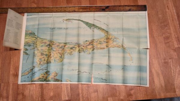
Sold on eBay October 30th, 2024
New Rare Bird's Eye View Of Cape Cod Map 1905 By John H. Murphy
Extremely rare Bird's Eye View Of Cape Cod Map 1905 By John H. Murphy. An internet search shows that only a few copies of this have been sold. Boston rare maps sold a copy. The library of Congress owns a copy. This is a color bird's eye view of Cape cod and part of Martha's vineyard Steamship lines are indicated as well as points of interests are labeled. The map is in good condition but does have tears. Many of the folds have small tears. Please see all the photos for the tears. I have taken pictures of all the individual tears. This map is suitable for framing and there is very little surface lost at the tears. It would look great in a frame that would preserve it Published by John F. Murphy South station Boston Massachusetts news agent eastern district. N.Y.N.H. & H.R.R. and Fall River line steamers and Rowes wharf
Sold on eBay December 7th, 2023
1867 Town of Ridgefield Connecticut antique map ~ rare ~ 17" x 13.8" hand color
eBay 1867 Town of Ridgefield, Fairfield County Connecticut antique map with insets of Tutticus & Ridgefield Station, along with corresponding directories Description:A beautiful and colorful map from the F.W. Beers Atlas of New York & Vicinity, published in 1867. This map has great presence and nice original hand coloring - would look great framed Condition: Overall, very good+ condition. The map has typical wear commensurate with age - minor toning & minor staining (exactly as pictured ) Dimensions of Map (including margins):~13.8" Wide~17" TallIncluded: Every map order comes with one Crystal Clear archival bag - Acid freeShipping: first class & fully insured. I am always willing to combine shipping for multiple lots won.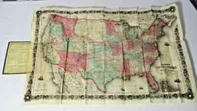
Sold on eBay Mar 22, 2021